|
Highway 401 | |||
|---|---|---|---|
| Macdonald–Cartier Freeway | |||
 Highway 401 within Southern Ontario | |||
| Route information | |||
| Maintained by the Ministry of Transportation of Ontario | |||
| Length | 828.0 km[1] (514.5 mi) | ||
| History |
| ||
| Major junctions | |||
| West end | Ojibway Parkway in Windsor | ||
| |||
| East end | |||
| Location | |||
| Country | Canada | ||
| Province | Ontario | ||
| Major cities | Windsor, London, Kitchener, Cambridge, Mississauga, Toronto, Oshawa, Kingston and Cornwall | ||
| Highway system | |||
| |||
|


King’s Highway 401, commonly referred to as Highway 401 and also known by its official name as the Macdonald–Cartier Freeway or colloquially referred to as the four-oh-one,[3]
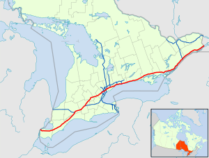
is a controlled-access 400-series highway in the Canadian province of Ontario. It stretches 828 kilometres (514 mi) from Windsor in the west to the Ontario–Quebec border in the east. The part of Highway 401 that passes through Toronto is North America’s busiest highway,[4][5] and one of the widest.[6][7]
Together with Quebec Autoroute 20, it forms the road transportation backbone of the Quebec City–Windsor Corridor, along which over half of Canada’s population resides. It is also a Core Route in the National Highway System of Canada.
The route is maintained by the Ministry of Transportation of Ontario (MTO) and patrolled by the Ontario Provincial Police. The speed limit is 100 km/h (62 mph) throughout its length, with the only exceptions the posted 80 km/h (50 mph) limit westbound in Windsor and in most construction zones, along with a 110 km/h (68 mph) speed limit between Windsor and Tilbury.[8]
By the end of 1952, three individual highways were numbered «Highway 401»: the partially completed Toronto Bypass between Weston Road and Highway 11 (Yonge Street); Highway 2A between West Hill and Newcastle; and the Scenic Highway between Gananoque and Brockville, now known as the Thousand Islands Parkway. These three sections of highway were 11.8, 54.7 and 41.2 km, (7.3, 34.0 and 25.6 mi), respectively. In 1964, the route became fully navigable from Windsor to the Ontario–Quebec border. In 1965 it was given a second designation, the Macdonald–Cartier Freeway, in honour of two Fathers of Confederation. At the end of 1968, the Gananoque–Brockville section was bypassed and the final intersection grade-separated near Kingston, making Highway 401 a freeway for its entire 817.9-km length. Since 2007, a portion of the highway between Trenton and Toronto has been designated the Highway of Heroes, as the route is travelled by funeral convoys for fallen Canadian Forces personnel from CFB Trenton to the coroner’s office.
In 2011, construction began on a westward extension called the «Rt. Hon. Herb Gray Parkway». This new route follows but does not replace, the former Highway 3 between the former end of the freeway and the E. C. Row Expressway, at which point it turns and parallels that route towards the site of the future Gordie Howe International Bridge. An 8-kilometre (5 mi) section of the parkway, east of the E. C. Row interchange, opened on June 28, 2015, with the remaining section completed and opened on November 21. In the summer of 2019, the widening of the highway between Highway/Regional Road 8 in Kitchener to Highway/Regional Road 24 in Cambridge to twelve lanes was completed. There are plans underway to widen the remaining four-lane sections between Windsor and London to six lanes and to widen the route between Cambridge and Milton as well as through Oshawa. The expansive twelve-plus-lane collector–express system through Toronto and Pickering, and partially across Mississauga, was extended west to Milton in December 2022.
Route description[edit]

Highway 401 extends across Southwestern, Central and Eastern Ontario. In anticipation of the future expansion of the highway, the transportation ministry purchased a 91.4-metre-wide (300 ft) right-of-way along the entire length. Generally, the highway occupies only a portion of this allotment.[9]
It is one of the world’s busiest highways;[6] a 2016 analysis stated the annual average daily traffic (AADT) count between Weston Road and Highway 400 in Toronto was nearly 420,000,[1]
while a second study estimates that over 500,000 vehicles travel that section on some days.[5] This makes it North America’s busiest roadway, surpassing the Santa Monica Freeway in Los Angeles and I-75 in Atlanta.[7][10] The just-in-time auto parts delivery systems of the highly integrated automotive industry of Michigan and Ontario have contributed to the highway’s status as the world’s busiest truck route,[11] carrying 60 percent of vehicular trade between Canada and the US.[7]
Highway 401 also features North America’s busiest multi-structure bridge at Hogg’s Hollow in Toronto.[11]
The four bridges, two for each direction with the collector and express lanes, carried an average of 373,700 vehicles daily in 2006.[1]
The highway is one of the major backbones of a network in the Great Lakes region, connecting the populous Quebec City–Windsor corridor with Michigan, New York and central Ontario’s cottage country.[12]
It is the principal connection between Toronto and Montreal, becoming Autoroute 20 at the Ontario–Quebec border.[13]
Southwestern Ontario[edit]
Highway 401 does not yet extend the last few kilometres to Detroit;[14] an extension to Brighton Beach (at the Canada–US border in Windsor) was completed in November 2015, after which the Gordie Howe International Bridge will extend Highway 401 across the Canada–United States border to a connection through Delray to Interstate 75 in Michigan by the end of 2024.[15]
At present, Highway 401 begins as a six-lane freeway at the west end of the E. C. Row Expressway. At the Dougall Parkway, the highway turns east and exits Windsor.[16] From here, Highway 401 mostly parallels the former route of Highway 98 from Windsor to Tilbury.[17]

Southwestern Ontario is flat, primarily agricultural land, that takes advantage of the fertile clay soil deposited throughout the region.[18][19]
The main river through the region is the Thames River, which drains the second largest watershed in southern Ontario and largely influences the land use surrounding the highway.[20]
It parallels the route to the north between Tilbury and Woodstock.[16]
Near Tilbury, Highway 401 loses its tall wall median barrier and narrows to four lanes, following lot lines laid between concession roads in a plan designed to limit damage to the sensitive agricultural lands through which the highway runs.[21]
Here the highway’s flat and straight route is notorious for leading to driver inattention.[22]
The section from Windsor to London (especially west of Tilbury) has become known for deadly car accidents and pile-ups, earning it the nickname Carnage Alley.[23]
As the highway approaches London, Highway 402 merges in,[16] resulting in a six-lane cross-section.[24][25]
Within London, it intersects the city’s two municipal expressways, Highbury Avenue and the Veterans Memorial Parkway.[26]
The section between London and Woodstock generally parallels the former Highway 2 but lies on the south side of the Thames River.[16] This area is not as flat but the highway is generally straight. This part of Highway 401 often experiences heavy snowsqualls in early winter, sometimes extending as far east as Toronto. To the south of Woodstock, Highway 401 curves northeast and the western terminus of Highway 403 merges into it.[26] From here the highway heads towards Kitchener and Cambridge, substantially north of the route of the former Highway 2 as Highway 403 assumes the role of paralleling the former Highway 2 all the way to Mississauga.
Heading towards Kitchener the highway intersects with Highway 8 and returns to its eastward orientation.[16][27] Between Highway/Regional Road 8 and Highway/Regional Road 24 in Cambridge, the highway was widened in 2020 to twelve lanes to accommodate the growing traffic using that segment.[28][29][30]
Beyond Highway/Regional Road 24, the highway returns to a six-lane cross section and meanders towards Milton, passing through hills and rock cuts along the way.[31]

Highway 401 at Weston Road has a volume of over 500,000 vehicles per day during the summer months.
Greater Toronto Area[edit]
As Highway 401 approaches the Greater Toronto Area (GTA), it descends through the ecologically protected Niagara Escarpment to the west of Milton.[32][33]
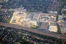
Upon entering the town, it enters the first urbanized section of the GTA, passing through two rural areas between there and Oshawa.[16][34] Part of this rural gap is the western side of Toronto’s Greenbelt, a zone around Toronto protected from development.[32] After this 10 km (6.2 mi) gap, the highway interchanges with the Highway 407 Express Toll Route. Within the GTA, the highway passes several major shopping malls including Yorkdale Shopping Centre, Scarborough Town Centre and Pickering Town Centre.[35][36][37]

Different colours are used on the signs on Highway 401’s collector-express system to avoid confusion. The express lanes use green signs and the collector lanes use blue.
Highway 401 widens into a collector-express system[38] (the first of three distinct sets) as it approaches James Snow Parkway in Milton, a concept inspired by the Dan Ryan Expressway in Chicago.[9] The system divides each direction of travel into collector and express lanes,[39]
giving the highway a wide span and four carriageways. To avoid confusion between carriageways, blue signs are used for the collector lanes and green signs for the express lanes. Unlike the collector lanes, which provide access to every interchange, the express lanes only provide direct access to a select few interchanges. Access between the two is provided by transfers, which are strategically placed to prevent disruptions caused by closely spaced interchanges.[40]
The overall purpose of the collector-express system is to maximize traffic flow for both local and long-distance traffic. In addition, Highway 401 was equipped with a traffic camera system called COMPASS in early 1991.[41]
Using closed-circuit television cameras, vehicle detection loops and LED changeable-message signs, COMPASS enables the MTO Traffic Operations Centre to obtain a real-time assessment of traffic conditions and alert drivers of collisions, congestion and construction.[42]
The system stretches from the Highway 403 / 410 interchange in Mississauga to Harwood Avenue in Ajax.[43]

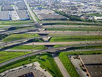
«The Basketweave», just east of the Highway 400 interchange, is a free-flowing crossover between the collector and express lanes.
Three sets of collector-express systems exist in the GTA. The first set is 4.6 km (2.9 mi) long from James Snow Parkway to Highway 407. The second set is 16.7 km (10.4 mi) long and runs from Winston Churchill Boulevard to Highway 427, initially terminating just west of Highway 410 in the early 1990s, but since the 2010s has extended westward in stages to include the interchanges with Hurontario Street, Mavis Road, and Mississauga Road, with the final extension to Winston Churchill being completed in 2022.[44]
This system was originally designed to accommodate and organize various traffic movements from the Highway 403 / 410 and Highway 427 interchanges along Highway 401, replacing an earlier plan that would have run Highway 403 directly to Eglinton Avenue and the never-built Richview Expressway.[45]
East of the interchange with Renforth Drive, the collector lanes diverge to become the on-ramps to Highway 427 northbound and southbound. The second 43.7 km (27.2 mi) system starts from Highway 409 and passes through the centre of Toronto, ending at Brock Road in Pickering to the east.[46]
The 5 km (3.1 mi) gap between the two systems is a traffic bottleneck as the freeway narrows to only 8 lanes beneath Highway 427. However, the interchange with Highway 427 cannot accommodate future widening of Highway 401.[10]

Highway 401 widens to 18 lanes south of Toronto Pearson International Airport.[7] Progressing eastward, eight lanes are carried beneath the large spaghetti junction at Highway 427. The highway curves northeast and follows a power transmission corridor to Highway 409, which merges with the mainline and forms the collector lanes. It returns to its eastward route through Toronto, now carrying 12–16 lanes of traffic on four carriageways.[38]
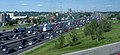
Highway 401 is often congested in this section, with an average of 442,900 vehicles passing between Weston Road and Highway 400 per day as of 2008.[1][7] In spite of this congestion, it is the primary commuting route in Toronto; over 50 percent of vehicles bound for downtown Toronto use the highway.[47]
East of Highway 400 is The Basketweave, as each direction has a criss-crossing transfer between the express and collectors carriageways.[38] Near Yorkdale Shopping Centre, twelve lanes pass beneath a complicated interchange with Allen Road, built to serve the cancelled Spadina Expressway. Further east, the highway crosses Hogg’s Hollow, over the West Don River and Yonge Street in the centre of Toronto, the busiest multi-span bridge crossing in North America, surpassing the Brooklyn Bridge. It then crosses the East Don River and climbs toward an interchange with the Don Valley Parkway and Highway 404, which provides access to downtown Toronto and the suburbs to the north, respectively.[citation needed]
Highway 401 just west of Leslie Street
Progressing eastward in Scarborough, the Highway 401 continues through mostly residential areas and Scarborough City Centre including the shopping mall, eventually reaching the city’s eastern edge where former Highway 2A merges into it at a vast interchange with Kingston Road and Port Union Road, and crossing the Rouge Valley into Pickering.[38]
West of Pickering, Highway 401 again meets former Highway 2, which thereafter parallels it to the Ontario–Quebec border.[16] As the highway approaches Brock Road in Pickering, the collector and express lanes converge, narrowing the 14-lane cross-section to 10, divided only at the centre.[48]
It remains this width as it passes into Ajax,[38]
before narrowing to six lanes at Salem Road.[49]
Planned expansions east of Salem to improve flow leading into the Highway 412 and Lakeridge Road interchanges will see the highway widened to ten lanes as far as Brock Street in Whitby, where the existing interchange will be reconfigured.[50]
East of Ajax, the highway passes through the second 3.5 km (2.1 mi) rural gap, and enters Whitby. The stretch of Highway 401 through Whitby and Oshawa features several structures completed during the initial construction of the highway in the 1940s.[10] Several of these structures are to be demolished, either due to their age, or to prepare for the planned widening of Highway 401 through this area.[51]
A former Canadian National Railway overpass, which was fenced off but commonly used by pedestrians during Highway of Heroes repatriations, was demolished on the night of June 11, 2011. A second structure in Bowmanville was demolished during two overnight closures on July 9 and 16.[52]
At Harmony Road, the suburban surroundings quickly transition to agricultural land. The highway curves around the south side of Bowmanville and travels towards Highway 35 and Highway 115.[34]
-
Traffic cameras are mounted at every exit within Toronto and form one part of the COMPASS system.
-
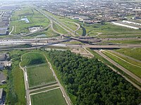
The collector-express system just east of the Highway 400 interchange, with the «Basketweave» transfers between them in the background.
-
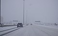
Winter conditions on Highway 401 in Toronto due to a snowsquall.
-

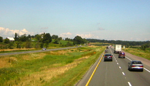
Newly-opened in 2022, collector-express system in Mississauga viewed from Second Line West bridge
Eastern Ontario[edit]
Through much of eastern Ontario, Highway 401 is a rural freeway with a grass median.
From east of Highway 35 and Highway 115 to Cobourg, Highway 401 passes through a mix of agricultural land and forests, maintaining a straight course.[53]
Highway 401 passes through the north end of the towns of Port Hope and Cobourg with two interchanges each. Just east of Cobourg, the highway narrows to four lanes and the terrain becomes undulating, with the highway routed around hills and through valleys along the shores of Lake Ontario.[54]
At Trenton, the highway crosses the Trent Canal and returns to an agricultural setting. It then crosses the Moira River as it goes through Belleville before heading eastward to Kingston.[13] The Kingston portion of the highway, originally named the Kingston-Bypass, was one of the first sections of the highway to be completed;[2] it is now mostly three lanes each way.[55]

East of Kingston, the highway continues through a predominantly agricultural area alongside the St. Lawrence River to Gananoque, where it splits with the Thousand Islands Parkway,[56] one of the original sections of the highway designated in 1952.[57] The highway runs parallel to the parkway several kilometres inland from the river. The Canadian Shield, an ancient geological formation, appears through this heavily forested section of the highway. Highway 401 rejoins the Thousand Islands Parkway immediately southwest of Brockville, now heading northeast.[58]
The remainder of the highway runs parallel to the former Highway 2 along the shore of the St. Lawrence River within the St. Lawrence Valley. Northeast of Brockville is the interchange with Highway 416, which heads north to Ottawa.[59] At the Ontario–Quebec border, Highway 401 becomes Autoroute 20 and continues to Montreal.[60]
Traffic volume[edit]
The MTO publishes yearly traffic volume data for provincial highways, expressed as an average daily vehicle count over the span of a year (AADT).[1]
The table below compares the AADT at several locations along Highway 401 using data from 1969, 1988, 2008 and 2016.
| Location | Section | Traffic volume (AADT) | |||
|---|---|---|---|---|---|
| 1969[61] | 1988[1] | 2008[1] | 2016[1] | ||
| Windsor | Dougall Parkway – Essex County Road 46 | 9,550 | 13,200 | 16,700 | 17,500 |
| London | Highbury Avenue – Veterans Memorial Parkway | 17,450 | 33,800 | 64,500 | 64,200 |
| Woodstock | Oxford County Road 59 – Highway 403 | 16,700 | 35,100 | 67,100 | 67,500 |
| Cambridge | Highway 8 – Highway 24 | 19,900 | 50,400 | 125,600 | 137,300 |
| Mississauga | Mississauga Road – Hurontario Street | 28,450 | 97,100 | 177,300 | 216,500 |
| Toronto | Weston Road – Highway 400 | 106,850 | 319,600 | 442,900 | 416,500 |
| Oshawa | Stevenson Road – Simcoe Street | 29,000 | 79,000 | 120,700 | 134,200 |
| Belleville | Highway 62 – Highway 37 | 13,750 | 22,500 | 43,500 | 45,300 |
| Kingston | Frontenac County Road 38 – Sydenham Road | 12,000 | 20,700 | 45,400 | 55,000 |
| Brockville | Highway 29 – North Augusta Road | 10,050 | 15,300 | 29,100 | 33,600 |
| Cornwall | Highway 138 – McConnell Avenue | 10,300 | 12,900 | 18,400 | 21,400 |
| Location | Lane count | Distance |
|---|---|---|
| E C Row Expressway to Essex County Road 42 | 6 lanes | 55.7 km (34.6 mi) |
| Essex County Road 42 to Highway 402 | 4 lanes | 127.5 km (79.2 mi) |
| Highway 402 to Highway 8 | 6 lanes | 94.6 km (58.8 mi) |
| Highway 8 to Highway 24 (Hespeler Road) | 12 lanes | 3.0 km (1.9 mi) |
| Highway 24 (Hespeler Road) to Halton Regional Road 25 | 6 lanes | 37.1 km (35.0 mi) |
| Halton Regional Road 25 to James Snow Parkway | 10 lanes | 4.3 km (35.0 mi) |
| James Snow Parkway to Highway 407 | 12-lane collector-express system | 5.3 km (3.5 mi) |
| Highway 407 to Winston Churchill Blvd. | 10 lanes | 3.3 km (3.5 mi) |
| Winston Churchill Blvd. to Highway 403 / 410 | 12-lane collector-express system | 10.5 km (3.5 mi) |
| Highway 403 / 410 to Highway 427 | 18-lane collector-express system | 5.8 km (3.6 mi) |
| Highway 427 to Highway 27 | 8 lanes | 0.8 km (0.50 mi) |
| Highway 27 to Highway 409 | 10 lanes | 3.9 km (2.4 mi) |
| Highway 409 to Brock Road | 12–16-lane collector-express system | 43.3 km (26.9 mi) |
| Brock Road to Salem Road | 10 lanes | 6.0 km (3.7 mi) |
| Salem Road to 4.5 km east of Baltimore Street | 6 lanes | 74.8 km (46.5 mi) |
| 4.5 km east of Baltimore Street to Frontenac County Road 38 | 4 lanes | 131.7 km (81.8 mi) |
| Frontenac County Road 38 to Highway 15 | 6 lanes | 12.2 km (7.6 mi) |
| Highway 15 to ON–QC border | 4 lanes | 205.0 km (127.4 mi) |
History[edit]
Predecessors[edit]

Highway 401 colour-coded by the year each section opened to traffic
Highway 401’s history predates its designation by over two decades. As automobile use in southern Ontario grew in the early 20th century, road design and construction advanced significantly. Following frequent erosion of Lake Shore Road, then macadamized,[62]
a concrete road known as the Toronto–Hamilton Highway was proposed in January 1914. Construction began on November 8 of that year, following the onset of World War I.[63][64]
The highway was designed to run along the lake shore, instead of Dundas Street to the north, because the numerous hills encountered along Dundas would have increased costs without improving accessibility. Middle Road, a dirt lane named because of its position between the two, was not considered since Lake Shore and Dundas were both overcrowded and in need of serious repairs.[65]
The road was formally opened on November 24, 1917,[62][63] 5.5 m (18 ft) wide and nearly 64 km (40 mi) long. It was the first concrete road in Ontario, as well as one of the longest stretches of concrete road between two cities in the world.[66]
Over the next decade, vehicle usage increased substantially, and by 1920, Lakeshore Road was again congested, particularly during weekends.[67]
In response, the Department of Highways examined improving another road between Toronto and Hamilton. The road was to be more than twice the width of Lakeshore Road at 12 m (39 ft) and would carry two lanes of traffic in either direction.[68]
Construction on what was then known as the Queen Street Extension west of Toronto began in early 1931.[69]
Before the highway could be completed, Thomas McQuesten was appointed the new minister of the Department of Highways, with Robert Melville Smith as deputy minister, following the 1934 provincial elections.[10]
Smith, inspired by the German autobahns—new «dual-lane divided highways»—modified the design for Ontario roads,[70]
and McQuesten ordered the Middle Road be converted into this new form of highway.[71][72][73]
A 40 m (130 ft) right-of-way was purchased along the Middle Road and construction began to convert the existing sections to a divided highway. Work also began on Canada’s first interchange at Highway 10.[68]

Beginning in 1935, McQuesten applied the concept of a dual-highway to several projects along Highway 2, including along Kingston Road in Scarborough Township.[10][74]
When widening in Scarborough reached the Highland Creek ravine in 1936, the Department of Highways began construction on a new bridge over the large valley, bypassing the former alignment around West Hill.[75]
From here the highway was constructed on a new alignment to Oshawa, avoiding construction on the congested Highway 2.[9] As grading and bridge construction neared completion on the new highway between West Hill and Oshawa in September 1939, World War II broke out and gradually tax revenues were re-allocated from highway construction to the war effort.[10]
At the same time, between September 6 and 8, 1939, the Ontario Good Roads Association Conference was held at Bigwin Inn, near Huntsville,[76]
drawing highway engineers from across North America to discuss the new concept of «Dual Highways.» On the first day of the convention, McQuesten announced his vision of the freeway: an uninterrupted drive through the scenic regions of Ontario, discouraging local business and local traffic from accessing the highway except at infrequent controlled-access points.[77]
It was announced in the days thereafter this concept would be applied to a new «trans-provincial expressway», running from Windsor to the Ontario–Quebec border.[78]

The former Highway 2A near Highland Creek, aside from a resurfaced pavement, has not been altered since it opened in 1947.
Highway engineers evaluated factors such as grading, curve radius, and the narrow median used along the Middle Road—which was inaugurated on August 23, 1940 as the Queen Elizabeth Way (QEW)[79]—and began to plan the course of a new dual highway mostly parallel to Highway 2, with precedence given to areas most hampered by congestion. Unlike the QEW, this highway would not be built along an existing road, but rather on a new right-of-way, avoiding the need to provide access to properties.[10][77]
Along with immense improvements to machinery and construction techniques over its six-year course, the war provided planners an opportunity to conduct a survey of 375,000 drivers, asking them about their preferred route to travel to their destination. Using this information, a course was plotted from Windsor to Quebec, bypassing all towns along the way.[9][80]
Highway 2S (S for Scenic) was the first completed section of new roadway. Built to connect with the Thousand Islands Bridge at Ivy Lea and opened as a gravel road in late 1941 or early 1942,[81]
the road followed the shore of the Saint Lawrence River and connected with the western end of the twinned Highway 2 near Brockville.[16]
In addition, the highway between Highland Creek and Oshawa was opened as a gravel-surfaced road in May 1942.[82]
Following the war, construction resumed on roadways throughout Ontario. The expressway between Highland Creek and Oshawa was completed in December 1947,[9] while other sections languished. The Toronto–Barrie Highway was the primary focus of the Department of Highways at the time, and the onset of the Korean War in 1950 stalled construction again. Despite the delays, highway minister George Doucett officially announced the plans for construction of the new trans-provincial expressway that year, with the Toronto to Oshawa expressway serving as a model for the design.[10] Work on the most important link, the Toronto Bypass, began in 1951,[10] but it would not open with that name.

The Highway 400 interchange in 1953. Today, the former cloverleaf has been replaced with a multilevel interchange.
Assumption[edit]
In July 1952 (possibly July 1, the same day Highway 400 was numbered),[a][57]
the Highland Creek to Oshawa expressway and Highway 2S were designated Controlled-Access Highway No 401,[9] a move scorned by one critic because of the lack of thought given to the numbered name.[83]
Construction was completed for several sections of the Toronto Bypass: between Highway 400 and Dufferin Street in August, west to Weston Road in September, east to Bathurst Street in October and finally to Yonge Street in December.[2]
Extensions east and west began in 1953; the eastern extension to Bayview Avenue opened in April 1955,[2] but the western extension was delayed by the damage caused by Hurricane Hazel on October 15, 1954, which nearly destroyed the new bridge over the Humber River. The reconstruction would take until July 8, 1955,[84]
and the highway was opened between Weston and Highway 27 in September 1955.[2]
Within years after opening, the four-lane Toronto Bypass was congested, prompting the Department of Highways to widen this section to 12 lanes beginning in 1963.
The entire bypass, including the widening of Highway 27 into an expressway south of Highway 401,[9][85]
was completed in August 1956.[2][9]
Upon its opening, the bypass was described by one reporter as «a motorist’s dream» providing «some of the most soothing scenery in the Metropolitan area». The reporter continued, with regard to the eastern section through Scarborough, that it «winds smoothly through pastures across streams and rivers, and beside green thickets. It seems a long way from the big city.»[9]
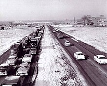
By 1959 however, the bypass was a lineup of cars, as 85,000 drivers crowded the roadway, designed to handle a maximum of 48,000 vehicles, on a daily basis.[9]
Motorists found the new road to be a convenient way of travelling across Toronto; this convenience helped influence the suburban shift in the city and continues to be a driving force of urban sprawl today.[57]
Meanwhile, beyond Toronto, the highway was being built in a patchwork fashion, focusing on congested areas first.[10] Construction west from Highway 27 began in late 1954,[86]
as did the Kingston Bypass in Eastern Ontario.[87]
Work began to connect the latter with the Scenic Highway in 1955.[86]
After the 1954 New York State Thruway opened from Buffalo to New York City,[88] Michigan officials encouraged Ontario to bypass Highway 3 as the most direct path from Detroit to Buffalo.[89]
By 1956, construction had begun on a segment between Highway 4 in London and Highway 2 in Woodstock, as well as on the section between Windsor and Tilbury.[90]

A plaque near Brockville commemorates the official completion of the highway.
In 1958, a section bypassing Morrisburg was opened to accommodate traffic displaced from a portion of Highway 2 through The Lost Villages of the Saint Lawrence Seaway.[91]
By the end of 1960, the Toronto section of the highway was extended both eastwards and westwards: first east from Newcastle to Port Hope on June 30; then later west from Highway 25 in Milton to Highway 8 south of Kitchener on November 17.[2]
By mid-1961, the section between Brighton and Marysville had opened.[92] The gap to the east, from Highway 28 in Port Hope to Highway 30 in Brighton was opened on July 20 of that year.[93]
The gap between Woodstock and Kitchener was completed on November 9, 1961, while the gap between Tilbury and London was completed two lanes at a time; the westbound lanes on October 22, 1963, the eastbound on July 20, 1965.[2] The gap between Marysville and Kingston was opened by 1962.[92]
The final sections, from west of Cornwall to Lancaster, were opened between 1962 and 1964;[92][94]
two lanes opened to Lancaster on September 11, 1962, but the other two were not completed until July 31, 1964. The last segment, to the Ontario–Quebec border, was opened on November 10, 1964.[2]
Finally, on October 11, 1968, the Thousand Islands Bypass opened.[9] This final piece was commemorated with a plaque to signify the completion of Highway 401.[10]
Expansion[edit]
The widening of Highway 401 from four to twelve lanes in Toronto took nine years and was accomplished with at least four lanes open at all times. Shown here is the Highway 401 / Don Valley Parkway / Highway 404 interchange under construction in 1965.
In Toronto, engineers and surveyors were examining the four-lane bypass, while planners set about designing a way to handle the commuter highway. In 1963, transportation minister Charles MacNaughton announced the widening of Highway 401 in Toronto from four to a minimum of 12 lanes between Islington Avenue and Markham Road. The design was taken from the Dan Ryan Expressway in Chicago, which was widened into a similar configuration around the same time.[9] Construction began immediately. While the plan initially called for construction to end in 1967, it continued for nearly a decade. At least four lanes were always open during the large reconstruction project, which included complex new interchanges at Highway 27, Highway 400, the planned Spadina Expressway and the Don Valley Parkway. The system was completed in 1972, along with the Highway 27 (renamed Highway 427) bypass between the QEW and Pearson Airport. Most of the interchanges in Toronto were reconstructed as partial cloverleafs and a continuous lighting system was installed.[10]
On January 11, 1965, at the dinner celebration of Sir John A. Macdonald’s 150th birthday, the Premier of Ontario John Robarts designated Highway 401 the Macdonald–Cartier Freeway to honour Macdonald and George-Étienne Cartier, two of Canada’s Fathers of Confederation.[95][96]
Unlike other names later applied to the highway, the Macdonald–Cartier Freeway designation covers the entire length of Highway 401. Signs designating the freeway and shields with the letters ‘M-C’ were installed, but these had been removed by 1997.[97]
In 2003, 38 years after Robarts’ naming of the highway, a Member of Provincial Parliament attempted to get the Macdonald-Cartier Freeway highway name enshrined into law; the bill only passed first reading and was not enacted.[98]
In the 1970s, Highway 401 was widened to six lanes in Durham. Between 1977 and 1982, Highway 401 was widened from four to six lanes between Hurontario Street (Highway 10) to Highway 25, with the Jersey median barrier making its debut in Ontario in that segment.[10]

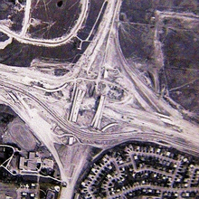
The Highway 401-403-410 interchange looking east in 1987. At the time the Highway 401 collector and express lanes merged prior to crossing Tomken Road. At the time Highway 410 was only a Super two highway which connected to Highway 401 east of the interchange.
The expanded interchange looking north in 2013, showing the flyover ramps between Highway 401 and Highway 410 with the Highway 401 express lanes underneath them.
The 1980s saw more sections widened. Most significant was the new collector-express system between Highway 403 / 410 and Highway 427, including a new set of flyover ramps from the express lanes to Highway 403 which opened in 1984, while a basketweave transfer between the eastbound collector and express lanes near Pearson Airport was completed in mid-1985.[99]
After the Kennedy Road overpass was replaced, cast-in-place concrete flyover ramps were constructed from 1988 to late 1990 to link up Highway 401 and Highway 410, notably the 11-span flyover ramp from Highway 401 eastbound to Highway 410 northbound which remains the longest in the Greater Toronto Area, while the Highway 410 southbound to Highway 401 eastbound flyover replaced a loop ramp. In the fall of 1991, alongside the widening of Highway 410 into a full freeway, construction began on the connecting ramps between Highway 403 and Highway 410, which pass under the existing bridge structures carrying Highway 401 (which would soon be designated as the collector lanes), while new overpasses were constructed for the Highway 401 express lanes which were extended from east of Tomken Road to just east of Kennedy Road.[100][101]

Highway 401 at Meadowvale Road in 1989, before being widened to a 14-lane collector-express system
Plans were made to extend the eastern system from Neilson Road to Brock Road in Pickering in the late 1980s,[102]
but took over a decade to reach fruition by 1997.[103][104][105]
This was followed shortly thereafter by the widening of the highway through Ajax and a new interchange at Pickering Beach Road (renamed Salem Road) and Stevenson Road.[106]
The 1990s also saw the first step in widening the highway from Toronto to London, by replacing the grass median with the addition of a third traffic lane per direction separated by a tall-wall concrete median barrier. The segment from London to Woodstock received this upgrade first, with the expansion ending near the terminus of Highway 403’s newly constructed western segment.[107]
A project in the mid-1990s brought the highway up to a minimum of six lanes between Highway 8 in Kitchener and Highway 35 / 115 in Newcastle.[108]
Other projects prepared sections for eventual widening.[109]
In its 2007 plan for southern Ontario, the MTO announced long-term plans to create high-occupancy vehicle (HOV) lanes from Mississauga Road west to Milton;[110]
by 2011 these plans had been expanded in scope to as far west as Hespeler Road in Cambridge.[111]

Hwy. 401 widening work in Mississauga looking east from the Mississauga Road overpass in 2020
In the late 1990s, several prerequisite projects were undertaken for the future widening of Highway 401 throughout Mississauga, including a new underpass structure to accommodate Derry Road which was widened from two to six lanes (1996–97), the addition of an interchange with the Mavis Road extension in 1999 whose overpass was designed to be lengthened with two outer spans,[112] and replacing the Mississauga Road overpass which began on February 15, 2002 [113] (in a cost-sharing agreement between the province and Peel Region) and completed in 2003,[10] although that section of the freeway would retain its six-lane cross section for the next decade. More recent work included the replacement of the McLaughlin Road overpass in 2008.[114][115] Starting in 2009, Highway 401’s collector-express lanes in Mississauga have been extended westward beyond its initial terminus at Highway 410.[112][114] The widening of this 7 km segment to the Credit River necessitated the replacement of several existing overpasses, including those of Hurontario Street (2013) and Second Line West (2016), with the Second Line West crossing rebuilt as a pedestrian/cyclist bridge since most vehicular traffic was already rerouted to the Mavis Road extension.[116][117] Tying into this extension of Highway 401’s collector-express system, the missing ramps from Highway 401 eastbound to Highway 403 westbound and the opposite movement were completed in 2018[112] which also provided direct access to Cawthra Road, making the Highway 401-403-410 junction a full four-way interchange.[118]
The first phase of this expansion to west of Hurontario Street, a distance of 2.8 km (1.7 mi), opened in 2013,[119]
while the second phase to the Credit River was completed in 2020.[120]
A successful construction consortium was announced in 2019 for expanding the route from the Credit River to Regional Road 25 in Milton to a minimum of 10 lanes, including an HOV lane. This project included extending the existing 12-lane collector–express system from the Credit River to just east of Winston Churchill Boulevard, while another 12-lane collector–express system was built from just west of the Highway 407 interchange to just east of the James Snow Parkway.[121]
Sections of the new expansion were opened overnight throughout the second half of 2022. On August 13 and 14, 2022, the westbound express lanes opened between Highway 407 and James Snow Parkway. The remainder of the westbound lanes, between the Credit River and Winston Churchill Boulevard, were opened several months later on November 13 and 14. The eastbound express lanes between James Snow Parkway and Winston Churchill Boulevard were opened a week later on November 18 and 19, and from Winston Churchill Boulevard to the Credit River on November 29 and 30. The HOV lanes in both directions were opened on December 9, 2022, to complete the project.[122][123]
Advantage I-75[edit]
Between June 1990 and 1998, Highway 401 and Interstate 75 were used for a pilot project named Advantage I-75 to test the reliability and versatility of an automated tracking system for transport trucks. Termed «MACS» (Mainline Automated Clearance System), it allows a truck to travel from Florida to Ontario without a second inspection.[124]
MACS was initially tested at two truck inspection stations in Kentucky, with transponders installed in 220 trucks. Exact time, date, location, weight and axle data were logged as a truck approached an equipped station.[125]
Following initial tests, MACS was deployed at every inspection station along I-75 from Miami to Detroit, and along Highway 401 from Windsor to Belleville in 1994.[124] The project demonstrated the effectiveness of electronic systems in enforcing freight restrictions without delaying vehicles, while alleviating security fears such systems could be compromised. The concept has since been applied to many parts of Canada, including Highway 407’s electronic tolling system.[126]
«Carnage Alley»[edit]
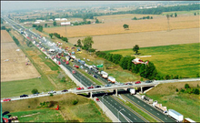
The 87-vehicle pile up on September 3, 1999
The section of Highway 401 between Windsor and London has often been referred to as Carnage Alley, in reference to the numerous crashes that have occurred throughout its history. The term became more commonplace following several deadly pileups during the 1990s.[10] The narrow and open grass median was an ineffective obstacle in preventing cross-median collisions. The soft shoulders consisted of gravel, with sharp slopes which were blamed for facilitating vehicle rollovers.[127]
The nature of that section of highway, described as a mainly straight road with a featureless agricultural landscape, was said to make drivers feel less involved and lose focus on the road. In winter, the area between Woodstock and Chatham is also subject to sudden snow squalls from lake-effect snow.[128]
Several collisions have resulted from motorists deviating from their lane and losing control of their vehicles.[127][129]
Various other names, including The Killer Highway circulated for a time,[130]
but Carnage Alley became predominant following an 87-vehicle pile-up on September 3, 1999 (the start of Labour Day weekend), the worst in Canadian history, that resulted in eight deaths and 45 injured individuals.[131]

Only a few days prior, then-Transportation Minister David Turnbull had deemed the highway «pleasant» to drive.[132]
On the morning of September 3, the local weather station reported clear conditions due to a malfunction,[131] while a thick layer of fog rolled onto the highway. Dozens of vehicles, including several semi-trailers, quickly crashed into each other shortly after 8 a.m., one following another in the dense fog, with collisions in both directions at that segment of Highway 401, although no vehicles crossed the highway’s median.[133][134]
Immediately following the crash, the MTO installed paved shoulders with rumble strips[135]
and funded additional police to patrol the highway, a move criticized as being insufficient.[136]
Beginning in 2004, 46 km (29 mi) of the highway was widened from four asphalt lanes to six concrete lanes, paved shoulders were added, and a concrete Ontario Tall Wall median was installed,[137]
which was the solution the Canadian Automobile Association promoted in 1999.[127] Interchanges were improved and signage was upgraded as part of a five-phase project to improve Highway 401 from Highway 3 in Windsor to Essex County Road 42 (formerly Highway 2) on the western edge of Tilbury.[24]
From 2008 to 2010, with joint funding from the provincial and federal governments, the section of Highway 401 from Dougall Parkway (former Highway 3B) to Provincial Road (former Highway 98) was widened to six lanes, necessitating the replacement of the Walker Road and Provincial Road underpasses for the freeway’s elevated section. As part of that project, the Dougall Parkway split with Highway 401 was reconfigured, replacing a one-lane 1950s-era underpass tunnel with a modern high-speed flyover ramp. The old interchange had reduced eastbound Highway 401 traffic to one lane as it merged with Dougall Parkway, whereas the new interchange allows three lanes per direction of Highway 401 to pass through.[138]
Highway of Heroes[edit]

Canadians line overpasses along the Highway of Heroes to pay their respects to fallen soldiers.
On August 24, 2007, the MTO announced the stretch of Highway 401 between Glen Miller Road in Trenton and the intersection of the Don Valley Parkway and Highway 404 in Toronto would bear the additional name Highway of Heroes (French: Autoroute des héros), in honour of Canadian soldiers who have died,[139]
though Highway 401 in its entirety remains designated as the Macdonald–Cartier Freeway.[140]
This length of the highway is often travelled by a convoy of vehicles carrying a fallen soldier’s body, with his or her family, from CFB Trenton to the coroner’s office at the Centre for Forensic Sciences in Toronto. Since 2002, when the first fallen Canadian soldiers were repatriated from Afghanistan, crowds have lined the overpasses to pay their respects as convoys pass.[141]

The origin of the name can be traced to an article in the Toronto Sun on June 23, 2007, by columnist Joe Warmington, in which he interviewed Northumberland photographer Pete Fisher. Cobourg resident Ron Flindall was responsible for organizing the first bridge salutes following the loss of four soldiers on April 18, 2002.[142][143]
Warmington described the gathering of crowds on overpasses to welcome fallen soldiers as a «highway of heroes phenomena».[144]
This led a Cramahe Township volunteer firefighter to contact Fisher on July 10 about starting a petition, leading Fisher to publish an article which was posted to the Northumberland Today website.[145]
The online article eventually caught the attention of London resident Jay Forbes. Forbes began a petition, which received over 20,000 signatures[139] before being brought to the Minister of Transportation on August 22.[146]
Following the announcement on August 24, the provincial government and MTO set out to design new signs. The signs were erected and unveiled on September 7,[140] and include a smaller reassurance marker (shield), as well as a larger billboard version.[147]
On September 27, 2013, the Highway of Heroes designation was extended west to Keele Street in Toronto, to coincide with the move of the coroner’s office to the new Forensic Services and Coroner’s Complex at the Humber River Hospital.
Highway improvements and safety concerns[edit]
London and Kitchener[edit]

Between 2006 and 2008, Highway 401 was widened from four to six lanes between Highway 402 and Wellington Road in London. This included reconfiguring the Wellington Road interchange from a cloverleaf to a Parclo A4 while replacing the original 1956 overpass with a longer and wider structure.[24]
In November 2010, the widening of Highway 401 from four to six lanes between Woodstock and Kitchener was completed after many years of planning and construction.[148]
The project included the installation of a tall-wall median barrier, straightening curves and adding additional interchanges on the freeway, allowing it to be easily vacated in an emergency event.[149]
Greater Toronto Area[edit]
Beginning in 1998, several projects were initiated on Highway 401 within Toronto. The freeway’s pavement through the city was resurfaced. The most significant construction work was widening the route from six to eight lanes though the Highway 427 interchange in 2005, which necessitated the replacement of the Highway 27 underpass, although the rest of the junction’s flyovers could accommodate the expansion.[6] Some projects have been completed during overnight construction projects, including the widening and rehabilitation of the Hogg’s Hollow bridge,[150]
the replacement of the original gantries throughout the collector-express system,[151] and rehabilitating the flyover ramps of the Highway 401 / 400 interchange.[152][153]

On August 10, 2008, following a series of explosions at a propane facility in Toronto, Highway 401 was closed between Highway 400 and Highway 404 as a precautionary measure, the largest closure of the highway in its history.[154]
The highway remained closed until 8 p.m., though several exits near the blast remained closed thereafter.[155][156]
In Oshawa, exit 416 (Park Road) was replaced by a new interchange at exit 415 (Stevenson Road). The contract, which began September 7, 2005, included the interchange and the resurfacing of 23.4 km (14.5 mi) of the highway between Oshawa and Highway 35 / Highway 115.[157]
The westbound ramps were opened in mid-September 2007[158]
and the eastbound ramps in mid-2009. The resurfacing was completed mid-2010.[157]
In 2013, as a prerequisite to construction of the West Durham Link which was eventually numbered as Highway 412, the section of Highway 401 near the Lake Ridge Road overpass was shifted northward on a new alignment away from the parallel railway line to allow sufficient right-of-way for the interchange to the new route.[159][160] The interchange to Highway 412 opened on June 20, 2016.[161]
Rt. Hon. Herb Gray Parkway[edit]
In 2004, a joint announcement by the federal government of the United States and Government of Canada confirmed a new border crossing would be constructed between Detroit and Windsor. The Detroit River International Crossing (DRIC) was formed as a bi-national committee to manage the project.[162]
The MTO took advantage of this opportunity to extend Highway 401 to the Canada–US border and began an environmental impact assessment on the entire project in late 2005.[162]
The City of Windsor also hired New York traffic consultant Sam Schwartz to design a parkway to the border. Schwartz’s proposal would eventually inspire the DRIC’s own design, but his route was not chosen, with the DRIC opting instead to take a northern route.[163]
On February 8, 2008, the MTO announced it had begun purchasing property south of the E. C. Row Expressway, upsetting many area residents who had purchased properties in the years prior.[164][165]
On March 3, 2008, the Michigan Department of Transportation and the MTO (in partnership with Transport Canada, the Federal Highway Administration of the United States and the Detroit River International Crossing group) completed a joint assessment on the soils along the Detroit River and determined they could indeed support the weight of a new bridge; the stability of the underlying soil and clay and the impact of the nearby Windsor Salt Mine had caused concern for all parties involved in the project.[166]
Despite protest from area residents,[167]
as well as a dismissed lawsuit from Ambassador Bridge owner Matty Moroun,[168][169]
it was announced on May 1, 2008, that a preferred route had been selected and the new route would be named the Windsor–Essex Parkway.[170]
The new parkway is below-grade and has six through-lanes. It follows (but does not replace) Talbot Road and Huron Church Road from a new interchange at the former end of Highway 401 to the E. C. Row Expressway, where it runs concurrently westward for 2 km (1.2 mi). From there, it turns northwest and follows a new alignment to the border.[171]
Internally, the new parkway was numbered Highway 7901.[1]
Initial construction of a noise barrier from North Talbot Road to Howard Avenue began in March 2010; full construction began on August 19, 2011.[172]
On November 28, 2012, the Ministry of Transportation announced a Federal Order in Council was passed to change the name of the parkway to the «Rt. Hon. Herb Gray Parkway», in honour of the Right Honourable Herb Gray, a Member of Parliament from Windsor.[173]
In early 2015, it was announced the parkway would open to traffic between Highway 3 and Labelle Street (near the E. C. Row Expressway) in the spring;[174]
an 8-kilometre (5 mi) section was opened to traffic on June 28, extending Highway 401 as far west as the E. C. Row Expressway. It was the first new segment of the highway to be opened since the Thousand Islands Parkway bypass in 1968.[175]
The stretch to Ojibway Parkway was opened on November 21,[176]
completing the parkway as far as the planned bridge approach and border plaza.[177]
Construction on projects related to the Gordie Howe International Bridge began in 2015 with an initial completion date in 2019–20.[178]
The «Bridging North America» consortium was selected to build the bridge in July 2018, with construction beginning immediately.[179]
The Gordie Howe International Bridge is expected to be completed by the end of 2024.[15]
Future[edit]
Southwestern Ontario[edit]

Highway 401 in the Greenbelt, at the interchange with Guelph Line. The stretch of Highway 401 between Highway 8 and Highway 407 ETR is slated to be widened from six to ten lanes, including two HOV lanes.
In Southwestern Ontario, several improvements are under way to provide six lanes on Highway 401 from Windsor to Toronto,[180]
in response to the 1999 Highway 401 crash in Carnage Alley.[137][181]
West of Essex County Road 42 on the west of Tilbury, the highway has been widened to six lanes with a concrete divider in anticipation of the Rt. Hon. Herb Gray Parkway.[170][182]
Within the London area, traffic volumes are expected to increase considerably, leading to poor highway conditions. The province has put in place an extensive plan to widen and reconstruct the London corridor between 2006 and 2021.[183] This included building a new interchange with Wonderland Road which opened in November 2015 to help improve access to Highway 401 westbound from the city’s southwest end and involved replacing the Westminster Drive overpass to allow the highway to be widened.[184] A reconstruction of the outdated cloverleaf interchange at Colonel Talbot Road[185] and widening Highway 401 from four to six lanes between Highway 4 and Highway 402 is also proposed.[186][187][188] The MTO is also planning on widening Highway 401 from six to eight lanes through part of the London corridor.[189][190]
In the Kitchener/Cambridge area, the Y-junction between Highway 401 and Highway 8 Expressway is to be expanded to a full all-directional interchange, with flyover ramps linking eastbound Highway 401 to Highway 8 towards Kitchener and Highway 8 traffic towards Toronto to westbound Highway 401 to bypass the existing connection using King Street, giving Highway 401 direct freeway access to the Conestoga Parkway.[29][191] The widening of Highway 401 from six to twelve lanes from Highway 8 (King Street) to Highway/Regional Road 24 (Hespeler Road) commenced on June 8, 2015 and concluded in summer 2019.[28][29][192] The second phase of expansion scheduled for 2019-21 will see Highway 401 widened from six to ten lanes between Highway/Regional Road 24 and Townline Road.[193][194][28] At the interchange with Highway 24 (Hespeler Road), the span carrying northbound traffic which opened in 1989 was torn down on May 1, 2021, with both directions of Highway 24 traffic temporarily relocated to the overpass originally built in 1960 and designated for southbound drivers since 1989, as a new overpass is being constructed to accommodate Highway 401’s expanded cross-section.[195][196]
Greater Toronto Area[edit]
Expansion in Durham includes widening the highway to 12 lanes, and extending the collector-express system from its end at Brock Road in Pickering to Lake Ridge Road in Whitby.[197]
A Transportation Environmental Study Report was completed on widening highway 401, extending the collector-express system easterly through to the Highway 412 interchange in Whitby, then ten lanes easterly to Liberty Street in the Municipality of Clarington. The assessment was completed in March 2015.[198] From Liberty Street in Clarington to Highway 35/115, Highway 401 was widened from six to eight lanes.
To support this widening, all of the original overpasses dating back in the 1940s and 1950s built through Whitby and Oshawa was replaced with new overpasses as part of modern highway safety standards and to allow for a future highway widening.[199]
Eastern Ontario[edit]
East of Durham, the MTO is planning to widen parts of Highway 401 to six lanes.[180] Two bridges have been widened in advance of an eventual widening to six lanes of the highway including the bridges over the Trent River in Trenton,[200] as well as the Salmon River bridge between Belleville and Napanee.[201]
By 2020, the highway was widened to six lanes for 9 km (5.6 mi) through Kingston between exits 611 and 623.[202] Construction began in 2014 to expand the highway to six lanes approximately five kilometres (3.1 mi) east of exit 474 in Cobourg.[203]
Services[edit]
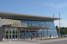
ONroute Cambridge South service station
Highway 401 features 19 ONroute service centres operated under contract from the Ministry of Transportation. They provide a place to park, rest, eat and refuel 24 hours a day.[9] Service centres along Highway 401 were first announced in 1961 following public outcry over the lack of rest stops. The centres were originally leased to and operated by several major gasoline distributors; however, those companies chose not to renew their leases as the terms ended.[citation needed]
In response, the MTO put the operation of the full network of service centres out for tender, resulting in a 50-year lease agreement in 2010 with Host Kilmer Service Centres, a joint venture between hospitality company HMSHost (a subsidiary of Autogrill) and investment company Kilmer van Nostrand.[204]
Seventeen of the centres along Highway 401 have been reconstructed entirely. Two centres rebuilt in the late 1990s, specifically Newcastle and Ingersoll, were not redeveloped at that time. Work on rebuilding 15 of the 17 service centres began in late 2009 or early 2010. The new service centres, opened in phases beginning in July 2010, feature a Canadian Tire gas station, an HMSHost-operated convenience store known as «The Market», as well as fast food brands such as Tim Hortons, A&W, Pizza Pizza, Extreme Pita, KFC, Taco Bell, Big Smoke Burger and Burger King.[205]
| Location | Direction(s) | Nearby exits[206] | Status[205] |
|---|---|---|---|
| Tilbury North | Westbound | 56, 63[207] | Reopened as of October 1, 2010[208] |
| Tilbury South | Eastbound | ||
| West Lorne | Westbound | 137, 149 | Reopened as of October 1, 2010[208] |
| Dutton | Eastbound | ||
| Ingersoll | Westbound | 222, 230 | Will not be redeveloped at this time. Leased by Imperial Oil.[citation needed] |
| Woodstock | Eastbound | Closed for reconstruction on March 31, 2010; reopened July 2011[209] | |
| Cambridge North | Westbound | 286, 295 | Closed for reconstruction on September 7, 2011;[210] Cambridge North reopened June 25, 2013; Cambridge South reopened July 23, 2013.[211] |
| Cambridge South | Eastbound | ||
| Mississauga | Eastbound | 333, 336[212] | Opened in 1991 as the Mississauga Info Centre serving only passenger vehicle traffic; included tourism info terminals and a business centre. Was leased to Shell. Permanently closed as of September 30, 2006 with building demolished in December 2010. Site redeveloped as the OPP Mississauga Detachment.[213] |
| Newcastle | Westbound | 440, 448 | Will not be redeveloped at this time. Leased by Imperial Oil.[citation needed] |
| Port Hope | Eastbound | 448, 456 | Reopened by June 2011[citation needed] |
| Trenton North | Westbound | 509, 522 | Reopened as of October 1, 2010[208] |
| Trenton South | Eastbound | Reopened March 2011[citation needed] | |
| Napanee | Westbound | 582, 593 | Closed for reconstruction March 31, 2010;[214] reopened June 2011[citation needed] |
| Odessa | Eastbound | 599, 611 | Open during 2010–11 reconstruction (while a new structure was built directly west of a now-demolished original facility on same property). New facility opened June 2011[citation needed] |
| Mallorytown North | Westbound | 675 | Reopened February 1, 2011[215] |
| Mallorytown South | Eastbound | 685 | Reopened June 28, 2012.[211] |
| Morrisburg | Eastbound | 750, 758 | Reopened as of October 1, 2010[208] |
| Ingleside | Westbound | 758, 770 | Reopened April 2011[208] |
| Bainsville | Westbound | 825 | Reopened as of October 1, 2010[208] |
| Closed |
Exit list[edit]
The following table lists the major junctions along Highway 401, as noted by the Ministry of Transportation of Ontario.[1]
See also[edit]
- Heavy Rescue: 401—a documentary/reality series on Discovery Channel in Canada and The Weather Channel in the United States highlighting the operations of heavy rescue and recovery towing businesses along the highway and nearby roads.
- Southern Ontario Transportation
Explanatory notes[edit]
- ^ The Department of Highways Fiscal Report for the year ending March 31, 1952, claims «Controlled Access Highways nos. 400 and 401 were signed». However, all other sources claim July.
Citations[edit]
- ^ a b c d e f g h i j Ministry of Transportation of Ontario (2016). «Annual Average Daily Traffic (AADT) counts». Retrieved January 1, 2021.
- ^ a b c d e f g h i Ministry of Transportation and Communications (1972). pp. 8–9.
- ^ «Appendix 2: Common Abbreviations». Ontario/ Rhône-Alpes Student Exchange Program Handbook 2020-2021 for Rhône-Alpes students studying in Ontario (PDF). Ontario Program Office, Ontario/Rhône-Alpes Exchange Program, York University. March 2020. p. 31.
401 The Four-Oh-One: highway between Windsor and the Ontario / Québec border
- ^ Allen, Paddy (July 11, 2011). «Carmageddon: The World’s Busiest Roads». The Guardian. Guardian News & Media Ltd. Archived from the original on July 15, 2014. Retrieved July 11, 2014.
- ^ a b Maier, Hanna (October 9, 2007). «Chapter 2». Long-Life Concrete Pavements in Europe and Canada (Report). Federal Highway Administration. Archived from the original on May 27, 2010. Retrieved May 1, 2010.
The key high-volume highways in Ontario are the 400-series highways in the southern part of the province. The most important of these is the 401, the busiest highway in North America, with average annual daily traffic (AADT) of more than 425,000 vehicles in 2004 and daily traffic sometimes exceeding 500,000 vehicles.
- ^ a b c Canadian NewsWire (August 6, 2002). Ontario Government Investing $401 Million to Upgrade Highway 401 (Report). Ministry of Transportation of Ontario.
Highway 401 is one of the busiest highways in the world and represents a vital link in Ontario’s transportation infrastructure, carrying more than 400,000 vehicles per day through Toronto.
- ^ a b c d e Thün, Geoffrey; Velikov, Kathy. «The Post-Carbon Highway». Alphabet City. Archived from the original on July 5, 2010. Retrieved January 2, 2012.
It is North America’s busiest highway, and one of the busiest in the world. The section of Highway 401 that cuts across the northern part of Toronto has been expanded to eighteen lanes, and typically carries 420,000 vehicles a day, rising to 500,000 at peak times, as compared to 380,000 on the I-405 in Los Angeles or 350,000 on the I-75 in Atlanta (Gray).
- ^ Ontario Newsroom (2022). «Ontario Raising Highway Speed Limits». Retrieved March 29, 2022.
- ^ a b c d e f g h i j k l m Shragge pp. 93–94.
- ^ a b c d e f g h i j k l m n o «Highway 401: The Story». John G. Shragge. 2007. Archived from the original on March 28, 2008. Retrieved February 12, 2010.
- ^ a b «Engineering Feats: 401 is the Busiest Highway in North America». The Midland Free Press. Sun Media. 2008. Archived from the original on July 14, 2011. Retrieved March 5, 2010.
- ^ Ministry of Transportation (2003).
- ^ a b Google (March 5, 2010). «Driving directions from Toronto, ON to Montreal, QC» (Map). Google Maps. Google. Retrieved March 5, 2010.
- ^ Ministry of Transportation (2003), section T18–19.
- ^ a b «$3.8B to Build Gordie Howe Bridge, Complete by End of 2024». CBC News. September 28, 2018. Retrieved September 29, 2018.
- ^ a b c d e f g h i Ontario Back Road Atlas (Map). Cartography by MapArt. Peter Heiler Ltd. 2010. ISBN 978-1-55198-226-7.
- ^ Queen’s Printer for Ontario (1969). Ontario Official Road Map (Map). Government of Ontario.
- ^ «Location and Geography of Sarnia–Lambton». Government of Ontario. Archived from the original on July 1, 2011. Retrieved May 7, 2011.
- ^ Planning Department. «Land Use History». City of Windsor. Archived from the original on May 18, 2012. Retrieved April 2, 2012.
- ^ «Thames River: Fact Sheet». The Canadian Heritage Rivers System. Archived from the original on April 26, 2012. Retrieved August 5, 2010.
- ^ Butorac p. 10.
- ^ Hall, Joseph (October 2, 1999). «Boredom Becomes a Killer on 401 ; Straight and Smooth, ‘Carnage Alley’ Encourages a Lethal Lack of Attention». News. The Toronto Star. p. 1. Archived from the original on November 7, 2012. Retrieved March 24, 2010.
- ^ «Crash Area Long Known as ‘Carnage Alley’«. News. The Toronto Star. June 8, 2000. p. A. 4. Archived from the original on November 7, 2012. Retrieved March 24, 2010.
- ^ a b c Ministry of Transportation of Ontario (March 2007). Canada and Ontario Making Improvements to Highway 401 in Essex County (Report). Canadian News Wire.
- ^ Ministry of Transportation of Ontario (June 26, 2006). «Canada and Ontario Improving Highway 401 in London». Transport Canada. Archived from the original on October 21, 2012. Retrieved March 14, 2010.
- ^ a b London & Area (Map). MapArt. 2008. ISBN 978-1-55368-648-4.
- ^ Ministry of Transportation (2003), section R23–24.
- ^ a b c Record staff (September 3, 2014). «Cambridge Committee Grants Weekend Noise Exemption for Hwy. 401 Work». Waterloo Region Record. Kitchener. Archived from the original on November 12, 2014. Retrieved November 12, 2014.
During the next four years, construction crews will widen Highway 401 from six to 10 lanes and rebuild four overpasses that stretch across the highway.
- ^ a b c Record Staff (June 5, 2015). «Highway 401 Widening Work Starts Monday in Cambridge». The Record. Waterloo Region: Metroland Media. Archived from the original on July 14, 2016. Retrieved November 8, 2017.
- ^ Planning Housing and Community Services, Transportation Planning (March 31, 2009). «Highway 8 and Highway 401 Interchange Improvements». Region of Waterloo. Archived from the original on June 13, 2012. Retrieved January 2, 2012.
- ^ Butorac.
- ^ a b Carter-Whitney, Maureen; Esakin, Thomas C. (2010). Ontario’s Greenbelt in an International Context (PDF) (Report). Canadian Institute for Environmental Law and Policy. p. 7. ISBN 978-0-9812103-4-6. Archived (PDF) from the original on July 24, 2011. Retrieved May 5, 2010.
- ^ McIlwraith p. 222.
- ^ a b Rand McNally 2007, p. 4.
- ^ «Directions». Yorkdale Shopping Centre. Archived from the original on May 14, 2011. Retrieved March 10, 2011.
- ^ «Directions». Scarborough Town Centre. Archived from the original on May 12, 2009. Retrieved March 10, 2011.
- ^ «Directions / Mall Hours». Pickering Town Centre. Archived from the original on March 9, 2011. Retrieved March 10, 2011.
- ^ a b c d e MapArt (2008). Golden Horseshoe (Map). Peter Heiler Ltd. pp. 103, 107–112, 266–267, 459, 466. § E3–K44, R8–S16, E44–F46. ISBN 978-1-55198-877-1.
- ^ Lorenz, Matt; Elefteriadou, Lily (July 2000). «A Probabilistic Approach to Defining Freeway Capacity and Breakdown» (PDF). Fourth International Symposium on Highway Capacity, Proceedings. The Pennsylvania Transportation Institute: 85. Archived (PDF) from the original on December 7, 2010. Retrieved June 10, 2010.
- ^ Yagar, Sam; Hui, Richard (January 26, 2007). «Systemwide Analysis of Freeway Improvements». Transportation Research Record. 1554: 172–183. doi:10.3141/1554-21. ISSN 0361-1981. Archived from the original on January 28, 2013. Retrieved April 23, 2010.
- ^ Ministry of Transportation of Ontario. «About COMPASS: Systems in Operation». Toronto (Highway 401) COMPASS System. Government of Ontario. Archived from the original on February 14, 2010. Retrieved March 1, 2010.
- ^ Ministry of Transportation of Ontario. «Freeway Traffic Management Systems». Government of Ontario. Archived from the original on December 15, 2008. Retrieved March 1, 2010.
- ^ Ministry of Transportation of Ontario. «Interactive Map». Traffic Cameras. Government of Ontario. Archived from the original on June 7, 2011. Retrieved March 1, 2010.
- ^ Google (December 6, 2022). «Highway 401 Between Winston Churchill Blvd. and Highway 427» (Map). Google Maps. Google. Retrieved December 6, 2022.
- ^ Toronto Transportation Plan (Map). City of Toronto. 1959.
- ^ Google (January 31, 2021). «Highway 401 between Highway 409 and Brock Road» (Map). Google Maps. Google. Retrieved January 31, 2021.
- ^ M.M Dillon Limited (July 1983). «Executive Summary». Don Valley Corridor Transportation Study (Report). Metropolitan Toronto Technical Transportation Planning Committee. p. iii.
nearly 52% of the vehicles entering the [study] corridor arrived via Highway 401.
- ^ Google (March 3, 2021). «Brock Road and Highway 401» (Map). Google Maps. Google. Retrieved March 3, 2021.
- ^ Google (January 31, 2021). «Reduction of Through-lanes on Highway 401 Near Salem Road in Ajax» (Map). Google Maps. Google. Retrieved January 31, 2021.
- ^ Highway 401 Class Environmental Assessment and Preliminary Design from Salem Road to Brock Street. Ministry of Transportation of Ontario.
- ^ Follert, Jillian (October 10, 2009). «Oshawa Man Frustrated by Empty Bridge During Repatriations». Oshawa This Week. Metroland Media Group. Archived from the original on July 16, 2011. Retrieved December 30, 2011.
- ^ «Notice of Construction at Hwy 401 in City of Oshawa and Bowmanville». Ontario Trucking Association. May 27, 2011. Archived from the original on March 24, 2012. Retrieved June 25, 2011.
- ^ Google (January 31, 2021). «Highway 401 from Highway 35 / 115 junction to Cobourg» (Map). Google Maps. Google. Retrieved January 31, 2021.
- ^ Toporama. «Cobourg to Trenton near Lake Ontario» (Map). Canadian Topographic Atlas. Ministry of Natural Resources Canada. Retrieved June 9, 2010.[permanent dead link]
- ^ a b Ministry of Transportation of Ontario Geomatics Office; Land Information Ontario (November 13, 2019). «Ontario Road Network — MTO Jurisdiction by Highway Shield Type». ArcGIS.com. Retrieved March 14, 2021.
- ^ Peter Heiler Ltd (2009), section C59.
- ^ a b c Shragge p. 89.
- ^ Peter Heiler Ltd (2010), pp. 37, 50, section A59–C61.
- ^ Peter Heiler Ltd (2010), p. 50, section X64–Y64.
- ^ Peter Heiler Ltd (2010), p. 69, section S73–T74.
- ^ A.A.D.T. Traffic Volumes 1955–1969 And Traffic Collision Data 1967–1969 (Report). Department of Highways. 1970. pp. 5–11.
- ^ a b Emery pp. 179–182.
- ^ a b Filey, Mike (November 20, 2011). «Road Pioneers of the Past». The Toronto Sun. p. 44.
- ^ «Toronto–Hamilton Highway Proposed». The Toronto World. Vol. 34, no. 12125. January 22, 1914. p. 14. Retrieved February 9, 2010.
- ^ Shragge p. 55.
- ^ Shragge p. 55. «…the Toronto-to-Hamilton highway which, when completed in 1917, was both Ontario’s first concrete highway and one of the longest such inter-city stretches in the world.«
- ^ «Increased Volume of Traffic». County And Suburbs. Toronto World. Vol. 40, no. 14472. June 26, 1920. p. 7. Retrieved February 12, 2010.
- ^ a b Shragge pp. 79–81.
- ^ Filey pp. 61–62.
- ^ Stamp pp. 19–20.
- ^ «Hopes to Improve Roads». The Gazette. Vol. 165, no. 42. Montreal. February 18, 1936. p. 14. Retrieved February 9, 2010.
- ^ English, Bob (March 16, 2006). «Remember That ‘Little Four-lane Freeway?’«. Globe And Mail. Toronto. Archived from the original on September 30, 2007. Retrieved November 8, 2017.
…the freeway concept was promoted by Hamiltonian Thomas B. McQuesten, then the highway minister. The Queen Elizabeth Way was already under construction, but McQuesten changed it into a dual-lane divided highway, based on Germany’s new autobahns.
- ^ Stamp pp. 11–12.
- ^ «Highway Conditions In Eastern Ontario». The Ottawa Citizen. Vol. 94, no. 127. Southam Newspapers. November 13, 1936. p. 29. Retrieved February 16, 2010.
- ^ Brown p. 105.
- ^ «Road Convention Dates Announced». The Gazette. Montreal. June 7, 1938. Retrieved February 10, 2010.
- ^ a b «Ontario To Bar All Gas Stands On Speedways». The Gazette. Vol. 167, no. 214. Montreal. September 7, 1938. pp. 1, 19. Retrieved February 12, 2010.
- ^ «Debts Conversion Urged By Hepburn». The Gazette. Vol. 67, no. 296. Montreal. September 12, 1938. p. 10. Retrieved February 17, 2010.
- ^ Stamp p. 31.
- ^ «Bypassing Approved». The Gazette. Vol. 167, no. 214. Montreal. September 7, 1938. p. 19. Retrieved March 16, 2010.
- ^ Annual Report (Report). Department of Highways. April 1942. p. 9.
- ^ Staff (May 6, 1942). «To Open Highway Soon». The Toronto Star. p. 15.
- ^ Woodsworth, Charles J. (October 17, 1952). «Tasteless Names For Ontario Roads». The Evening Citizen. Vol. 110, no. 93. Ottawa: Southam Newspapers. p. 40. Retrieved February 9, 2010.
- ^ «Chronology of Storm Events». Toronto and Region Conservation. July 8, 1955. Archived from the original on August 7, 2010. Retrieved March 18, 2010.
- ^ «Speed Limit In Ontario Now At 60». The Ottawa Citizen. Vol. 116, no. 281. Southam Newspapers. May 29, 1959. p. 23. Retrieved March 25, 2010.
- ^ a b «Link Kingston Bypass With Scenic Highway». The Ottawa Citizen. Vol. 112, no. 8. Southam Newspapers. July 8, 1954. p. 16. Retrieved February 9, 2010.
- ^ McKendry, Jennifer (2004). «Chronology of the History of Kingston». Kingston Historical Society. Archived from the original on April 26, 2012. Retrieved January 2, 2012.
- ^ Dales, Douglas (June 20, 1954). «Across The Map». The New York Times. p. XX21.
- ^ «Toll Highways Considered by Ontario». Saskatoon Star-Phoenix. The Canadian Press. January 12, 1955. p. 26. Retrieved August 30, 2013.
- ^ «Ontario Faces Backlog Totalling 920,000,000 In Highways Building». The Ottawa Citizen. Vol. 113, no. 206. Southam Newspapers. March 1, 1956. p. 23. Retrieved March 31, 2010.
- ^ Road Map of Ontario (Map). Supertest Oil Co. 1958.
- ^ a b c Heine, William C. (July 15, 1961). «Highway For Half Canada’s Population». The Ottawa Citizen. Vol. 11, no. 28. Southam Newspapers. pp. 1–4, 22. Retrieved April 1, 2010.
- ^ «Drivers Itch To Try Out Road Link». The Ottawa Citizen. Vol. 118, no. 632. Southam Newspapers. July 22, 1961. p. 14. Retrieved April 1, 2010.
- ^ «Freeway Alters Life in Ontario». Hemisphere Business Review. New York Times. January 17, 1964. p. 45. Archived from the original on June 5, 2011. Retrieved April 2, 2010.
- ^ «401 May Be Renamed Macdonald-Cartier». News. The Globe and Mail. Vol. 121, no. 35, 907. Toronto. January 9, 1965. p. 1.
Premier John Robarts is expected to announce Monday at the 150th birthday dinner for Sir John A. Macdonald that Highway 401 will be renamed the Macdonald–Cartier Freeway. The naming will be in honour of Canada’s first prime minister and George-Étienne Cartier, the Quebec leader in confederation.
- ^ «Chronology». Annual Report (Report). Department of Highways. March 31, 1966. p. 324.
- ^ «Heritage Issue Drives Highway Sign Debate». The Record. Kitchener. December 23, 1997. p. B5.
- ^ «Macdonald-Cartier Freeway Act». Ontario Legislative Assembly. June 11, 2003. Archived from the original on June 10, 2011. Retrieved June 15, 2010.
- ^ Annual Report 1983–1984 (Report). Ontario Ministry of Transportation and Communications. March 31, 1984. Archived from the original on April 24, 2016. Retrieved June 24, 2010.
- ^ Mitchell, Bob (December 5, 1991). «Work Starts on 403-410 Link». Mississauga. The Toronto Star. p. MA2.
- ^ Mitchell, Bob (October 31, 1992). «403-410 Highway Link Ready, Seen As ‘Boon’ To Motorists». News. The Toronto Star. p. A24.
- ^ Josey, Stan (February 10, 1987). «12 Lanes to Solve Tie-ups on 401». Neighbors. The Toronto Star. p. E1. Archived from the original on October 26, 2012. Retrieved April 10, 2010.
- ^ Byrne, Caroline (July 4, 1989). «Highway 401 Work Will Cause Chaos for 8 More Years». Neighbors. The Toronto Star. p. E2. Archived from the original on October 26, 2012. Retrieved April 10, 2010.
- ^ «Highway 401 Widening to Express/Collector System» (PDF). LEA Consulting. Archived from the original (PDF) on July 6, 2011. Retrieved April 6, 2010.
- ^ «Highway 401 — The Story». roadscholar.on.ca. Archived from the original on December 24, 2007. Retrieved July 7, 2021.
- ^ Josey, Stan (July 4, 1989). «Diverse Area Faces Many Challenges». News. The Toronto Star. p. 1. Archived from the original on October 26, 2012. Retrieved April 10, 2010.
- ^ Crone, Greg (February 11, 1993). «Highway 401 from Kitchener to Toronto headed for six lanes, straight through». Kitchener–Waterloo Record. p. A1. Archived from the original on November 7, 2012. Retrieved April 17, 2010.
- ^ «Highway 401 from Kitchener to Toronto Headed for Six Lanes, Straight Through». The Toronto Star. February 3, 1996. p. A3. Archived from the original on October 26, 2012. Retrieved April 10, 2010.
- ^ «Highway 401 Will Get Major Reconstruction». Kitchener–Waterloo Record. May 15, 1991. p. A1. Archived from the original on October 26, 2012. Retrieved April 10, 2010.
- ^ Ministry of Transportation of Ontario (May 24, 2007). «Ontario’s High Occupancy Vehicle Lane Network: Summary of the Plan for the 400-Series Highways in the Greater Golden Horseshoe». Government of Ontario. Archived from the original on October 29, 2007. Retrieved February 25, 2010.
Figure 2 proposes a vision for «growing the corridors» by building on existing HOV lanes. This involves extending the HOV lanes on Highways 400 and 404 farther north and adding lanes to other key sections such as Highway 401 in Peel Region.
- ^ Swayze, Kevin (December 4, 2011). «Highway 401 Carpool Lanes Proposed». The Record. Kitchener. Archived from the original on December 6, 2011. Retrieved December 4, 2011.
- ^ a b c http://www.401expansion-mississauga.ca/pdf/9-4-15/RPT_60213979%20GWP%202150%2001%2000%20Highway%20401%20Widening%20DCR%20-%20FINAL%202015%2009%2002.pdf[bare URL PDF]
- ^ «Work begins on busy Mississauga interchange». trucknews.com. February 15, 2002. Retrieved July 7, 2021.
- ^ a b «Highway 401 Widening».
- ^ «McLaughlin detour starts April 1 — Transit Toronto — Weblog».
- ^ «Bridge demolition angers residents».
- ^ «Second Line West Structure». September 22, 2020.
- ^ Sharma, Christine (August 6, 2018). «Here’s What’s Happening With the Massive 410 Redesign». inbrampton.com. Retrieved January 25, 2020.
- ^ Ministry of Transportation of Ontario (August 19, 2009). «Contract #: 2009–2031». Government of Ontario. Archived from the original on October 30, 2007. Retrieved February 22, 2010.
- ^ Ministry of Transportation of Ontario (January 29, 2014). «Highway 401/Mavis Road Interchange and New Ramps at the Highway 401/410/403 Interchange» (PDF). Government of Ontario. Archived (PDF) from the original on February 2, 2014. Retrieved January 30, 2014.
- ^ Marychuk, Marta (August 18, 2019). «What’s Going On Here? Highway 401 Expansion Project from Credit River to Regional Road 25». Toronto.com. Retrieved February 23, 2021.
- ^ «3rd Edition Newsletter: Highway 401 Expansion Project» (PDF). West Corridor Constructors. December 2022. Retrieved December 30, 2022.
- ^ Kerr, Jordan (November 14, 2022). «New Highway 401 express lanes open in Mississauga». CityNews. Retrieved November 17, 2022.
- ^ a b Crabtree, Joe (Autumn 1995). «Advantage I-75 Prepares to Cut Ribbon on Electronic Clearance». Public Roads. United States Federal Highway Administration. 59 (2). Archived from the original on October 21, 2011. Retrieved March 8, 2011.
- ^ ITS America (Winter 1995). «Along The Road». Public Roads (ADVANTAGE I-75 Testing Completed ed.). United States Federal Highway Administration. 59 (3). Archived from the original on October 19, 2011. Retrieved February 27, 2010.
- ^ Transport Canada (November 1999). «Where is Canada Now?». En Route to Intelligent Mobility (PDF) (Report). Government of Canada. p. xiii. Archived (PDF) from the original on July 6, 2011. Retrieved March 8, 2011.
- ^ a b c Seidel, Jeff (December 21, 1999). «‘Carnage Alley’: Ontario’s Highway 401 Was a Road of Death in 1999″. Knight-Ridder Newspapers. Archived from the original on March 12, 2012. Retrieved February 25, 2015.
- ^ Scott, Cameron (December 15, 2010). «What is Lake Effect Snow». Sciences 360. Archived from the original on July 4, 2014. Retrieved February 25, 2015.
- ^ Annett, Doug (March 2000). «Highway Safety: A Drive in the Country». Canadian Occupational Health and Safety Magazine. Business Information Group. Archived from the original on July 27, 2011. Retrieved February 25, 2015.
- ^ «Killer Highway Claims Ten More Car Smash Victims». The Birmingham Post. September 4, 1999. Retrieved February 22, 2010.
- ^ a b Robson, Dan (August 30, 2009). «Reliving the Horror of the 401 Fog». The Toronto Star. Archived from the original on February 26, 2015. Retrieved February 25, 2015.
- ^ McCann, Wendy (August 31, 1999). «Killer Highway ‘Pleasant’ To Drive». The Hamilton Spectator. p. 3, section C. Archived from the original on November 7, 2012. Retrieved February 22, 2010.
- ^ «401 Incident: Timeline». Windsor Fire and Rescue Services. Archived from the original on September 28, 2011. Retrieved February 25, 2015.
- ^ «Cleanup Continues After Horrific Highway Crash». Canadian Broadcasting Corporation. September 5, 1999. Archived from the original on September 24, 2015. Retrieved February 22, 2010.
- ^ «Ontario Puts More Money into Highways than Ever Before». Today’s Trucking. Newcom Business Media. January 5, 2000. Archived from the original on February 26, 2015. Retrieved February 25, 2015.
- ^ «Upgrades, Extra Police Planned for Canada 401». The Blade. Toledo, Ohio. September 18, 1999. p. 8. Retrieved February 22, 2010.
- ^ a b Robson, Dan (August 30, 2009). «Improvements Made to ‘Carnage Alley’«. The Toronto Star. Archived from the original on September 5, 2009. Retrieved February 19, 2010.
- ^ «The Government of Canada and the Province of Ontario Continuing Improvements to Highway 401 in Essex County». March 4, 2008.
- ^ a b «Stretch of 401 to be Renamed ‘Highway of Heroes’«. CTV Toronto. August 24, 2007. Archived from the original on January 6, 2011. Retrieved February 3, 2010.
- ^ a b Office of the Premier (September 7, 2007). ‘Highway of Heroes’ Signs Unveiled Along Highway 401 (Report). Government of Ontario. Archived from the original on July 17, 2011. Retrieved February 3, 2010.
- ^ «Hwy. 401 Will Be Renamed ‘Highway of Heroes’ to Honour Soldiers». City News. August 24, 2007. Archived from the original on June 29, 2011. Retrieved February 3, 2010.
- ^ Fisher, Pete (August 14, 2011). «Salute to ‘Brothers’«. The Toronto Sun. pp. 6–7.
- ^ «‘Highway of Heroes’ began in Cobourg». Northumberland News. September 5, 2007. Retrieved July 7, 2021.
- ^ Warmington, Joe (June 23, 2007). «Our Own Trail of Tears». News. The Toronto Sun. p. 3.
- ^ Fisher, Pete (July 13, 2007). «Highway of Heroes: Let’s Make it Official». Northumberland Today. Sun Media. Archived from the original on November 9, 2017. Retrieved November 8, 2017.
- ^ «Section of 401 to be Renamed for Fallen». The Record. Kitchener. August 24, 2007. Retrieved February 3, 2010.
- ^ Cassin, J. «Highway of Heroes officially dedicated in Port Hope». Northumberland Today. Sun Media.
- ^ Ministry of Transportation of Ontario (July 14, 2008). «Contract #: 2008–3004». Government of Ontario. Archived from the original on October 30, 2007. Retrieved March 14, 2010.
- ^ Cornies, Larry (December 4, 2010). «‘Need for speed’ Creates Havoc on 401″. London, Ontario, Canada: London Free Press. Archived from the original on July 13, 2011. Retrieved June 8, 2011.
Except for a few crowning touches that will wait until spring, the massive construction project on a 20-kilometre stretch of Hwy. 401 just east of Woodstock is finally finished.
- ^ Ministry of Transportation of Ontario (November 30, 2008). «Contract #: 2008–2017». Government of Ontario. Archived from the original on October 30, 2007. Retrieved February 22, 2010.
- ^ Ministry of Transportation of Ontario (July 22, 2009). «Contract #: 2009–2029». Government of Ontario. Archived from the original on October 30, 2007. Retrieved February 22, 2010.
- ^ «Hwy-400/401 Interchange Rehab., ON».
- ^ Ontario Ministry of Transportation (August 2009). «Southern Highways Program 2008–2012». Government of Ontario. Archived from the original on June 28, 2009. Retrieved June 11, 2010.
Projects beyond 2012: Highway 401 / 400 Interchange, Toronto
- ^ «Evacuees Begin Returning Home After Fireball Consumes Toronto Propane Plant». CanWest News Service. August 10, 2010. Archived from the original on August 25, 2008. Retrieved February 21, 2010.
Ontario Provincial Police spokesman Sgt. Cam Woolley said the incident triggered the biggest closure of the 401 in the highway’s history.
- ^ Taylor, Bill (August 11, 2008). «Residents Return After Blast». The Toronto Star. Archived from the original on August 10, 2008. Retrieved February 21, 2010.
…a 10-kilometre stretch of Canada’s busiest highway, the 401, was shut down as was the southern end of Highway 400, which carries people to and from cottage country. The highway was re-opened at around 8 p.m., but the restricted ramps will remain closed for some time.
- ^ «Highway 401 Reopens Following Propane Facility Blast». CityNews. August 10, 2010. Archived from the original on May 22, 2010. Retrieved February 21, 2010.
- ^ a b Ministry of Transportation of Ontario (September 7, 2005). «Contract #: 2005–2014». Government of Ontario. Archived from the original on October 30, 2007. Retrieved February 22, 2010.
- ^ «Stevenson Interchange Open». Oshawa This Week. Metroland Media Group. September 14, 2007. Archived from the original on October 29, 2007. Retrieved October 4, 2007.
- ^ https://whitby.civicweb.net/document/6067[bare URL PDF]
- ^ Pessian, Parvaneh (January 29, 2015). «New Whitby highway could be named after Jim Flaherty». DurhamRegion.com. Retrieved January 30, 2015.
- ^ Kevin Gilligan. «Opening of Hwy. 407 expansion through Oshawa delayed until 2016». Oshawa This Week. Retrieved December 8, 2015.
- ^ a b Detroit River International Crossing Study team. «DRIC Reports (Canada)». Detroit River International Crossing Project. Archived from the original on May 4, 2010. Retrieved February 26, 2010.
- ^ «Windsor’s ‘Garden of Eden’«. Windsor Star. October 9, 2007. Archived from the original on November 8, 2012. Retrieved February 26, 2010.
- ^ Pearson, Craig (February 14, 2008). «Province Buying Up Land for 401 Extension». Windsor Star. p. 1, section A. Archived from the original on December 30, 2010. Retrieved February 26, 2010.
- ^ «Couple worries new parkway will surround their home». Canadian Broadcasting Corporation. November 27, 2009. Archived from the original on November 7, 2012. Retrieved December 14, 2011.
- ^ Government of Canada (March 3, 2008). «Border Transportation Partnership Eeaches Milestone». Transport Canada. Archived from the original on February 25, 2010. Retrieved February 26, 2010.
- ^ Liltwin, Natalie (June 3, 2009). «DRIC Controversy Goes On». Windsor Star. Canwest Publishing. Archived from the original on June 11, 2009. Retrieved June 16, 2010.
- ^ «Ambassador Bridge Boss Sues Canada, U.S.» CBC News. March 25, 2010. Archived from the original on April 9, 2011. Retrieved June 16, 2010.
- ^ Kristy, Dylan (May 5, 2011). «Sierra Club, Bridge Lose bid to Derail DRIC». The Windsor Star. Archived from the original on April 23, 2012. Retrieved January 2, 2012.
- ^ a b Detroit River International Crossing Study team (May 1, 2008). «The DRIC Announces Preferred Access Road» (Press release). URS Corporation. Archived from the original on December 2, 2010. Retrieved February 26, 2010.
- ^ Detroit River International Crossing Study team (May 1, 2008). «Parkway Map» (PDF). URS Corporation. Archived from the original (PDF) on July 6, 2011. Retrieved February 26, 2010.
- ^ «Ground Breaks on Windsor-Essex Parkway». Today’s Trucking. August 19, 2011. Archived from the original on May 27, 2015. Retrieved May 27, 2015.
- ^ Battagello, Dave (November 28, 2012). «Gray ‘Moved’ by Tribute to Name Parkway in His Honour». The Windsor Star. Archived from the original on December 1, 2012. Retrieved December 2, 2012.
- ^ «What’s Ahead This Spring» (PDF). The Rt. Honourable Herb Gray Parkway (Windsor-Essex Parkway) Web Site. Archived from the original (PDF) on May 28, 2015. Retrieved April 21, 2015.
- ^ Battagello, Dave (June 24, 2015). «Herb Gray Parkway Opening This Weekend to Traffic». The Windsor Star. Archived from the original on June 25, 2015. Retrieved June 25, 2015.
- ^ Ministry of Transportation of Ontario (November 20, 2015). «Highway 401 Section of the New Rt. Hon. Herb Gray Parkway Now Complete» (PDF) (Press release). Ministry of Transportation of Ontario. Archived from the original (PDF) on March 4, 2016. Retrieved March 10, 2016.
- ^ Thompson, Chris (December 16, 2015). «Meeting Gauges Feedback on How Highway 401 Should Cross Ojibway Parkway». Windsor Star. Archived from the original on December 25, 2015. Retrieved March 10, 2016.
- ^ Battagello, Dave (May 22, 2013). «Canada to Start Buying Property in Delray for DRIC Bridge». Windsor Star. Archived from the original on August 7, 2013. Retrieved August 4, 2013.
- ^ «Gordie Howe Bridge Will be the Longest Cable-stayed Bridge in North America». CBC News. July 5, 2018. Retrieved July 5, 2018.
- ^ a b Hertz, Barry (July 25, 2007). «Province Plans to Create 6-lane Highway 401». The National Post. Toronto.
- ^ Ministry of Transportation of Ontario (2008). «Borders and Gateways». Government of Ontario. Archived from the original on August 5, 2010. Retrieved March 15, 2010.
- ^ Ministry of Transportation of Ontario (August 27, 2007). «Contract #: 2007–3043». Government of Ontario. Archived from the original on October 30, 2007. Retrieved March 14, 2010.
- ^ URS Corporation (January 12, 2004). «London 401 Preliminary Design Study». City of London, Ontario, Ontario Ministry of Transportation. Archived from the original on November 4, 2012. Retrieved July 5, 2010.
Examine the Highway 401 Corridor in London
- ^ a b Government of Ontario (November 12, 2015). «New Highway Interchange Improves Access to London». Ontario Ministry of Transportation. Archived from the original on November 14, 2015. Retrieved November 12, 2015.
Yesterday, Ontario opened a new interchange at Highway 401 and Wonderland Road
- ^ «London Transportation Report- Southwest Area Plan» (PDF). City of London, Ontario. May 5, 2010. Archived from the original (PDF) on June 21, 2011. Retrieved June 10, 2010.
Future Interchanges/Upgrade: Colonel Talbot at Highway 401
- ^ a b c d London Free Press (November 12, 2015). «New Hwy. 401 Interchange Opens at Wonderland Road in London». Sun Media. Archived from the original on November 16, 2015. Retrieved November 12, 2015.
The next phase will involve a reconstruction of the interchange at Veteran’s Memorial Parkway and extending the highway to Wilton Grove Road. The project should begin in 2017, followed by the reconstruction of the Highbury Road and Colonel Talbot Road exits.
- ^ Transportation Division (November 13, 2007). «Veterans Memorial Parkway, Environmental Study, Official Plan and Zoning Amendment» (PDF). Veterans Memorial Parkway: Preferred Alternative to Highway 401/VMP interchange. City of London, Ontario. Archived from the original (PDF) on December 17, 2010. Retrieved April 26, 2010.
- ^ Transportation Division (May 30, 2007). «Veterans Memorial Parkway, Interchange — Class Environmental Assessment Study» (PDF). City of London, Ontario. Archived from the original (PDF) on December 17, 2010. Retrieved April 26, 2010.
Reformatting the Highway 401/VMP interchange
- ^ «London Long Term Transportation Corridor Protection Study» (PDF). City of London, Ontario. April 4, 2001. Archived from the original (PDF) on June 21, 2011. Retrieved April 27, 2010.
Note that the proposed widening of Highway 401 to eight lanes through London could reduce the need to widen crossing roadways along Exeter Road and Dingman Drive.
- ^ Ontario Ministry of Transportation (October 2010). «Southern Highways Program 2010–2014». Government of Ontario. Archived from the original on March 2, 2011. Retrieved October 24, 2010.
Projects beyond 2014: Wellington Rd to Highbury Ave, London
- ^ Planning Housing and Community Services, Transportation Planning (March 31, 2009). «Highway 8 and Highway 401 Interchange Improvements». Region of Waterloo. Archived from the original on June 13, 2012. Retrieved January 2, 2012.
- ^ Planning Housing and Community Services, Transportation Planning (March 31, 2009). «Highway 8 and Highway 401 Interchange Improvements». Region of Waterloo. Archived from the original on June 13, 2012. Retrieved January 2, 2012.
- ^ «Project Overview». Highway 401 Interchange Improvements from Hespeler Road to Townline Road, City of Cambridge — GWP 3222-15-00. Stantec. Retrieved February 27, 2021.
- ^ Nielsen, Kevin (May 20, 2020). «Highway 401 to be Widened Through Cambridge». Global News. Retrieved February 27, 2021.
- ^ https://globalnews.ca/news/7757114/widening-401-cambridge-hespeler-demolition/ [1]
- ^ «Two-night closure of Highway 401 through Cambridge this week».
- ^ Szekely, Reka (June 30, 2009). «Highway 401 Between Ajax and Whitby to be Widened». Ajax-Pickering News Advertiser. Metroland Media Group. Archived from the original on May 23, 2012. Retrieved February 17, 2010.
- ^ «Highway 401: Brock to Courtice». Highway 401: Brock to Courtice. Archived from the original on June 20, 2017. Retrieved February 5, 2019.
- ^ «Southern Highways Program 2015-2019» (PDF). Ontario Ministry of Transportation. Archived (PDF) from the original on March 4, 2016.
- ^ Ministry of Transportation of Ontario (October 14, 2008). «Contract #: 2008–4006». Government of Ontario. Archived from the original on March 17, 2010. Retrieved March 11, 2010.
- ^ Ministry of Transportation of Ontario (November 9, 2009). «Contract #: 2009–4003». Government of Ontario. Archived from the original on March 17, 2010. Retrieved March 11, 2010.
- ^ Ministry of Transportation of Ontario (September 13, 2008). «Contract #: 2008–4009». Government of Ontario. Archived from the original on March 17, 2010. Retrieved March 11, 2010.
- ^ MacDonald, Valerie (August 23, 2016). «Hwy. 401 Construction Project on Schedule». Northumberland Today. Archived from the original on August 25, 2016. Retrieved August 24, 2016.
- ^ «HMSHost Corporation and Kilmer Van Nostrand Co. Limited Ink 50-Year Agreement to Build 23 World-Class Service Centres on Major Canadian Highways». CNW Group. April 7, 2010. Archived from the original on April 10, 2010. Retrieved June 5, 2010.
- ^ a b «Ontario Finalizes Plans For Highway Service Centres». Brock News. Brockville: DCE Productions. April 7, 2010. Archived from the original on July 6, 2011. Retrieved April 9, 2010.
- ^ Ministry of Transportation (2003), sections T20, S21, R23–R24, Q27–Q28, P31, O33–P34, N36.
- ^ «ONroute Locations». Host Kilmer Service Centres. Archived from the original on October 7, 2010. Retrieved October 1, 2010.
- ^ a b c d e f Host Kilmer Service Centres (October 1, 2010). «First Phase of Highway 401 Service Centres Complete» (Press release). CNW Group. Archived from the original on October 4, 2010. Retrieved October 1, 2010.
- ^ Wightman, Ken (March 20, 2010). «Celebrating the Doomed Domes of Woodstock Service Centre». Digital Journal. Archived from the original on September 21, 2010. Retrieved September 26, 2010.
- ^ Caldwell, Brian (May 12, 2010). «401 Service Centres East of Cambridge Last to be Spruced Up». Cambridge Reporter. Metroland Media Group. Archived from the original on July 8, 2011. Retrieved June 6, 2010.
- ^ a b Ministry of Transportation of Ontario (February 18, 2010). «Ontario Service Centres FAQ». Government of Ontario. Archived from the original on September 5, 2013. Retrieved September 4, 2013.
- ^ Butorac pp. 158–159.
- ^ «New OPP Detachment in Mississauga Aims to Strengthen Highway Safety». Blue Line. September 11, 2020. Retrieved February 12, 2021.
- ^ Norris, Mike (February 2010). «Centres Forced to Close». Whig Standard. Kingston: Sun Media. Archived from the original on February 4, 2013. Retrieved April 9, 2010.
- ^ Zajac, Ronald (January 17, 2011). «Westbound 401 Service Centre Partly Reopening». Archived from the original on January 16, 2013. Retrieved January 25, 2012.
- ^ a b Battagello, Dave (November 20, 2015). «Herb Gray Parkway Completed, Final Stretch to Open Saturday». Windsor Star. Archived from the original on November 21, 2015. Retrieved November 21, 2015.
- ^ «Preferred Route Announcement» (PDF) (Press release). Aecom. Retrieved April 8, 2022.
- ^ «Committee votes to open Brimley Road». The Globe and Mail. Toronto. February 19, 1988. p. A13.
- ^ a b Annual Report 1983–1984 (Report). Ontario Ministry of Transportation and Communications. March 31, 1984. Archived from the original on June 26, 2014. Retrieved June 24, 2010.
- ^ Public and Safety Information Branch (September 6, 1974). «Opening of New Brock Road Highway 401 Interchange, Closing of Liverpool Road Highway 401 Interchange» (Press release). Ministry of Transportation and Communications.
- ^ a b Potter, Warren (December 10, 1985). «Ajax Commuters Get Partial Relief With New Ramps». Neighbors East Edition. The Toronto Star. p. East3.
- ^ DeClerq, Katherine (December 9, 2019). «Final Extension of Highway 407 Now Open to Motorists». CTV News. Retrieved December 10, 2019.
- ^ Andrews, Brad (October 27, 2014). «Holt Road Work in Clarington Paves Way for Highway 407». Metroland Media. Archived from the original on October 28, 2014. Retrieved February 12, 2021.
General bibliography[edit]
Books[edit]
- Brown, Ron (1997). Toronto’s Lost Villages. Toronto: Polar Bear Press. ISBN 978-1-896757-02-5.
- Butorac, Yvonne (June 1, 1995). Great Exits – The 401. Erin, Ontario: Boston Mills Press. ISBN 978-1-55046-137-4.
- Emery, Claire; Ford, Barbara (1967). From Pathway to Skyway. Burlington, Ontario: Confederation Centennial Committee of Burlington. pp. 179–182. Archived from the original on June 14, 2011. Retrieved May 3, 2010.
- Filey, Mike (1994). Toronto sketches 3: the way we were. Toronto: Dundurn Press. pp. 61–62. ISBN 978-1-55002-227-8. Retrieved February 10, 2010.
- McIlwraith, Thomas F. (1997). Looking for old Ontario: two centuries of landscape change. Toronto: University of Toronto Press. ISBN 978-0-8020-7658-8. Retrieved March 13, 2010.
- ‘401’ The Macdonald–Cartier Freeway. Toronto: Ministry of Transportation and Communications. 1972.
- Shragge, John; Bagnato, Sharon (1984). From Footpaths to Freeways. Toronto: Ontario Ministry of Transportation and Communications, Historical Committee. ISBN 978-0-7743-9388-1.
- Stamp, Robert M. (1987). QEW: Canada’s First Superhighway. Erin, Ontario: Boston Mills Press. ISBN 978-0-919783-84-3.
Maps[edit]
- Geomatics Office (2003). Southern Ontario Road Maps (Map). Cartography by Bryan Simmons, Lori-Anne Martin. Ministry of Transportation. Retrieved January 5, 2012.
- Eastern Ontario (Map). Cartography by MapArt. Peter Heiler Ltd. 2009. § C59. ISBN 978-1-55368-222-6.
- Ontario Back Road Atlas (Map). Cartography by MapArt. Peter Heiler Ltd. 2010. ISBN 978-1-55198-226-7.
- Toronto & area map book (Map). Cartography by Perly’s. Rand McNally. 2007. p. 4. ISBN 978-0-88640-928-9.
External links[edit]
Route map:
KML is from Wikidata
Official websites[edit]
- Ministry of Transportation of Ontario
- Live MTO Traffic Cameras
Photos and additional information[edit]
- Highway 401 at thekingshighway.ca
- Highway 401 at OntHighways
- Highway 401 at vintagekingshighways.com (archived 30 December 2009)
|
Highway 401 | |||
|---|---|---|---|
| Macdonald–Cartier Freeway | |||
| Highway 401 within Southern Ontario | |||
| Route information | |||
| Maintained by the Ministry of Transportation of Ontario | |||
| Length | 828.0 km[1] (514.5 mi) | ||
| History |
| ||
| Major junctions | |||
| West end | Ojibway Parkway in Windsor | ||
| |||
| East end | |||
| Location | |||
| Country | Canada | ||
| Province | Ontario | ||
| Major cities | Windsor, London, Kitchener, Cambridge, Mississauga, Toronto, Oshawa, Kingston and Cornwall | ||
| Highway system | |||
| |||
|
King’s Highway 401, commonly referred to as Highway 401 and also known by its official name as the Macdonald–Cartier Freeway or colloquially referred to as the four-oh-one,[3]
is a controlled-access 400-series highway in the Canadian province of Ontario. It stretches 828 kilometres (514 mi) from Windsor in the west to the Ontario–Quebec border in the east. The part of Highway 401 that passes through Toronto is North America’s busiest highway,[4][5] and one of the widest.[6][7]
Together with Quebec Autoroute 20, it forms the road transportation backbone of the Quebec City–Windsor Corridor, along which over half of Canada’s population resides. It is also a Core Route in the National Highway System of Canada.
The route is maintained by the Ministry of Transportation of Ontario (MTO) and patrolled by the Ontario Provincial Police. The speed limit is 100 km/h (62 mph) throughout its length, with the only exceptions the posted 80 km/h (50 mph) limit westbound in Windsor and in most construction zones, along with a 110 km/h (68 mph) speed limit between Windsor and Tilbury.[8]
By the end of 1952, three individual highways were numbered «Highway 401»: the partially completed Toronto Bypass between Weston Road and Highway 11 (Yonge Street); Highway 2A between West Hill and Newcastle; and the Scenic Highway between Gananoque and Brockville, now known as the Thousand Islands Parkway. These three sections of highway were 11.8, 54.7 and 41.2 km, (7.3, 34.0 and 25.6 mi), respectively. In 1964, the route became fully navigable from Windsor to the Ontario–Quebec border. In 1965 it was given a second designation, the Macdonald–Cartier Freeway, in honour of two Fathers of Confederation. At the end of 1968, the Gananoque–Brockville section was bypassed and the final intersection grade-separated near Kingston, making Highway 401 a freeway for its entire 817.9-km length. Since 2007, a portion of the highway between Trenton and Toronto has been designated the Highway of Heroes, as the route is travelled by funeral convoys for fallen Canadian Forces personnel from CFB Trenton to the coroner’s office.
In 2011, construction began on a westward extension called the «Rt. Hon. Herb Gray Parkway». This new route follows but does not replace, the former Highway 3 between the former end of the freeway and the E. C. Row Expressway, at which point it turns and parallels that route towards the site of the future Gordie Howe International Bridge. An 8-kilometre (5 mi) section of the parkway, east of the E. C. Row interchange, opened on June 28, 2015, with the remaining section completed and opened on November 21. In the summer of 2019, the widening of the highway between Highway/Regional Road 8 in Kitchener to Highway/Regional Road 24 in Cambridge to twelve lanes was completed. There are plans underway to widen the remaining four-lane sections between Windsor and London to six lanes and to widen the route between Cambridge and Milton as well as through Oshawa. The expansive twelve-plus-lane collector–express system through Toronto and Pickering, and partially across Mississauga, was extended west to Milton in December 2022.
Route description[edit]
Highway 401 extends across Southwestern, Central and Eastern Ontario. In anticipation of the future expansion of the highway, the transportation ministry purchased a 91.4-metre-wide (300 ft) right-of-way along the entire length. Generally, the highway occupies only a portion of this allotment.[9]
It is one of the world’s busiest highways;[6] a 2016 analysis stated the annual average daily traffic (AADT) count between Weston Road and Highway 400 in Toronto was nearly 420,000,[1]
while a second study estimates that over 500,000 vehicles travel that section on some days.[5] This makes it North America’s busiest roadway, surpassing the Santa Monica Freeway in Los Angeles and I-75 in Atlanta.[7][10] The just-in-time auto parts delivery systems of the highly integrated automotive industry of Michigan and Ontario have contributed to the highway’s status as the world’s busiest truck route,[11] carrying 60 percent of vehicular trade between Canada and the US.[7]
Highway 401 also features North America’s busiest multi-structure bridge at Hogg’s Hollow in Toronto.[11]
The four bridges, two for each direction with the collector and express lanes, carried an average of 373,700 vehicles daily in 2006.[1]
The highway is one of the major backbones of a network in the Great Lakes region, connecting the populous Quebec City–Windsor corridor with Michigan, New York and central Ontario’s cottage country.[12]
It is the principal connection between Toronto and Montreal, becoming Autoroute 20 at the Ontario–Quebec border.[13]
Southwestern Ontario[edit]
Highway 401 does not yet extend the last few kilometres to Detroit;[14] an extension to Brighton Beach (at the Canada–US border in Windsor) was completed in November 2015, after which the Gordie Howe International Bridge will extend Highway 401 across the Canada–United States border to a connection through Delray to Interstate 75 in Michigan by the end of 2024.[15]
At present, Highway 401 begins as a six-lane freeway at the west end of the E. C. Row Expressway. At the Dougall Parkway, the highway turns east and exits Windsor.[16] From here, Highway 401 mostly parallels the former route of Highway 98 from Windsor to Tilbury.[17]
Southwestern Ontario is flat, primarily agricultural land, that takes advantage of the fertile clay soil deposited throughout the region.[18][19]
The main river through the region is the Thames River, which drains the second largest watershed in southern Ontario and largely influences the land use surrounding the highway.[20]
It parallels the route to the north between Tilbury and Woodstock.[16]
Near Tilbury, Highway 401 loses its tall wall median barrier and narrows to four lanes, following lot lines laid between concession roads in a plan designed to limit damage to the sensitive agricultural lands through which the highway runs.[21]
Here the highway’s flat and straight route is notorious for leading to driver inattention.[22]
The section from Windsor to London (especially west of Tilbury) has become known for deadly car accidents and pile-ups, earning it the nickname Carnage Alley.[23]
As the highway approaches London, Highway 402 merges in,[16] resulting in a six-lane cross-section.[24][25]
Within London, it intersects the city’s two municipal expressways, Highbury Avenue and the Veterans Memorial Parkway.[26]
The section between London and Woodstock generally parallels the former Highway 2 but lies on the south side of the Thames River.[16] This area is not as flat but the highway is generally straight. This part of Highway 401 often experiences heavy snowsqualls in early winter, sometimes extending as far east as Toronto. To the south of Woodstock, Highway 401 curves northeast and the western terminus of Highway 403 merges into it.[26] From here the highway heads towards Kitchener and Cambridge, substantially north of the route of the former Highway 2 as Highway 403 assumes the role of paralleling the former Highway 2 all the way to Mississauga.
Heading towards Kitchener the highway intersects with Highway 8 and returns to its eastward orientation.[16][27] Between Highway/Regional Road 8 and Highway/Regional Road 24 in Cambridge, the highway was widened in 2020 to twelve lanes to accommodate the growing traffic using that segment.[28][29][30]
Beyond Highway/Regional Road 24, the highway returns to a six-lane cross section and meanders towards Milton, passing through hills and rock cuts along the way.[31]
Highway 401 at Weston Road has a volume of over 500,000 vehicles per day during the summer months.
Greater Toronto Area[edit]
As Highway 401 approaches the Greater Toronto Area (GTA), it descends through the ecologically protected Niagara Escarpment to the west of Milton.[32][33]
Upon entering the town, it enters the first urbanized section of the GTA, passing through two rural areas between there and Oshawa.[16][34] Part of this rural gap is the western side of Toronto’s Greenbelt, a zone around Toronto protected from development.[32] After this 10 km (6.2 mi) gap, the highway interchanges with the Highway 407 Express Toll Route. Within the GTA, the highway passes several major shopping malls including Yorkdale Shopping Centre, Scarborough Town Centre and Pickering Town Centre.[35][36][37]
Different colours are used on the signs on Highway 401’s collector-express system to avoid confusion. The express lanes use green signs and the collector lanes use blue.
Highway 401 widens into a collector-express system[38] (the first of three distinct sets) as it approaches James Snow Parkway in Milton, a concept inspired by the Dan Ryan Expressway in Chicago.[9] The system divides each direction of travel into collector and express lanes,[39]
giving the highway a wide span and four carriageways. To avoid confusion between carriageways, blue signs are used for the collector lanes and green signs for the express lanes. Unlike the collector lanes, which provide access to every interchange, the express lanes only provide direct access to a select few interchanges. Access between the two is provided by transfers, which are strategically placed to prevent disruptions caused by closely spaced interchanges.[40]
The overall purpose of the collector-express system is to maximize traffic flow for both local and long-distance traffic. In addition, Highway 401 was equipped with a traffic camera system called COMPASS in early 1991.[41]
Using closed-circuit television cameras, vehicle detection loops and LED changeable-message signs, COMPASS enables the MTO Traffic Operations Centre to obtain a real-time assessment of traffic conditions and alert drivers of collisions, congestion and construction.[42]
The system stretches from the Highway 403 / 410 interchange in Mississauga to Harwood Avenue in Ajax.[43]
«The Basketweave», just east of the Highway 400 interchange, is a free-flowing crossover between the collector and express lanes.
Three sets of collector-express systems exist in the GTA. The first set is 4.6 km (2.9 mi) long from James Snow Parkway to Highway 407. The second set is 16.7 km (10.4 mi) long and runs from Winston Churchill Boulevard to Highway 427, initially terminating just west of Highway 410 in the early 1990s, but since the 2010s has extended westward in stages to include the interchanges with Hurontario Street, Mavis Road, and Mississauga Road, with the final extension to Winston Churchill being completed in 2022.[44]
This system was originally designed to accommodate and organize various traffic movements from the Highway 403 / 410 and Highway 427 interchanges along Highway 401, replacing an earlier plan that would have run Highway 403 directly to Eglinton Avenue and the never-built Richview Expressway.[45]
East of the interchange with Renforth Drive, the collector lanes diverge to become the on-ramps to Highway 427 northbound and southbound. The second 43.7 km (27.2 mi) system starts from Highway 409 and passes through the centre of Toronto, ending at Brock Road in Pickering to the east.[46]
The 5 km (3.1 mi) gap between the two systems is a traffic bottleneck as the freeway narrows to only 8 lanes beneath Highway 427. However, the interchange with Highway 427 cannot accommodate future widening of Highway 401.[10]
Highway 401 widens to 18 lanes south of Toronto Pearson International Airport.[7] Progressing eastward, eight lanes are carried beneath the large spaghetti junction at Highway 427. The highway curves northeast and follows a power transmission corridor to Highway 409, which merges with the mainline and forms the collector lanes. It returns to its eastward route through Toronto, now carrying 12–16 lanes of traffic on four carriageways.[38]
Highway 401 is often congested in this section, with an average of 442,900 vehicles passing between Weston Road and Highway 400 per day as of 2008.[1][7] In spite of this congestion, it is the primary commuting route in Toronto; over 50 percent of vehicles bound for downtown Toronto use the highway.[47]
East of Highway 400 is The Basketweave, as each direction has a criss-crossing transfer between the express and collectors carriageways.[38] Near Yorkdale Shopping Centre, twelve lanes pass beneath a complicated interchange with Allen Road, built to serve the cancelled Spadina Expressway. Further east, the highway crosses Hogg’s Hollow, over the West Don River and Yonge Street in the centre of Toronto, the busiest multi-span bridge crossing in North America, surpassing the Brooklyn Bridge. It then crosses the East Don River and climbs toward an interchange with the Don Valley Parkway and Highway 404, which provides access to downtown Toronto and the suburbs to the north, respectively.[citation needed]
Highway 401 just west of Leslie Street
Progressing eastward in Scarborough, the Highway 401 continues through mostly residential areas and Scarborough City Centre including the shopping mall, eventually reaching the city’s eastern edge where former Highway 2A merges into it at a vast interchange with Kingston Road and Port Union Road, and crossing the Rouge Valley into Pickering.[38]
West of Pickering, Highway 401 again meets former Highway 2, which thereafter parallels it to the Ontario–Quebec border.[16] As the highway approaches Brock Road in Pickering, the collector and express lanes converge, narrowing the 14-lane cross-section to 10, divided only at the centre.[48]
It remains this width as it passes into Ajax,[38]
before narrowing to six lanes at Salem Road.[49]
Planned expansions east of Salem to improve flow leading into the Highway 412 and Lakeridge Road interchanges will see the highway widened to ten lanes as far as Brock Street in Whitby, where the existing interchange will be reconfigured.[50]
East of Ajax, the highway passes through the second 3.5 km (2.1 mi) rural gap, and enters Whitby. The stretch of Highway 401 through Whitby and Oshawa features several structures completed during the initial construction of the highway in the 1940s.[10] Several of these structures are to be demolished, either due to their age, or to prepare for the planned widening of Highway 401 through this area.[51]
A former Canadian National Railway overpass, which was fenced off but commonly used by pedestrians during Highway of Heroes repatriations, was demolished on the night of June 11, 2011. A second structure in Bowmanville was demolished during two overnight closures on July 9 and 16.[52]
At Harmony Road, the suburban surroundings quickly transition to agricultural land. The highway curves around the south side of Bowmanville and travels towards Highway 35 and Highway 115.[34]
-
Traffic cameras are mounted at every exit within Toronto and form one part of the COMPASS system.
-
The collector-express system just east of the Highway 400 interchange, with the «Basketweave» transfers between them in the background.
-
Winter conditions on Highway 401 in Toronto due to a snowsquall.
-
Newly-opened in 2022, collector-express system in Mississauga viewed from Second Line West bridge
Eastern Ontario[edit]
Through much of eastern Ontario, Highway 401 is a rural freeway with a grass median.
From east of Highway 35 and Highway 115 to Cobourg, Highway 401 passes through a mix of agricultural land and forests, maintaining a straight course.[53]
Highway 401 passes through the north end of the towns of Port Hope and Cobourg with two interchanges each. Just east of Cobourg, the highway narrows to four lanes and the terrain becomes undulating, with the highway routed around hills and through valleys along the shores of Lake Ontario.[54]
At Trenton, the highway crosses the Trent Canal and returns to an agricultural setting. It then crosses the Moira River as it goes through Belleville before heading eastward to Kingston.[13] The Kingston portion of the highway, originally named the Kingston-Bypass, was one of the first sections of the highway to be completed;[2] it is now mostly three lanes each way.[55]
East of Kingston, the highway continues through a predominantly agricultural area alongside the St. Lawrence River to Gananoque, where it splits with the Thousand Islands Parkway,[56] one of the original sections of the highway designated in 1952.[57] The highway runs parallel to the parkway several kilometres inland from the river. The Canadian Shield, an ancient geological formation, appears through this heavily forested section of the highway. Highway 401 rejoins the Thousand Islands Parkway immediately southwest of Brockville, now heading northeast.[58]
The remainder of the highway runs parallel to the former Highway 2 along the shore of the St. Lawrence River within the St. Lawrence Valley. Northeast of Brockville is the interchange with Highway 416, which heads north to Ottawa.[59] At the Ontario–Quebec border, Highway 401 becomes Autoroute 20 and continues to Montreal.[60]
Traffic volume[edit]
The MTO publishes yearly traffic volume data for provincial highways, expressed as an average daily vehicle count over the span of a year (AADT).[1]
The table below compares the AADT at several locations along Highway 401 using data from 1969, 1988, 2008 and 2016.
| Location | Section | Traffic volume (AADT) | |||
|---|---|---|---|---|---|
| 1969[61] | 1988[1] | 2008[1] | 2016[1] | ||
| Windsor | Dougall Parkway – Essex County Road 46 | 9,550 | 13,200 | 16,700 | 17,500 |
| London | Highbury Avenue – Veterans Memorial Parkway | 17,450 | 33,800 | 64,500 | 64,200 |
| Woodstock | Oxford County Road 59 – Highway 403 | 16,700 | 35,100 | 67,100 | 67,500 |
| Cambridge | Highway 8 – Highway 24 | 19,900 | 50,400 | 125,600 | 137,300 |
| Mississauga | Mississauga Road – Hurontario Street | 28,450 | 97,100 | 177,300 | 216,500 |
| Toronto | Weston Road – Highway 400 | 106,850 | 319,600 | 442,900 | 416,500 |
| Oshawa | Stevenson Road – Simcoe Street | 29,000 | 79,000 | 120,700 | 134,200 |
| Belleville | Highway 62 – Highway 37 | 13,750 | 22,500 | 43,500 | 45,300 |
| Kingston | Frontenac County Road 38 – Sydenham Road | 12,000 | 20,700 | 45,400 | 55,000 |
| Brockville | Highway 29 – North Augusta Road | 10,050 | 15,300 | 29,100 | 33,600 |
| Cornwall | Highway 138 – McConnell Avenue | 10,300 | 12,900 | 18,400 | 21,400 |
| Location | Lane count | Distance |
|---|---|---|
| E C Row Expressway to Essex County Road 42 | 6 lanes | 55.7 km (34.6 mi) |
| Essex County Road 42 to Highway 402 | 4 lanes | 127.5 km (79.2 mi) |
| Highway 402 to Highway 8 | 6 lanes | 94.6 km (58.8 mi) |
| Highway 8 to Highway 24 (Hespeler Road) | 12 lanes | 3.0 km (1.9 mi) |
| Highway 24 (Hespeler Road) to Halton Regional Road 25 | 6 lanes | 37.1 km (35.0 mi) |
| Halton Regional Road 25 to James Snow Parkway | 10 lanes | 4.3 km (35.0 mi) |
| James Snow Parkway to Highway 407 | 12-lane collector-express system | 5.3 km (3.5 mi) |
| Highway 407 to Winston Churchill Blvd. | 10 lanes | 3.3 km (3.5 mi) |
| Winston Churchill Blvd. to Highway 403 / 410 | 12-lane collector-express system | 10.5 km (3.5 mi) |
| Highway 403 / 410 to Highway 427 | 18-lane collector-express system | 5.8 km (3.6 mi) |
| Highway 427 to Highway 27 | 8 lanes | 0.8 km (0.50 mi) |
| Highway 27 to Highway 409 | 10 lanes | 3.9 km (2.4 mi) |
| Highway 409 to Brock Road | 12–16-lane collector-express system | 43.3 km (26.9 mi) |
| Brock Road to Salem Road | 10 lanes | 6.0 km (3.7 mi) |
| Salem Road to 4.5 km east of Baltimore Street | 6 lanes | 74.8 km (46.5 mi) |
| 4.5 km east of Baltimore Street to Frontenac County Road 38 | 4 lanes | 131.7 km (81.8 mi) |
| Frontenac County Road 38 to Highway 15 | 6 lanes | 12.2 km (7.6 mi) |
| Highway 15 to ON–QC border | 4 lanes | 205.0 km (127.4 mi) |
History[edit]
Predecessors[edit]
Highway 401 colour-coded by the year each section opened to traffic
Highway 401’s history predates its designation by over two decades. As automobile use in southern Ontario grew in the early 20th century, road design and construction advanced significantly. Following frequent erosion of Lake Shore Road, then macadamized,[62]
a concrete road known as the Toronto–Hamilton Highway was proposed in January 1914. Construction began on November 8 of that year, following the onset of World War I.[63][64]
The highway was designed to run along the lake shore, instead of Dundas Street to the north, because the numerous hills encountered along Dundas would have increased costs without improving accessibility. Middle Road, a dirt lane named because of its position between the two, was not considered since Lake Shore and Dundas were both overcrowded and in need of serious repairs.[65]
The road was formally opened on November 24, 1917,[62][63] 5.5 m (18 ft) wide and nearly 64 km (40 mi) long. It was the first concrete road in Ontario, as well as one of the longest stretches of concrete road between two cities in the world.[66]
Over the next decade, vehicle usage increased substantially, and by 1920, Lakeshore Road was again congested, particularly during weekends.[67]
In response, the Department of Highways examined improving another road between Toronto and Hamilton. The road was to be more than twice the width of Lakeshore Road at 12 m (39 ft) and would carry two lanes of traffic in either direction.[68]
Construction on what was then known as the Queen Street Extension west of Toronto began in early 1931.[69]
Before the highway could be completed, Thomas McQuesten was appointed the new minister of the Department of Highways, with Robert Melville Smith as deputy minister, following the 1934 provincial elections.[10]
Smith, inspired by the German autobahns—new «dual-lane divided highways»—modified the design for Ontario roads,[70]
and McQuesten ordered the Middle Road be converted into this new form of highway.[71][72][73]
A 40 m (130 ft) right-of-way was purchased along the Middle Road and construction began to convert the existing sections to a divided highway. Work also began on Canada’s first interchange at Highway 10.[68]
Beginning in 1935, McQuesten applied the concept of a dual-highway to several projects along Highway 2, including along Kingston Road in Scarborough Township.[10][74]
When widening in Scarborough reached the Highland Creek ravine in 1936, the Department of Highways began construction on a new bridge over the large valley, bypassing the former alignment around West Hill.[75]
From here the highway was constructed on a new alignment to Oshawa, avoiding construction on the congested Highway 2.[9] As grading and bridge construction neared completion on the new highway between West Hill and Oshawa in September 1939, World War II broke out and gradually tax revenues were re-allocated from highway construction to the war effort.[10]
At the same time, between September 6 and 8, 1939, the Ontario Good Roads Association Conference was held at Bigwin Inn, near Huntsville,[76]
drawing highway engineers from across North America to discuss the new concept of «Dual Highways.» On the first day of the convention, McQuesten announced his vision of the freeway: an uninterrupted drive through the scenic regions of Ontario, discouraging local business and local traffic from accessing the highway except at infrequent controlled-access points.[77]
It was announced in the days thereafter this concept would be applied to a new «trans-provincial expressway», running from Windsor to the Ontario–Quebec border.[78]
The former Highway 2A near Highland Creek, aside from a resurfaced pavement, has not been altered since it opened in 1947.
Highway engineers evaluated factors such as grading, curve radius, and the narrow median used along the Middle Road—which was inaugurated on August 23, 1940 as the Queen Elizabeth Way (QEW)[79]—and began to plan the course of a new dual highway mostly parallel to Highway 2, with precedence given to areas most hampered by congestion. Unlike the QEW, this highway would not be built along an existing road, but rather on a new right-of-way, avoiding the need to provide access to properties.[10][77]
Along with immense improvements to machinery and construction techniques over its six-year course, the war provided planners an opportunity to conduct a survey of 375,000 drivers, asking them about their preferred route to travel to their destination. Using this information, a course was plotted from Windsor to Quebec, bypassing all towns along the way.[9][80]
Highway 2S (S for Scenic) was the first completed section of new roadway. Built to connect with the Thousand Islands Bridge at Ivy Lea and opened as a gravel road in late 1941 or early 1942,[81]
the road followed the shore of the Saint Lawrence River and connected with the western end of the twinned Highway 2 near Brockville.[16]
In addition, the highway between Highland Creek and Oshawa was opened as a gravel-surfaced road in May 1942.[82]
Following the war, construction resumed on roadways throughout Ontario. The expressway between Highland Creek and Oshawa was completed in December 1947,[9] while other sections languished. The Toronto–Barrie Highway was the primary focus of the Department of Highways at the time, and the onset of the Korean War in 1950 stalled construction again. Despite the delays, highway minister George Doucett officially announced the plans for construction of the new trans-provincial expressway that year, with the Toronto to Oshawa expressway serving as a model for the design.[10] Work on the most important link, the Toronto Bypass, began in 1951,[10] but it would not open with that name.
The Highway 400 interchange in 1953. Today, the former cloverleaf has been replaced with a multilevel interchange.
Assumption[edit]
In July 1952 (possibly July 1, the same day Highway 400 was numbered),[a][57]
the Highland Creek to Oshawa expressway and Highway 2S were designated Controlled-Access Highway No 401,[9] a move scorned by one critic because of the lack of thought given to the numbered name.[83]
Construction was completed for several sections of the Toronto Bypass: between Highway 400 and Dufferin Street in August, west to Weston Road in September, east to Bathurst Street in October and finally to Yonge Street in December.[2]
Extensions east and west began in 1953; the eastern extension to Bayview Avenue opened in April 1955,[2] but the western extension was delayed by the damage caused by Hurricane Hazel on October 15, 1954, which nearly destroyed the new bridge over the Humber River. The reconstruction would take until July 8, 1955,[84]
and the highway was opened between Weston and Highway 27 in September 1955.[2]
Within years after opening, the four-lane Toronto Bypass was congested, prompting the Department of Highways to widen this section to 12 lanes beginning in 1963.
The entire bypass, including the widening of Highway 27 into an expressway south of Highway 401,[9][85]
was completed in August 1956.[2][9]
Upon its opening, the bypass was described by one reporter as «a motorist’s dream» providing «some of the most soothing scenery in the Metropolitan area». The reporter continued, with regard to the eastern section through Scarborough, that it «winds smoothly through pastures across streams and rivers, and beside green thickets. It seems a long way from the big city.»[9]
By 1959 however, the bypass was a lineup of cars, as 85,000 drivers crowded the roadway, designed to handle a maximum of 48,000 vehicles, on a daily basis.[9]
Motorists found the new road to be a convenient way of travelling across Toronto; this convenience helped influence the suburban shift in the city and continues to be a driving force of urban sprawl today.[57]
Meanwhile, beyond Toronto, the highway was being built in a patchwork fashion, focusing on congested areas first.[10] Construction west from Highway 27 began in late 1954,[86]
as did the Kingston Bypass in Eastern Ontario.[87]
Work began to connect the latter with the Scenic Highway in 1955.[86]
After the 1954 New York State Thruway opened from Buffalo to New York City,[88] Michigan officials encouraged Ontario to bypass Highway 3 as the most direct path from Detroit to Buffalo.[89]
By 1956, construction had begun on a segment between Highway 4 in London and Highway 2 in Woodstock, as well as on the section between Windsor and Tilbury.[90]
A plaque near Brockville commemorates the official completion of the highway.
In 1958, a section bypassing Morrisburg was opened to accommodate traffic displaced from a portion of Highway 2 through The Lost Villages of the Saint Lawrence Seaway.[91]
By the end of 1960, the Toronto section of the highway was extended both eastwards and westwards: first east from Newcastle to Port Hope on June 30; then later west from Highway 25 in Milton to Highway 8 south of Kitchener on November 17.[2]
By mid-1961, the section between Brighton and Marysville had opened.[92] The gap to the east, from Highway 28 in Port Hope to Highway 30 in Brighton was opened on July 20 of that year.[93]
The gap between Woodstock and Kitchener was completed on November 9, 1961, while the gap between Tilbury and London was completed two lanes at a time; the westbound lanes on October 22, 1963, the eastbound on July 20, 1965.[2] The gap between Marysville and Kingston was opened by 1962.[92]
The final sections, from west of Cornwall to Lancaster, were opened between 1962 and 1964;[92][94]
two lanes opened to Lancaster on September 11, 1962, but the other two were not completed until July 31, 1964. The last segment, to the Ontario–Quebec border, was opened on November 10, 1964.[2]
Finally, on October 11, 1968, the Thousand Islands Bypass opened.[9] This final piece was commemorated with a plaque to signify the completion of Highway 401.[10]
Expansion[edit]
The widening of Highway 401 from four to twelve lanes in Toronto took nine years and was accomplished with at least four lanes open at all times. Shown here is the Highway 401 / Don Valley Parkway / Highway 404 interchange under construction in 1965.
In Toronto, engineers and surveyors were examining the four-lane bypass, while planners set about designing a way to handle the commuter highway. In 1963, transportation minister Charles MacNaughton announced the widening of Highway 401 in Toronto from four to a minimum of 12 lanes between Islington Avenue and Markham Road. The design was taken from the Dan Ryan Expressway in Chicago, which was widened into a similar configuration around the same time.[9] Construction began immediately. While the plan initially called for construction to end in 1967, it continued for nearly a decade. At least four lanes were always open during the large reconstruction project, which included complex new interchanges at Highway 27, Highway 400, the planned Spadina Expressway and the Don Valley Parkway. The system was completed in 1972, along with the Highway 27 (renamed Highway 427) bypass between the QEW and Pearson Airport. Most of the interchanges in Toronto were reconstructed as partial cloverleafs and a continuous lighting system was installed.[10]
On January 11, 1965, at the dinner celebration of Sir John A. Macdonald’s 150th birthday, the Premier of Ontario John Robarts designated Highway 401 the Macdonald–Cartier Freeway to honour Macdonald and George-Étienne Cartier, two of Canada’s Fathers of Confederation.[95][96]
Unlike other names later applied to the highway, the Macdonald–Cartier Freeway designation covers the entire length of Highway 401. Signs designating the freeway and shields with the letters ‘M-C’ were installed, but these had been removed by 1997.[97]
In 2003, 38 years after Robarts’ naming of the highway, a Member of Provincial Parliament attempted to get the Macdonald-Cartier Freeway highway name enshrined into law; the bill only passed first reading and was not enacted.[98]
In the 1970s, Highway 401 was widened to six lanes in Durham. Between 1977 and 1982, Highway 401 was widened from four to six lanes between Hurontario Street (Highway 10) to Highway 25, with the Jersey median barrier making its debut in Ontario in that segment.[10]
The Highway 401-403-410 interchange looking east in 1987. At the time the Highway 401 collector and express lanes merged prior to crossing Tomken Road. At the time Highway 410 was only a Super two highway which connected to Highway 401 east of the interchange.
The expanded interchange looking north in 2013, showing the flyover ramps between Highway 401 and Highway 410 with the Highway 401 express lanes underneath them.
The 1980s saw more sections widened. Most significant was the new collector-express system between Highway 403 / 410 and Highway 427, including a new set of flyover ramps from the express lanes to Highway 403 which opened in 1984, while a basketweave transfer between the eastbound collector and express lanes near Pearson Airport was completed in mid-1985.[99]
After the Kennedy Road overpass was replaced, cast-in-place concrete flyover ramps were constructed from 1988 to late 1990 to link up Highway 401 and Highway 410, notably the 11-span flyover ramp from Highway 401 eastbound to Highway 410 northbound which remains the longest in the Greater Toronto Area, while the Highway 410 southbound to Highway 401 eastbound flyover replaced a loop ramp. In the fall of 1991, alongside the widening of Highway 410 into a full freeway, construction began on the connecting ramps between Highway 403 and Highway 410, which pass under the existing bridge structures carrying Highway 401 (which would soon be designated as the collector lanes), while new overpasses were constructed for the Highway 401 express lanes which were extended from east of Tomken Road to just east of Kennedy Road.[100][101]
Highway 401 at Meadowvale Road in 1989, before being widened to a 14-lane collector-express system
Plans were made to extend the eastern system from Neilson Road to Brock Road in Pickering in the late 1980s,[102]
but took over a decade to reach fruition by 1997.[103][104][105]
This was followed shortly thereafter by the widening of the highway through Ajax and a new interchange at Pickering Beach Road (renamed Salem Road) and Stevenson Road.[106]
The 1990s also saw the first step in widening the highway from Toronto to London, by replacing the grass median with the addition of a third traffic lane per direction separated by a tall-wall concrete median barrier. The segment from London to Woodstock received this upgrade first, with the expansion ending near the terminus of Highway 403’s newly constructed western segment.[107]
A project in the mid-1990s brought the highway up to a minimum of six lanes between Highway 8 in Kitchener and Highway 35 / 115 in Newcastle.[108]
Other projects prepared sections for eventual widening.[109]
In its 2007 plan for southern Ontario, the MTO announced long-term plans to create high-occupancy vehicle (HOV) lanes from Mississauga Road west to Milton;[110]
by 2011 these plans had been expanded in scope to as far west as Hespeler Road in Cambridge.[111]
Hwy. 401 widening work in Mississauga looking east from the Mississauga Road overpass in 2020
In the late 1990s, several prerequisite projects were undertaken for the future widening of Highway 401 throughout Mississauga, including a new underpass structure to accommodate Derry Road which was widened from two to six lanes (1996–97), the addition of an interchange with the Mavis Road extension in 1999 whose overpass was designed to be lengthened with two outer spans,[112] and replacing the Mississauga Road overpass which began on February 15, 2002 [113] (in a cost-sharing agreement between the province and Peel Region) and completed in 2003,[10] although that section of the freeway would retain its six-lane cross section for the next decade. More recent work included the replacement of the McLaughlin Road overpass in 2008.[114][115] Starting in 2009, Highway 401’s collector-express lanes in Mississauga have been extended westward beyond its initial terminus at Highway 410.[112][114] The widening of this 7 km segment to the Credit River necessitated the replacement of several existing overpasses, including those of Hurontario Street (2013) and Second Line West (2016), with the Second Line West crossing rebuilt as a pedestrian/cyclist bridge since most vehicular traffic was already rerouted to the Mavis Road extension.[116][117] Tying into this extension of Highway 401’s collector-express system, the missing ramps from Highway 401 eastbound to Highway 403 westbound and the opposite movement were completed in 2018[112] which also provided direct access to Cawthra Road, making the Highway 401-403-410 junction a full four-way interchange.[118]
The first phase of this expansion to west of Hurontario Street, a distance of 2.8 km (1.7 mi), opened in 2013,[119]
while the second phase to the Credit River was completed in 2020.[120]
A successful construction consortium was announced in 2019 for expanding the route from the Credit River to Regional Road 25 in Milton to a minimum of 10 lanes, including an HOV lane. This project included extending the existing 12-lane collector–express system from the Credit River to just east of Winston Churchill Boulevard, while another 12-lane collector–express system was built from just west of the Highway 407 interchange to just east of the James Snow Parkway.[121]
Sections of the new expansion were opened overnight throughout the second half of 2022. On August 13 and 14, 2022, the westbound express lanes opened between Highway 407 and James Snow Parkway. The remainder of the westbound lanes, between the Credit River and Winston Churchill Boulevard, were opened several months later on November 13 and 14. The eastbound express lanes between James Snow Parkway and Winston Churchill Boulevard were opened a week later on November 18 and 19, and from Winston Churchill Boulevard to the Credit River on November 29 and 30. The HOV lanes in both directions were opened on December 9, 2022, to complete the project.[122][123]
Advantage I-75[edit]
Between June 1990 and 1998, Highway 401 and Interstate 75 were used for a pilot project named Advantage I-75 to test the reliability and versatility of an automated tracking system for transport trucks. Termed «MACS» (Mainline Automated Clearance System), it allows a truck to travel from Florida to Ontario without a second inspection.[124]
MACS was initially tested at two truck inspection stations in Kentucky, with transponders installed in 220 trucks. Exact time, date, location, weight and axle data were logged as a truck approached an equipped station.[125]
Following initial tests, MACS was deployed at every inspection station along I-75 from Miami to Detroit, and along Highway 401 from Windsor to Belleville in 1994.[124] The project demonstrated the effectiveness of electronic systems in enforcing freight restrictions without delaying vehicles, while alleviating security fears such systems could be compromised. The concept has since been applied to many parts of Canada, including Highway 407’s electronic tolling system.[126]
«Carnage Alley»[edit]
The 87-vehicle pile up on September 3, 1999
The section of Highway 401 between Windsor and London has often been referred to as Carnage Alley, in reference to the numerous crashes that have occurred throughout its history. The term became more commonplace following several deadly pileups during the 1990s.[10] The narrow and open grass median was an ineffective obstacle in preventing cross-median collisions. The soft shoulders consisted of gravel, with sharp slopes which were blamed for facilitating vehicle rollovers.[127]
The nature of that section of highway, described as a mainly straight road with a featureless agricultural landscape, was said to make drivers feel less involved and lose focus on the road. In winter, the area between Woodstock and Chatham is also subject to sudden snow squalls from lake-effect snow.[128]
Several collisions have resulted from motorists deviating from their lane and losing control of their vehicles.[127][129]
Various other names, including The Killer Highway circulated for a time,[130]
but Carnage Alley became predominant following an 87-vehicle pile-up on September 3, 1999 (the start of Labour Day weekend), the worst in Canadian history, that resulted in eight deaths and 45 injured individuals.[131]
Only a few days prior, then-Transportation Minister David Turnbull had deemed the highway «pleasant» to drive.[132]
On the morning of September 3, the local weather station reported clear conditions due to a malfunction,[131] while a thick layer of fog rolled onto the highway. Dozens of vehicles, including several semi-trailers, quickly crashed into each other shortly after 8 a.m., one following another in the dense fog, with collisions in both directions at that segment of Highway 401, although no vehicles crossed the highway’s median.[133][134]
Immediately following the crash, the MTO installed paved shoulders with rumble strips[135]
and funded additional police to patrol the highway, a move criticized as being insufficient.[136]
Beginning in 2004, 46 km (29 mi) of the highway was widened from four asphalt lanes to six concrete lanes, paved shoulders were added, and a concrete Ontario Tall Wall median was installed,[137]
which was the solution the Canadian Automobile Association promoted in 1999.[127] Interchanges were improved and signage was upgraded as part of a five-phase project to improve Highway 401 from Highway 3 in Windsor to Essex County Road 42 (formerly Highway 2) on the western edge of Tilbury.[24]
From 2008 to 2010, with joint funding from the provincial and federal governments, the section of Highway 401 from Dougall Parkway (former Highway 3B) to Provincial Road (former Highway 98) was widened to six lanes, necessitating the replacement of the Walker Road and Provincial Road underpasses for the freeway’s elevated section. As part of that project, the Dougall Parkway split with Highway 401 was reconfigured, replacing a one-lane 1950s-era underpass tunnel with a modern high-speed flyover ramp. The old interchange had reduced eastbound Highway 401 traffic to one lane as it merged with Dougall Parkway, whereas the new interchange allows three lanes per direction of Highway 401 to pass through.[138]
Highway of Heroes[edit]
Canadians line overpasses along the Highway of Heroes to pay their respects to fallen soldiers.
On August 24, 2007, the MTO announced the stretch of Highway 401 between Glen Miller Road in Trenton and the intersection of the Don Valley Parkway and Highway 404 in Toronto would bear the additional name Highway of Heroes (French: Autoroute des héros), in honour of Canadian soldiers who have died,[139]
though Highway 401 in its entirety remains designated as the Macdonald–Cartier Freeway.[140]
This length of the highway is often travelled by a convoy of vehicles carrying a fallen soldier’s body, with his or her family, from CFB Trenton to the coroner’s office at the Centre for Forensic Sciences in Toronto. Since 2002, when the first fallen Canadian soldiers were repatriated from Afghanistan, crowds have lined the overpasses to pay their respects as convoys pass.[141]
The origin of the name can be traced to an article in the Toronto Sun on June 23, 2007, by columnist Joe Warmington, in which he interviewed Northumberland photographer Pete Fisher. Cobourg resident Ron Flindall was responsible for organizing the first bridge salutes following the loss of four soldiers on April 18, 2002.[142][143]
Warmington described the gathering of crowds on overpasses to welcome fallen soldiers as a «highway of heroes phenomena».[144]
This led a Cramahe Township volunteer firefighter to contact Fisher on July 10 about starting a petition, leading Fisher to publish an article which was posted to the Northumberland Today website.[145]
The online article eventually caught the attention of London resident Jay Forbes. Forbes began a petition, which received over 20,000 signatures[139] before being brought to the Minister of Transportation on August 22.[146]
Following the announcement on August 24, the provincial government and MTO set out to design new signs. The signs were erected and unveiled on September 7,[140] and include a smaller reassurance marker (shield), as well as a larger billboard version.[147]
On September 27, 2013, the Highway of Heroes designation was extended west to Keele Street in Toronto, to coincide with the move of the coroner’s office to the new Forensic Services and Coroner’s Complex at the Humber River Hospital.
Highway improvements and safety concerns[edit]
London and Kitchener[edit]
Between 2006 and 2008, Highway 401 was widened from four to six lanes between Highway 402 and Wellington Road in London. This included reconfiguring the Wellington Road interchange from a cloverleaf to a Parclo A4 while replacing the original 1956 overpass with a longer and wider structure.[24]
In November 2010, the widening of Highway 401 from four to six lanes between Woodstock and Kitchener was completed after many years of planning and construction.[148]
The project included the installation of a tall-wall median barrier, straightening curves and adding additional interchanges on the freeway, allowing it to be easily vacated in an emergency event.[149]
Greater Toronto Area[edit]
Beginning in 1998, several projects were initiated on Highway 401 within Toronto. The freeway’s pavement through the city was resurfaced. The most significant construction work was widening the route from six to eight lanes though the Highway 427 interchange in 2005, which necessitated the replacement of the Highway 27 underpass, although the rest of the junction’s flyovers could accommodate the expansion.[6] Some projects have been completed during overnight construction projects, including the widening and rehabilitation of the Hogg’s Hollow bridge,[150]
the replacement of the original gantries throughout the collector-express system,[151] and rehabilitating the flyover ramps of the Highway 401 / 400 interchange.[152][153]
On August 10, 2008, following a series of explosions at a propane facility in Toronto, Highway 401 was closed between Highway 400 and Highway 404 as a precautionary measure, the largest closure of the highway in its history.[154]
The highway remained closed until 8 p.m., though several exits near the blast remained closed thereafter.[155][156]
In Oshawa, exit 416 (Park Road) was replaced by a new interchange at exit 415 (Stevenson Road). The contract, which began September 7, 2005, included the interchange and the resurfacing of 23.4 km (14.5 mi) of the highway between Oshawa and Highway 35 / Highway 115.[157]
The westbound ramps were opened in mid-September 2007[158]
and the eastbound ramps in mid-2009. The resurfacing was completed mid-2010.[157]
In 2013, as a prerequisite to construction of the West Durham Link which was eventually numbered as Highway 412, the section of Highway 401 near the Lake Ridge Road overpass was shifted northward on a new alignment away from the parallel railway line to allow sufficient right-of-way for the interchange to the new route.[159][160] The interchange to Highway 412 opened on June 20, 2016.[161]
Rt. Hon. Herb Gray Parkway[edit]
In 2004, a joint announcement by the federal government of the United States and Government of Canada confirmed a new border crossing would be constructed between Detroit and Windsor. The Detroit River International Crossing (DRIC) was formed as a bi-national committee to manage the project.[162]
The MTO took advantage of this opportunity to extend Highway 401 to the Canada–US border and began an environmental impact assessment on the entire project in late 2005.[162]
The City of Windsor also hired New York traffic consultant Sam Schwartz to design a parkway to the border. Schwartz’s proposal would eventually inspire the DRIC’s own design, but his route was not chosen, with the DRIC opting instead to take a northern route.[163]
On February 8, 2008, the MTO announced it had begun purchasing property south of the E. C. Row Expressway, upsetting many area residents who had purchased properties in the years prior.[164][165]
On March 3, 2008, the Michigan Department of Transportation and the MTO (in partnership with Transport Canada, the Federal Highway Administration of the United States and the Detroit River International Crossing group) completed a joint assessment on the soils along the Detroit River and determined they could indeed support the weight of a new bridge; the stability of the underlying soil and clay and the impact of the nearby Windsor Salt Mine had caused concern for all parties involved in the project.[166]
Despite protest from area residents,[167]
as well as a dismissed lawsuit from Ambassador Bridge owner Matty Moroun,[168][169]
it was announced on May 1, 2008, that a preferred route had been selected and the new route would be named the Windsor–Essex Parkway.[170]
The new parkway is below-grade and has six through-lanes. It follows (but does not replace) Talbot Road and Huron Church Road from a new interchange at the former end of Highway 401 to the E. C. Row Expressway, where it runs concurrently westward for 2 km (1.2 mi). From there, it turns northwest and follows a new alignment to the border.[171]
Internally, the new parkway was numbered Highway 7901.[1]
Initial construction of a noise barrier from North Talbot Road to Howard Avenue began in March 2010; full construction began on August 19, 2011.[172]
On November 28, 2012, the Ministry of Transportation announced a Federal Order in Council was passed to change the name of the parkway to the «Rt. Hon. Herb Gray Parkway», in honour of the Right Honourable Herb Gray, a Member of Parliament from Windsor.[173]
In early 2015, it was announced the parkway would open to traffic between Highway 3 and Labelle Street (near the E. C. Row Expressway) in the spring;[174]
an 8-kilometre (5 mi) section was opened to traffic on June 28, extending Highway 401 as far west as the E. C. Row Expressway. It was the first new segment of the highway to be opened since the Thousand Islands Parkway bypass in 1968.[175]
The stretch to Ojibway Parkway was opened on November 21,[176]
completing the parkway as far as the planned bridge approach and border plaza.[177]
Construction on projects related to the Gordie Howe International Bridge began in 2015 with an initial completion date in 2019–20.[178]
The «Bridging North America» consortium was selected to build the bridge in July 2018, with construction beginning immediately.[179]
The Gordie Howe International Bridge is expected to be completed by the end of 2024.[15]
Future[edit]
Southwestern Ontario[edit]
Highway 401 in the Greenbelt, at the interchange with Guelph Line. The stretch of Highway 401 between Highway 8 and Highway 407 ETR is slated to be widened from six to ten lanes, including two HOV lanes.
In Southwestern Ontario, several improvements are under way to provide six lanes on Highway 401 from Windsor to Toronto,[180]
in response to the 1999 Highway 401 crash in Carnage Alley.[137][181]
West of Essex County Road 42 on the west of Tilbury, the highway has been widened to six lanes with a concrete divider in anticipation of the Rt. Hon. Herb Gray Parkway.[170][182]
Within the London area, traffic volumes are expected to increase considerably, leading to poor highway conditions. The province has put in place an extensive plan to widen and reconstruct the London corridor between 2006 and 2021.[183] This included building a new interchange with Wonderland Road which opened in November 2015 to help improve access to Highway 401 westbound from the city’s southwest end and involved replacing the Westminster Drive overpass to allow the highway to be widened.[184] A reconstruction of the outdated cloverleaf interchange at Colonel Talbot Road[185] and widening Highway 401 from four to six lanes between Highway 4 and Highway 402 is also proposed.[186][187][188] The MTO is also planning on widening Highway 401 from six to eight lanes through part of the London corridor.[189][190]
In the Kitchener/Cambridge area, the Y-junction between Highway 401 and Highway 8 Expressway is to be expanded to a full all-directional interchange, with flyover ramps linking eastbound Highway 401 to Highway 8 towards Kitchener and Highway 8 traffic towards Toronto to westbound Highway 401 to bypass the existing connection using King Street, giving Highway 401 direct freeway access to the Conestoga Parkway.[29][191] The widening of Highway 401 from six to twelve lanes from Highway 8 (King Street) to Highway/Regional Road 24 (Hespeler Road) commenced on June 8, 2015 and concluded in summer 2019.[28][29][192] The second phase of expansion scheduled for 2019-21 will see Highway 401 widened from six to ten lanes between Highway/Regional Road 24 and Townline Road.[193][194][28] At the interchange with Highway 24 (Hespeler Road), the span carrying northbound traffic which opened in 1989 was torn down on May 1, 2021, with both directions of Highway 24 traffic temporarily relocated to the overpass originally built in 1960 and designated for southbound drivers since 1989, as a new overpass is being constructed to accommodate Highway 401’s expanded cross-section.[195][196]
Greater Toronto Area[edit]
Expansion in Durham includes widening the highway to 12 lanes, and extending the collector-express system from its end at Brock Road in Pickering to Lake Ridge Road in Whitby.[197]
A Transportation Environmental Study Report was completed on widening highway 401, extending the collector-express system easterly through to the Highway 412 interchange in Whitby, then ten lanes easterly to Liberty Street in the Municipality of Clarington. The assessment was completed in March 2015.[198] From Liberty Street in Clarington to Highway 35/115, Highway 401 was widened from six to eight lanes.
To support this widening, all of the original overpasses dating back in the 1940s and 1950s built through Whitby and Oshawa was replaced with new overpasses as part of modern highway safety standards and to allow for a future highway widening.[199]
Eastern Ontario[edit]
East of Durham, the MTO is planning to widen parts of Highway 401 to six lanes.[180] Two bridges have been widened in advance of an eventual widening to six lanes of the highway including the bridges over the Trent River in Trenton,[200] as well as the Salmon River bridge between Belleville and Napanee.[201]
By 2020, the highway was widened to six lanes for 9 km (5.6 mi) through Kingston between exits 611 and 623.[202] Construction began in 2014 to expand the highway to six lanes approximately five kilometres (3.1 mi) east of exit 474 in Cobourg.[203]
Services[edit]
ONroute Cambridge South service station
Highway 401 features 19 ONroute service centres operated under contract from the Ministry of Transportation. They provide a place to park, rest, eat and refuel 24 hours a day.[9] Service centres along Highway 401 were first announced in 1961 following public outcry over the lack of rest stops. The centres were originally leased to and operated by several major gasoline distributors; however, those companies chose not to renew their leases as the terms ended.[citation needed]
In response, the MTO put the operation of the full network of service centres out for tender, resulting in a 50-year lease agreement in 2010 with Host Kilmer Service Centres, a joint venture between hospitality company HMSHost (a subsidiary of Autogrill) and investment company Kilmer van Nostrand.[204]
Seventeen of the centres along Highway 401 have been reconstructed entirely. Two centres rebuilt in the late 1990s, specifically Newcastle and Ingersoll, were not redeveloped at that time. Work on rebuilding 15 of the 17 service centres began in late 2009 or early 2010. The new service centres, opened in phases beginning in July 2010, feature a Canadian Tire gas station, an HMSHost-operated convenience store known as «The Market», as well as fast food brands such as Tim Hortons, A&W, Pizza Pizza, Extreme Pita, KFC, Taco Bell, Big Smoke Burger and Burger King.[205]
| Location | Direction(s) | Nearby exits[206] | Status[205] |
|---|---|---|---|
| Tilbury North | Westbound | 56, 63[207] | Reopened as of October 1, 2010[208] |
| Tilbury South | Eastbound | ||
| West Lorne | Westbound | 137, 149 | Reopened as of October 1, 2010[208] |
| Dutton | Eastbound | ||
| Ingersoll | Westbound | 222, 230 | Will not be redeveloped at this time. Leased by Imperial Oil.[citation needed] |
| Woodstock | Eastbound | Closed for reconstruction on March 31, 2010; reopened July 2011[209] | |
| Cambridge North | Westbound | 286, 295 | Closed for reconstruction on September 7, 2011;[210] Cambridge North reopened June 25, 2013; Cambridge South reopened July 23, 2013.[211] |
| Cambridge South | Eastbound | ||
| Mississauga | Eastbound | 333, 336[212] | Opened in 1991 as the Mississauga Info Centre serving only passenger vehicle traffic; included tourism info terminals and a business centre. Was leased to Shell. Permanently closed as of September 30, 2006 with building demolished in December 2010. Site redeveloped as the OPP Mississauga Detachment.[213] |
| Newcastle | Westbound | 440, 448 | Will not be redeveloped at this time. Leased by Imperial Oil.[citation needed] |
| Port Hope | Eastbound | 448, 456 | Reopened by June 2011[citation needed] |
| Trenton North | Westbound | 509, 522 | Reopened as of October 1, 2010[208] |
| Trenton South | Eastbound | Reopened March 2011[citation needed] | |
| Napanee | Westbound | 582, 593 | Closed for reconstruction March 31, 2010;[214] reopened June 2011[citation needed] |
| Odessa | Eastbound | 599, 611 | Open during 2010–11 reconstruction (while a new structure was built directly west of a now-demolished original facility on same property). New facility opened June 2011[citation needed] |
| Mallorytown North | Westbound | 675 | Reopened February 1, 2011[215] |
| Mallorytown South | Eastbound | 685 | Reopened June 28, 2012.[211] |
| Morrisburg | Eastbound | 750, 758 | Reopened as of October 1, 2010[208] |
| Ingleside | Westbound | 758, 770 | Reopened April 2011[208] |
| Bainsville | Westbound | 825 | Reopened as of October 1, 2010[208] |
| Closed |
Exit list[edit]
The following table lists the major junctions along Highway 401, as noted by the Ministry of Transportation of Ontario.[1]
See also[edit]
- Heavy Rescue: 401—a documentary/reality series on Discovery Channel in Canada and The Weather Channel in the United States highlighting the operations of heavy rescue and recovery towing businesses along the highway and nearby roads.
- Southern Ontario Transportation
Explanatory notes[edit]
- ^ The Department of Highways Fiscal Report for the year ending March 31, 1952, claims «Controlled Access Highways nos. 400 and 401 were signed». However, all other sources claim July.
Citations[edit]
- ^ a b c d e f g h i j Ministry of Transportation of Ontario (2016). «Annual Average Daily Traffic (AADT) counts». Retrieved January 1, 2021.
- ^ a b c d e f g h i Ministry of Transportation and Communications (1972). pp. 8–9.
- ^ «Appendix 2: Common Abbreviations». Ontario/ Rhône-Alpes Student Exchange Program Handbook 2020-2021 for Rhône-Alpes students studying in Ontario (PDF). Ontario Program Office, Ontario/Rhône-Alpes Exchange Program, York University. March 2020. p. 31.
401 The Four-Oh-One: highway between Windsor and the Ontario / Québec border
- ^ Allen, Paddy (July 11, 2011). «Carmageddon: The World’s Busiest Roads». The Guardian. Guardian News & Media Ltd. Archived from the original on July 15, 2014. Retrieved July 11, 2014.
- ^ a b Maier, Hanna (October 9, 2007). «Chapter 2». Long-Life Concrete Pavements in Europe and Canada (Report). Federal Highway Administration. Archived from the original on May 27, 2010. Retrieved May 1, 2010.
The key high-volume highways in Ontario are the 400-series highways in the southern part of the province. The most important of these is the 401, the busiest highway in North America, with average annual daily traffic (AADT) of more than 425,000 vehicles in 2004 and daily traffic sometimes exceeding 500,000 vehicles.
- ^ a b c Canadian NewsWire (August 6, 2002). Ontario Government Investing $401 Million to Upgrade Highway 401 (Report). Ministry of Transportation of Ontario.
Highway 401 is one of the busiest highways in the world and represents a vital link in Ontario’s transportation infrastructure, carrying more than 400,000 vehicles per day through Toronto.
- ^ a b c d e Thün, Geoffrey; Velikov, Kathy. «The Post-Carbon Highway». Alphabet City. Archived from the original on July 5, 2010. Retrieved January 2, 2012.
It is North America’s busiest highway, and one of the busiest in the world. The section of Highway 401 that cuts across the northern part of Toronto has been expanded to eighteen lanes, and typically carries 420,000 vehicles a day, rising to 500,000 at peak times, as compared to 380,000 on the I-405 in Los Angeles or 350,000 on the I-75 in Atlanta (Gray).
- ^ Ontario Newsroom (2022). «Ontario Raising Highway Speed Limits». Retrieved March 29, 2022.
- ^ a b c d e f g h i j k l m Shragge pp. 93–94.
- ^ a b c d e f g h i j k l m n o «Highway 401: The Story». John G. Shragge. 2007. Archived from the original on March 28, 2008. Retrieved February 12, 2010.
- ^ a b «Engineering Feats: 401 is the Busiest Highway in North America». The Midland Free Press. Sun Media. 2008. Archived from the original on July 14, 2011. Retrieved March 5, 2010.
- ^ Ministry of Transportation (2003).
- ^ a b Google (March 5, 2010). «Driving directions from Toronto, ON to Montreal, QC» (Map). Google Maps. Google. Retrieved March 5, 2010.
- ^ Ministry of Transportation (2003), section T18–19.
- ^ a b «$3.8B to Build Gordie Howe Bridge, Complete by End of 2024». CBC News. September 28, 2018. Retrieved September 29, 2018.
- ^ a b c d e f g h i Ontario Back Road Atlas (Map). Cartography by MapArt. Peter Heiler Ltd. 2010. ISBN 978-1-55198-226-7.
- ^ Queen’s Printer for Ontario (1969). Ontario Official Road Map (Map). Government of Ontario.
- ^ «Location and Geography of Sarnia–Lambton». Government of Ontario. Archived from the original on July 1, 2011. Retrieved May 7, 2011.
- ^ Planning Department. «Land Use History». City of Windsor. Archived from the original on May 18, 2012. Retrieved April 2, 2012.
- ^ «Thames River: Fact Sheet». The Canadian Heritage Rivers System. Archived from the original on April 26, 2012. Retrieved August 5, 2010.
- ^ Butorac p. 10.
- ^ Hall, Joseph (October 2, 1999). «Boredom Becomes a Killer on 401 ; Straight and Smooth, ‘Carnage Alley’ Encourages a Lethal Lack of Attention». News. The Toronto Star. p. 1. Archived from the original on November 7, 2012. Retrieved March 24, 2010.
- ^ «Crash Area Long Known as ‘Carnage Alley’«. News. The Toronto Star. June 8, 2000. p. A. 4. Archived from the original on November 7, 2012. Retrieved March 24, 2010.
- ^ a b c Ministry of Transportation of Ontario (March 2007). Canada and Ontario Making Improvements to Highway 401 in Essex County (Report). Canadian News Wire.
- ^ Ministry of Transportation of Ontario (June 26, 2006). «Canada and Ontario Improving Highway 401 in London». Transport Canada. Archived from the original on October 21, 2012. Retrieved March 14, 2010.
- ^ a b London & Area (Map). MapArt. 2008. ISBN 978-1-55368-648-4.
- ^ Ministry of Transportation (2003), section R23–24.
- ^ a b c Record staff (September 3, 2014). «Cambridge Committee Grants Weekend Noise Exemption for Hwy. 401 Work». Waterloo Region Record. Kitchener. Archived from the original on November 12, 2014. Retrieved November 12, 2014.
During the next four years, construction crews will widen Highway 401 from six to 10 lanes and rebuild four overpasses that stretch across the highway.
- ^ a b c Record Staff (June 5, 2015). «Highway 401 Widening Work Starts Monday in Cambridge». The Record. Waterloo Region: Metroland Media. Archived from the original on July 14, 2016. Retrieved November 8, 2017.
- ^ Planning Housing and Community Services, Transportation Planning (March 31, 2009). «Highway 8 and Highway 401 Interchange Improvements». Region of Waterloo. Archived from the original on June 13, 2012. Retrieved January 2, 2012.
- ^ Butorac.
- ^ a b Carter-Whitney, Maureen; Esakin, Thomas C. (2010). Ontario’s Greenbelt in an International Context (PDF) (Report). Canadian Institute for Environmental Law and Policy. p. 7. ISBN 978-0-9812103-4-6. Archived (PDF) from the original on July 24, 2011. Retrieved May 5, 2010.
- ^ McIlwraith p. 222.
- ^ a b Rand McNally 2007, p. 4.
- ^ «Directions». Yorkdale Shopping Centre. Archived from the original on May 14, 2011. Retrieved March 10, 2011.
- ^ «Directions». Scarborough Town Centre. Archived from the original on May 12, 2009. Retrieved March 10, 2011.
- ^ «Directions / Mall Hours». Pickering Town Centre. Archived from the original on March 9, 2011. Retrieved March 10, 2011.
- ^ a b c d e MapArt (2008). Golden Horseshoe (Map). Peter Heiler Ltd. pp. 103, 107–112, 266–267, 459, 466. § E3–K44, R8–S16, E44–F46. ISBN 978-1-55198-877-1.
- ^ Lorenz, Matt; Elefteriadou, Lily (July 2000). «A Probabilistic Approach to Defining Freeway Capacity and Breakdown» (PDF). Fourth International Symposium on Highway Capacity, Proceedings. The Pennsylvania Transportation Institute: 85. Archived (PDF) from the original on December 7, 2010. Retrieved June 10, 2010.
- ^ Yagar, Sam; Hui, Richard (January 26, 2007). «Systemwide Analysis of Freeway Improvements». Transportation Research Record. 1554: 172–183. doi:10.3141/1554-21. ISSN 0361-1981. Archived from the original on January 28, 2013. Retrieved April 23, 2010.
- ^ Ministry of Transportation of Ontario. «About COMPASS: Systems in Operation». Toronto (Highway 401) COMPASS System. Government of Ontario. Archived from the original on February 14, 2010. Retrieved March 1, 2010.
- ^ Ministry of Transportation of Ontario. «Freeway Traffic Management Systems». Government of Ontario. Archived from the original on December 15, 2008. Retrieved March 1, 2010.
- ^ Ministry of Transportation of Ontario. «Interactive Map». Traffic Cameras. Government of Ontario. Archived from the original on June 7, 2011. Retrieved March 1, 2010.
- ^ Google (December 6, 2022). «Highway 401 Between Winston Churchill Blvd. and Highway 427» (Map). Google Maps. Google. Retrieved December 6, 2022.
- ^ Toronto Transportation Plan (Map). City of Toronto. 1959.
- ^ Google (January 31, 2021). «Highway 401 between Highway 409 and Brock Road» (Map). Google Maps. Google. Retrieved January 31, 2021.
- ^ M.M Dillon Limited (July 1983). «Executive Summary». Don Valley Corridor Transportation Study (Report). Metropolitan Toronto Technical Transportation Planning Committee. p. iii.
nearly 52% of the vehicles entering the [study] corridor arrived via Highway 401.
- ^ Google (March 3, 2021). «Brock Road and Highway 401» (Map). Google Maps. Google. Retrieved March 3, 2021.
- ^ Google (January 31, 2021). «Reduction of Through-lanes on Highway 401 Near Salem Road in Ajax» (Map). Google Maps. Google. Retrieved January 31, 2021.
- ^ Highway 401 Class Environmental Assessment and Preliminary Design from Salem Road to Brock Street. Ministry of Transportation of Ontario.
- ^ Follert, Jillian (October 10, 2009). «Oshawa Man Frustrated by Empty Bridge During Repatriations». Oshawa This Week. Metroland Media Group. Archived from the original on July 16, 2011. Retrieved December 30, 2011.
- ^ «Notice of Construction at Hwy 401 in City of Oshawa and Bowmanville». Ontario Trucking Association. May 27, 2011. Archived from the original on March 24, 2012. Retrieved June 25, 2011.
- ^ Google (January 31, 2021). «Highway 401 from Highway 35 / 115 junction to Cobourg» (Map). Google Maps. Google. Retrieved January 31, 2021.
- ^ Toporama. «Cobourg to Trenton near Lake Ontario» (Map). Canadian Topographic Atlas. Ministry of Natural Resources Canada. Retrieved June 9, 2010.[permanent dead link]
- ^ a b Ministry of Transportation of Ontario Geomatics Office; Land Information Ontario (November 13, 2019). «Ontario Road Network — MTO Jurisdiction by Highway Shield Type». ArcGIS.com. Retrieved March 14, 2021.
- ^ Peter Heiler Ltd (2009), section C59.
- ^ a b c Shragge p. 89.
- ^ Peter Heiler Ltd (2010), pp. 37, 50, section A59–C61.
- ^ Peter Heiler Ltd (2010), p. 50, section X64–Y64.
- ^ Peter Heiler Ltd (2010), p. 69, section S73–T74.
- ^ A.A.D.T. Traffic Volumes 1955–1969 And Traffic Collision Data 1967–1969 (Report). Department of Highways. 1970. pp. 5–11.
- ^ a b Emery pp. 179–182.
- ^ a b Filey, Mike (November 20, 2011). «Road Pioneers of the Past». The Toronto Sun. p. 44.
- ^ «Toronto–Hamilton Highway Proposed». The Toronto World. Vol. 34, no. 12125. January 22, 1914. p. 14. Retrieved February 9, 2010.
- ^ Shragge p. 55.
- ^ Shragge p. 55. «…the Toronto-to-Hamilton highway which, when completed in 1917, was both Ontario’s first concrete highway and one of the longest such inter-city stretches in the world.«
- ^ «Increased Volume of Traffic». County And Suburbs. Toronto World. Vol. 40, no. 14472. June 26, 1920. p. 7. Retrieved February 12, 2010.
- ^ a b Shragge pp. 79–81.
- ^ Filey pp. 61–62.
- ^ Stamp pp. 19–20.
- ^ «Hopes to Improve Roads». The Gazette. Vol. 165, no. 42. Montreal. February 18, 1936. p. 14. Retrieved February 9, 2010.
- ^ English, Bob (March 16, 2006). «Remember That ‘Little Four-lane Freeway?’«. Globe And Mail. Toronto. Archived from the original on September 30, 2007. Retrieved November 8, 2017.
…the freeway concept was promoted by Hamiltonian Thomas B. McQuesten, then the highway minister. The Queen Elizabeth Way was already under construction, but McQuesten changed it into a dual-lane divided highway, based on Germany’s new autobahns.
- ^ Stamp pp. 11–12.
- ^ «Highway Conditions In Eastern Ontario». The Ottawa Citizen. Vol. 94, no. 127. Southam Newspapers. November 13, 1936. p. 29. Retrieved February 16, 2010.
- ^ Brown p. 105.
- ^ «Road Convention Dates Announced». The Gazette. Montreal. June 7, 1938. Retrieved February 10, 2010.
- ^ a b «Ontario To Bar All Gas Stands On Speedways». The Gazette. Vol. 167, no. 214. Montreal. September 7, 1938. pp. 1, 19. Retrieved February 12, 2010.
- ^ «Debts Conversion Urged By Hepburn». The Gazette. Vol. 67, no. 296. Montreal. September 12, 1938. p. 10. Retrieved February 17, 2010.
- ^ Stamp p. 31.
- ^ «Bypassing Approved». The Gazette. Vol. 167, no. 214. Montreal. September 7, 1938. p. 19. Retrieved March 16, 2010.
- ^ Annual Report (Report). Department of Highways. April 1942. p. 9.
- ^ Staff (May 6, 1942). «To Open Highway Soon». The Toronto Star. p. 15.
- ^ Woodsworth, Charles J. (October 17, 1952). «Tasteless Names For Ontario Roads». The Evening Citizen. Vol. 110, no. 93. Ottawa: Southam Newspapers. p. 40. Retrieved February 9, 2010.
- ^ «Chronology of Storm Events». Toronto and Region Conservation. July 8, 1955. Archived from the original on August 7, 2010. Retrieved March 18, 2010.
- ^ «Speed Limit In Ontario Now At 60». The Ottawa Citizen. Vol. 116, no. 281. Southam Newspapers. May 29, 1959. p. 23. Retrieved March 25, 2010.
- ^ a b «Link Kingston Bypass With Scenic Highway». The Ottawa Citizen. Vol. 112, no. 8. Southam Newspapers. July 8, 1954. p. 16. Retrieved February 9, 2010.
- ^ McKendry, Jennifer (2004). «Chronology of the History of Kingston». Kingston Historical Society. Archived from the original on April 26, 2012. Retrieved January 2, 2012.
- ^ Dales, Douglas (June 20, 1954). «Across The Map». The New York Times. p. XX21.
- ^ «Toll Highways Considered by Ontario». Saskatoon Star-Phoenix. The Canadian Press. January 12, 1955. p. 26. Retrieved August 30, 2013.
- ^ «Ontario Faces Backlog Totalling 920,000,000 In Highways Building». The Ottawa Citizen. Vol. 113, no. 206. Southam Newspapers. March 1, 1956. p. 23. Retrieved March 31, 2010.
- ^ Road Map of Ontario (Map). Supertest Oil Co. 1958.
- ^ a b c Heine, William C. (July 15, 1961). «Highway For Half Canada’s Population». The Ottawa Citizen. Vol. 11, no. 28. Southam Newspapers. pp. 1–4, 22. Retrieved April 1, 2010.
- ^ «Drivers Itch To Try Out Road Link». The Ottawa Citizen. Vol. 118, no. 632. Southam Newspapers. July 22, 1961. p. 14. Retrieved April 1, 2010.
- ^ «Freeway Alters Life in Ontario». Hemisphere Business Review. New York Times. January 17, 1964. p. 45. Archived from the original on June 5, 2011. Retrieved April 2, 2010.
- ^ «401 May Be Renamed Macdonald-Cartier». News. The Globe and Mail. Vol. 121, no. 35, 907. Toronto. January 9, 1965. p. 1.
Premier John Robarts is expected to announce Monday at the 150th birthday dinner for Sir John A. Macdonald that Highway 401 will be renamed the Macdonald–Cartier Freeway. The naming will be in honour of Canada’s first prime minister and George-Étienne Cartier, the Quebec leader in confederation.
- ^ «Chronology». Annual Report (Report). Department of Highways. March 31, 1966. p. 324.
- ^ «Heritage Issue Drives Highway Sign Debate». The Record. Kitchener. December 23, 1997. p. B5.
- ^ «Macdonald-Cartier Freeway Act». Ontario Legislative Assembly. June 11, 2003. Archived from the original on June 10, 2011. Retrieved June 15, 2010.
- ^ Annual Report 1983–1984 (Report). Ontario Ministry of Transportation and Communications. March 31, 1984. Archived from the original on April 24, 2016. Retrieved June 24, 2010.
- ^ Mitchell, Bob (December 5, 1991). «Work Starts on 403-410 Link». Mississauga. The Toronto Star. p. MA2.
- ^ Mitchell, Bob (October 31, 1992). «403-410 Highway Link Ready, Seen As ‘Boon’ To Motorists». News. The Toronto Star. p. A24.
- ^ Josey, Stan (February 10, 1987). «12 Lanes to Solve Tie-ups on 401». Neighbors. The Toronto Star. p. E1. Archived from the original on October 26, 2012. Retrieved April 10, 2010.
- ^ Byrne, Caroline (July 4, 1989). «Highway 401 Work Will Cause Chaos for 8 More Years». Neighbors. The Toronto Star. p. E2. Archived from the original on October 26, 2012. Retrieved April 10, 2010.
- ^ «Highway 401 Widening to Express/Collector System» (PDF). LEA Consulting. Archived from the original (PDF) on July 6, 2011. Retrieved April 6, 2010.
- ^ «Highway 401 — The Story». roadscholar.on.ca. Archived from the original on December 24, 2007. Retrieved July 7, 2021.
- ^ Josey, Stan (July 4, 1989). «Diverse Area Faces Many Challenges». News. The Toronto Star. p. 1. Archived from the original on October 26, 2012. Retrieved April 10, 2010.
- ^ Crone, Greg (February 11, 1993). «Highway 401 from Kitchener to Toronto headed for six lanes, straight through». Kitchener–Waterloo Record. p. A1. Archived from the original on November 7, 2012. Retrieved April 17, 2010.
- ^ «Highway 401 from Kitchener to Toronto Headed for Six Lanes, Straight Through». The Toronto Star. February 3, 1996. p. A3. Archived from the original on October 26, 2012. Retrieved April 10, 2010.
- ^ «Highway 401 Will Get Major Reconstruction». Kitchener–Waterloo Record. May 15, 1991. p. A1. Archived from the original on October 26, 2012. Retrieved April 10, 2010.
- ^ Ministry of Transportation of Ontario (May 24, 2007). «Ontario’s High Occupancy Vehicle Lane Network: Summary of the Plan for the 400-Series Highways in the Greater Golden Horseshoe». Government of Ontario. Archived from the original on October 29, 2007. Retrieved February 25, 2010.
Figure 2 proposes a vision for «growing the corridors» by building on existing HOV lanes. This involves extending the HOV lanes on Highways 400 and 404 farther north and adding lanes to other key sections such as Highway 401 in Peel Region.
- ^ Swayze, Kevin (December 4, 2011). «Highway 401 Carpool Lanes Proposed». The Record. Kitchener. Archived from the original on December 6, 2011. Retrieved December 4, 2011.
- ^ a b c http://www.401expansion-mississauga.ca/pdf/9-4-15/RPT_60213979%20GWP%202150%2001%2000%20Highway%20401%20Widening%20DCR%20-%20FINAL%202015%2009%2002.pdf[bare URL PDF]
- ^ «Work begins on busy Mississauga interchange». trucknews.com. February 15, 2002. Retrieved July 7, 2021.
- ^ a b «Highway 401 Widening».
- ^ «McLaughlin detour starts April 1 — Transit Toronto — Weblog».
- ^ «Bridge demolition angers residents».
- ^ «Second Line West Structure». September 22, 2020.
- ^ Sharma, Christine (August 6, 2018). «Here’s What’s Happening With the Massive 410 Redesign». inbrampton.com. Retrieved January 25, 2020.
- ^ Ministry of Transportation of Ontario (August 19, 2009). «Contract #: 2009–2031». Government of Ontario. Archived from the original on October 30, 2007. Retrieved February 22, 2010.
- ^ Ministry of Transportation of Ontario (January 29, 2014). «Highway 401/Mavis Road Interchange and New Ramps at the Highway 401/410/403 Interchange» (PDF). Government of Ontario. Archived (PDF) from the original on February 2, 2014. Retrieved January 30, 2014.
- ^ Marychuk, Marta (August 18, 2019). «What’s Going On Here? Highway 401 Expansion Project from Credit River to Regional Road 25». Toronto.com. Retrieved February 23, 2021.
- ^ «3rd Edition Newsletter: Highway 401 Expansion Project» (PDF). West Corridor Constructors. December 2022. Retrieved December 30, 2022.
- ^ Kerr, Jordan (November 14, 2022). «New Highway 401 express lanes open in Mississauga». CityNews. Retrieved November 17, 2022.
- ^ a b Crabtree, Joe (Autumn 1995). «Advantage I-75 Prepares to Cut Ribbon on Electronic Clearance». Public Roads. United States Federal Highway Administration. 59 (2). Archived from the original on October 21, 2011. Retrieved March 8, 2011.
- ^ ITS America (Winter 1995). «Along The Road». Public Roads (ADVANTAGE I-75 Testing Completed ed.). United States Federal Highway Administration. 59 (3). Archived from the original on October 19, 2011. Retrieved February 27, 2010.
- ^ Transport Canada (November 1999). «Where is Canada Now?». En Route to Intelligent Mobility (PDF) (Report). Government of Canada. p. xiii. Archived (PDF) from the original on July 6, 2011. Retrieved March 8, 2011.
- ^ a b c Seidel, Jeff (December 21, 1999). «‘Carnage Alley’: Ontario’s Highway 401 Was a Road of Death in 1999″. Knight-Ridder Newspapers. Archived from the original on March 12, 2012. Retrieved February 25, 2015.
- ^ Scott, Cameron (December 15, 2010). «What is Lake Effect Snow». Sciences 360. Archived from the original on July 4, 2014. Retrieved February 25, 2015.
- ^ Annett, Doug (March 2000). «Highway Safety: A Drive in the Country». Canadian Occupational Health and Safety Magazine. Business Information Group. Archived from the original on July 27, 2011. Retrieved February 25, 2015.
- ^ «Killer Highway Claims Ten More Car Smash Victims». The Birmingham Post. September 4, 1999. Retrieved February 22, 2010.
- ^ a b Robson, Dan (August 30, 2009). «Reliving the Horror of the 401 Fog». The Toronto Star. Archived from the original on February 26, 2015. Retrieved February 25, 2015.
- ^ McCann, Wendy (August 31, 1999). «Killer Highway ‘Pleasant’ To Drive». The Hamilton Spectator. p. 3, section C. Archived from the original on November 7, 2012. Retrieved February 22, 2010.
- ^ «401 Incident: Timeline». Windsor Fire and Rescue Services. Archived from the original on September 28, 2011. Retrieved February 25, 2015.
- ^ «Cleanup Continues After Horrific Highway Crash». Canadian Broadcasting Corporation. September 5, 1999. Archived from the original on September 24, 2015. Retrieved February 22, 2010.
- ^ «Ontario Puts More Money into Highways than Ever Before». Today’s Trucking. Newcom Business Media. January 5, 2000. Archived from the original on February 26, 2015. Retrieved February 25, 2015.
- ^ «Upgrades, Extra Police Planned for Canada 401». The Blade. Toledo, Ohio. September 18, 1999. p. 8. Retrieved February 22, 2010.
- ^ a b Robson, Dan (August 30, 2009). «Improvements Made to ‘Carnage Alley’«. The Toronto Star. Archived from the original on September 5, 2009. Retrieved February 19, 2010.
- ^ «The Government of Canada and the Province of Ontario Continuing Improvements to Highway 401 in Essex County». March 4, 2008.
- ^ a b «Stretch of 401 to be Renamed ‘Highway of Heroes’«. CTV Toronto. August 24, 2007. Archived from the original on January 6, 2011. Retrieved February 3, 2010.
- ^ a b Office of the Premier (September 7, 2007). ‘Highway of Heroes’ Signs Unveiled Along Highway 401 (Report). Government of Ontario. Archived from the original on July 17, 2011. Retrieved February 3, 2010.
- ^ «Hwy. 401 Will Be Renamed ‘Highway of Heroes’ to Honour Soldiers». City News. August 24, 2007. Archived from the original on June 29, 2011. Retrieved February 3, 2010.
- ^ Fisher, Pete (August 14, 2011). «Salute to ‘Brothers’«. The Toronto Sun. pp. 6–7.
- ^ «‘Highway of Heroes’ began in Cobourg». Northumberland News. September 5, 2007. Retrieved July 7, 2021.
- ^ Warmington, Joe (June 23, 2007). «Our Own Trail of Tears». News. The Toronto Sun. p. 3.
- ^ Fisher, Pete (July 13, 2007). «Highway of Heroes: Let’s Make it Official». Northumberland Today. Sun Media. Archived from the original on November 9, 2017. Retrieved November 8, 2017.
- ^ «Section of 401 to be Renamed for Fallen». The Record. Kitchener. August 24, 2007. Retrieved February 3, 2010.
- ^ Cassin, J. «Highway of Heroes officially dedicated in Port Hope». Northumberland Today. Sun Media.
- ^ Ministry of Transportation of Ontario (July 14, 2008). «Contract #: 2008–3004». Government of Ontario. Archived from the original on October 30, 2007. Retrieved March 14, 2010.
- ^ Cornies, Larry (December 4, 2010). «‘Need for speed’ Creates Havoc on 401″. London, Ontario, Canada: London Free Press. Archived from the original on July 13, 2011. Retrieved June 8, 2011.
Except for a few crowning touches that will wait until spring, the massive construction project on a 20-kilometre stretch of Hwy. 401 just east of Woodstock is finally finished.
- ^ Ministry of Transportation of Ontario (November 30, 2008). «Contract #: 2008–2017». Government of Ontario. Archived from the original on October 30, 2007. Retrieved February 22, 2010.
- ^ Ministry of Transportation of Ontario (July 22, 2009). «Contract #: 2009–2029». Government of Ontario. Archived from the original on October 30, 2007. Retrieved February 22, 2010.
- ^ «Hwy-400/401 Interchange Rehab., ON».
- ^ Ontario Ministry of Transportation (August 2009). «Southern Highways Program 2008–2012». Government of Ontario. Archived from the original on June 28, 2009. Retrieved June 11, 2010.
Projects beyond 2012: Highway 401 / 400 Interchange, Toronto
- ^ «Evacuees Begin Returning Home After Fireball Consumes Toronto Propane Plant». CanWest News Service. August 10, 2010. Archived from the original on August 25, 2008. Retrieved February 21, 2010.
Ontario Provincial Police spokesman Sgt. Cam Woolley said the incident triggered the biggest closure of the 401 in the highway’s history.
- ^ Taylor, Bill (August 11, 2008). «Residents Return After Blast». The Toronto Star. Archived from the original on August 10, 2008. Retrieved February 21, 2010.
…a 10-kilometre stretch of Canada’s busiest highway, the 401, was shut down as was the southern end of Highway 400, which carries people to and from cottage country. The highway was re-opened at around 8 p.m., but the restricted ramps will remain closed for some time.
- ^ «Highway 401 Reopens Following Propane Facility Blast». CityNews. August 10, 2010. Archived from the original on May 22, 2010. Retrieved February 21, 2010.
- ^ a b Ministry of Transportation of Ontario (September 7, 2005). «Contract #: 2005–2014». Government of Ontario. Archived from the original on October 30, 2007. Retrieved February 22, 2010.
- ^ «Stevenson Interchange Open». Oshawa This Week. Metroland Media Group. September 14, 2007. Archived from the original on October 29, 2007. Retrieved October 4, 2007.
- ^ https://whitby.civicweb.net/document/6067[bare URL PDF]
- ^ Pessian, Parvaneh (January 29, 2015). «New Whitby highway could be named after Jim Flaherty». DurhamRegion.com. Retrieved January 30, 2015.
- ^ Kevin Gilligan. «Opening of Hwy. 407 expansion through Oshawa delayed until 2016». Oshawa This Week. Retrieved December 8, 2015.
- ^ a b Detroit River International Crossing Study team. «DRIC Reports (Canada)». Detroit River International Crossing Project. Archived from the original on May 4, 2010. Retrieved February 26, 2010.
- ^ «Windsor’s ‘Garden of Eden’«. Windsor Star. October 9, 2007. Archived from the original on November 8, 2012. Retrieved February 26, 2010.
- ^ Pearson, Craig (February 14, 2008). «Province Buying Up Land for 401 Extension». Windsor Star. p. 1, section A. Archived from the original on December 30, 2010. Retrieved February 26, 2010.
- ^ «Couple worries new parkway will surround their home». Canadian Broadcasting Corporation. November 27, 2009. Archived from the original on November 7, 2012. Retrieved December 14, 2011.
- ^ Government of Canada (March 3, 2008). «Border Transportation Partnership Eeaches Milestone». Transport Canada. Archived from the original on February 25, 2010. Retrieved February 26, 2010.
- ^ Liltwin, Natalie (June 3, 2009). «DRIC Controversy Goes On». Windsor Star. Canwest Publishing. Archived from the original on June 11, 2009. Retrieved June 16, 2010.
- ^ «Ambassador Bridge Boss Sues Canada, U.S.» CBC News. March 25, 2010. Archived from the original on April 9, 2011. Retrieved June 16, 2010.
- ^ Kristy, Dylan (May 5, 2011). «Sierra Club, Bridge Lose bid to Derail DRIC». The Windsor Star. Archived from the original on April 23, 2012. Retrieved January 2, 2012.
- ^ a b Detroit River International Crossing Study team (May 1, 2008). «The DRIC Announces Preferred Access Road» (Press release). URS Corporation. Archived from the original on December 2, 2010. Retrieved February 26, 2010.
- ^ Detroit River International Crossing Study team (May 1, 2008). «Parkway Map» (PDF). URS Corporation. Archived from the original (PDF) on July 6, 2011. Retrieved February 26, 2010.
- ^ «Ground Breaks on Windsor-Essex Parkway». Today’s Trucking. August 19, 2011. Archived from the original on May 27, 2015. Retrieved May 27, 2015.
- ^ Battagello, Dave (November 28, 2012). «Gray ‘Moved’ by Tribute to Name Parkway in His Honour». The Windsor Star. Archived from the original on December 1, 2012. Retrieved December 2, 2012.
- ^ «What’s Ahead This Spring» (PDF). The Rt. Honourable Herb Gray Parkway (Windsor-Essex Parkway) Web Site. Archived from the original (PDF) on May 28, 2015. Retrieved April 21, 2015.
- ^ Battagello, Dave (June 24, 2015). «Herb Gray Parkway Opening This Weekend to Traffic». The Windsor Star. Archived from the original on June 25, 2015. Retrieved June 25, 2015.
- ^ Ministry of Transportation of Ontario (November 20, 2015). «Highway 401 Section of the New Rt. Hon. Herb Gray Parkway Now Complete» (PDF) (Press release). Ministry of Transportation of Ontario. Archived from the original (PDF) on March 4, 2016. Retrieved March 10, 2016.
- ^ Thompson, Chris (December 16, 2015). «Meeting Gauges Feedback on How Highway 401 Should Cross Ojibway Parkway». Windsor Star. Archived from the original on December 25, 2015. Retrieved March 10, 2016.
- ^ Battagello, Dave (May 22, 2013). «Canada to Start Buying Property in Delray for DRIC Bridge». Windsor Star. Archived from the original on August 7, 2013. Retrieved August 4, 2013.
- ^ «Gordie Howe Bridge Will be the Longest Cable-stayed Bridge in North America». CBC News. July 5, 2018. Retrieved July 5, 2018.
- ^ a b Hertz, Barry (July 25, 2007). «Province Plans to Create 6-lane Highway 401». The National Post. Toronto.
- ^ Ministry of Transportation of Ontario (2008). «Borders and Gateways». Government of Ontario. Archived from the original on August 5, 2010. Retrieved March 15, 2010.
- ^ Ministry of Transportation of Ontario (August 27, 2007). «Contract #: 2007–3043». Government of Ontario. Archived from the original on October 30, 2007. Retrieved March 14, 2010.
- ^ URS Corporation (January 12, 2004). «London 401 Preliminary Design Study». City of London, Ontario, Ontario Ministry of Transportation. Archived from the original on November 4, 2012. Retrieved July 5, 2010.
Examine the Highway 401 Corridor in London
- ^ a b Government of Ontario (November 12, 2015). «New Highway Interchange Improves Access to London». Ontario Ministry of Transportation. Archived from the original on November 14, 2015. Retrieved November 12, 2015.
Yesterday, Ontario opened a new interchange at Highway 401 and Wonderland Road
- ^ «London Transportation Report- Southwest Area Plan» (PDF). City of London, Ontario. May 5, 2010. Archived from the original (PDF) on June 21, 2011. Retrieved June 10, 2010.
Future Interchanges/Upgrade: Colonel Talbot at Highway 401
- ^ a b c d London Free Press (November 12, 2015). «New Hwy. 401 Interchange Opens at Wonderland Road in London». Sun Media. Archived from the original on November 16, 2015. Retrieved November 12, 2015.
The next phase will involve a reconstruction of the interchange at Veteran’s Memorial Parkway and extending the highway to Wilton Grove Road. The project should begin in 2017, followed by the reconstruction of the Highbury Road and Colonel Talbot Road exits.
- ^ Transportation Division (November 13, 2007). «Veterans Memorial Parkway, Environmental Study, Official Plan and Zoning Amendment» (PDF). Veterans Memorial Parkway: Preferred Alternative to Highway 401/VMP interchange. City of London, Ontario. Archived from the original (PDF) on December 17, 2010. Retrieved April 26, 2010.
- ^ Transportation Division (May 30, 2007). «Veterans Memorial Parkway, Interchange — Class Environmental Assessment Study» (PDF). City of London, Ontario. Archived from the original (PDF) on December 17, 2010. Retrieved April 26, 2010.
Reformatting the Highway 401/VMP interchange
- ^ «London Long Term Transportation Corridor Protection Study» (PDF). City of London, Ontario. April 4, 2001. Archived from the original (PDF) on June 21, 2011. Retrieved April 27, 2010.
Note that the proposed widening of Highway 401 to eight lanes through London could reduce the need to widen crossing roadways along Exeter Road and Dingman Drive.
- ^ Ontario Ministry of Transportation (October 2010). «Southern Highways Program 2010–2014». Government of Ontario. Archived from the original on March 2, 2011. Retrieved October 24, 2010.
Projects beyond 2014: Wellington Rd to Highbury Ave, London
- ^ Planning Housing and Community Services, Transportation Planning (March 31, 2009). «Highway 8 and Highway 401 Interchange Improvements». Region of Waterloo. Archived from the original on June 13, 2012. Retrieved January 2, 2012.
- ^ Planning Housing and Community Services, Transportation Planning (March 31, 2009). «Highway 8 and Highway 401 Interchange Improvements». Region of Waterloo. Archived from the original on June 13, 2012. Retrieved January 2, 2012.
- ^ «Project Overview». Highway 401 Interchange Improvements from Hespeler Road to Townline Road, City of Cambridge — GWP 3222-15-00. Stantec. Retrieved February 27, 2021.
- ^ Nielsen, Kevin (May 20, 2020). «Highway 401 to be Widened Through Cambridge». Global News. Retrieved February 27, 2021.
- ^ https://globalnews.ca/news/7757114/widening-401-cambridge-hespeler-demolition/ [1]
- ^ «Two-night closure of Highway 401 through Cambridge this week».
- ^ Szekely, Reka (June 30, 2009). «Highway 401 Between Ajax and Whitby to be Widened». Ajax-Pickering News Advertiser. Metroland Media Group. Archived from the original on May 23, 2012. Retrieved February 17, 2010.
- ^ «Highway 401: Brock to Courtice». Highway 401: Brock to Courtice. Archived from the original on June 20, 2017. Retrieved February 5, 2019.
- ^ «Southern Highways Program 2015-2019» (PDF). Ontario Ministry of Transportation. Archived (PDF) from the original on March 4, 2016.
- ^ Ministry of Transportation of Ontario (October 14, 2008). «Contract #: 2008–4006». Government of Ontario. Archived from the original on March 17, 2010. Retrieved March 11, 2010.
- ^ Ministry of Transportation of Ontario (November 9, 2009). «Contract #: 2009–4003». Government of Ontario. Archived from the original on March 17, 2010. Retrieved March 11, 2010.
- ^ Ministry of Transportation of Ontario (September 13, 2008). «Contract #: 2008–4009». Government of Ontario. Archived from the original on March 17, 2010. Retrieved March 11, 2010.
- ^ MacDonald, Valerie (August 23, 2016). «Hwy. 401 Construction Project on Schedule». Northumberland Today. Archived from the original on August 25, 2016. Retrieved August 24, 2016.
- ^ «HMSHost Corporation and Kilmer Van Nostrand Co. Limited Ink 50-Year Agreement to Build 23 World-Class Service Centres on Major Canadian Highways». CNW Group. April 7, 2010. Archived from the original on April 10, 2010. Retrieved June 5, 2010.
- ^ a b «Ontario Finalizes Plans For Highway Service Centres». Brock News. Brockville: DCE Productions. April 7, 2010. Archived from the original on July 6, 2011. Retrieved April 9, 2010.
- ^ Ministry of Transportation (2003), sections T20, S21, R23–R24, Q27–Q28, P31, O33–P34, N36.
- ^ «ONroute Locations». Host Kilmer Service Centres. Archived from the original on October 7, 2010. Retrieved October 1, 2010.
- ^ a b c d e f Host Kilmer Service Centres (October 1, 2010). «First Phase of Highway 401 Service Centres Complete» (Press release). CNW Group. Archived from the original on October 4, 2010. Retrieved October 1, 2010.
- ^ Wightman, Ken (March 20, 2010). «Celebrating the Doomed Domes of Woodstock Service Centre». Digital Journal. Archived from the original on September 21, 2010. Retrieved September 26, 2010.
- ^ Caldwell, Brian (May 12, 2010). «401 Service Centres East of Cambridge Last to be Spruced Up». Cambridge Reporter. Metroland Media Group. Archived from the original on July 8, 2011. Retrieved June 6, 2010.
- ^ a b Ministry of Transportation of Ontario (February 18, 2010). «Ontario Service Centres FAQ». Government of Ontario. Archived from the original on September 5, 2013. Retrieved September 4, 2013.
- ^ Butorac pp. 158–159.
- ^ «New OPP Detachment in Mississauga Aims to Strengthen Highway Safety». Blue Line. September 11, 2020. Retrieved February 12, 2021.
- ^ Norris, Mike (February 2010). «Centres Forced to Close». Whig Standard. Kingston: Sun Media. Archived from the original on February 4, 2013. Retrieved April 9, 2010.
- ^ Zajac, Ronald (January 17, 2011). «Westbound 401 Service Centre Partly Reopening». Archived from the original on January 16, 2013. Retrieved January 25, 2012.
- ^ a b Battagello, Dave (November 20, 2015). «Herb Gray Parkway Completed, Final Stretch to Open Saturday». Windsor Star. Archived from the original on November 21, 2015. Retrieved November 21, 2015.
- ^ «Preferred Route Announcement» (PDF) (Press release). Aecom. Retrieved April 8, 2022.
- ^ «Committee votes to open Brimley Road». The Globe and Mail. Toronto. February 19, 1988. p. A13.
- ^ a b Annual Report 1983–1984 (Report). Ontario Ministry of Transportation and Communications. March 31, 1984. Archived from the original on June 26, 2014. Retrieved June 24, 2010.
- ^ Public and Safety Information Branch (September 6, 1974). «Opening of New Brock Road Highway 401 Interchange, Closing of Liverpool Road Highway 401 Interchange» (Press release). Ministry of Transportation and Communications.
- ^ a b Potter, Warren (December 10, 1985). «Ajax Commuters Get Partial Relief With New Ramps». Neighbors East Edition. The Toronto Star. p. East3.
- ^ DeClerq, Katherine (December 9, 2019). «Final Extension of Highway 407 Now Open to Motorists». CTV News. Retrieved December 10, 2019.
- ^ Andrews, Brad (October 27, 2014). «Holt Road Work in Clarington Paves Way for Highway 407». Metroland Media. Archived from the original on October 28, 2014. Retrieved February 12, 2021.
General bibliography[edit]
Books[edit]
- Brown, Ron (1997). Toronto’s Lost Villages. Toronto: Polar Bear Press. ISBN 978-1-896757-02-5.
- Butorac, Yvonne (June 1, 1995). Great Exits – The 401. Erin, Ontario: Boston Mills Press. ISBN 978-1-55046-137-4.
- Emery, Claire; Ford, Barbara (1967). From Pathway to Skyway. Burlington, Ontario: Confederation Centennial Committee of Burlington. pp. 179–182. Archived from the original on June 14, 2011. Retrieved May 3, 2010.
- Filey, Mike (1994). Toronto sketches 3: the way we were. Toronto: Dundurn Press. pp. 61–62. ISBN 978-1-55002-227-8. Retrieved February 10, 2010.
- McIlwraith, Thomas F. (1997). Looking for old Ontario: two centuries of landscape change. Toronto: University of Toronto Press. ISBN 978-0-8020-7658-8. Retrieved March 13, 2010.
- ‘401’ The Macdonald–Cartier Freeway. Toronto: Ministry of Transportation and Communications. 1972.
- Shragge, John; Bagnato, Sharon (1984). From Footpaths to Freeways. Toronto: Ontario Ministry of Transportation and Communications, Historical Committee. ISBN 978-0-7743-9388-1.
- Stamp, Robert M. (1987). QEW: Canada’s First Superhighway. Erin, Ontario: Boston Mills Press. ISBN 978-0-919783-84-3.
Maps[edit]
- Geomatics Office (2003). Southern Ontario Road Maps (Map). Cartography by Bryan Simmons, Lori-Anne Martin. Ministry of Transportation. Retrieved January 5, 2012.
- Eastern Ontario (Map). Cartography by MapArt. Peter Heiler Ltd. 2009. § C59. ISBN 978-1-55368-222-6.
- Ontario Back Road Atlas (Map). Cartography by MapArt. Peter Heiler Ltd. 2010. ISBN 978-1-55198-226-7.
- Toronto & area map book (Map). Cartography by Perly’s. Rand McNally. 2007. p. 4. ISBN 978-0-88640-928-9.
External links[edit]
Route map:
KML is from Wikidata
Official websites[edit]
- Ministry of Transportation of Ontario
- Live MTO Traffic Cameras
Photos and additional information[edit]
- Highway 401 at thekingshighway.ca
- Highway 401 at OntHighways
- Highway 401 at vintagekingshighways.com (archived 30 December 2009)
Цифра дня: сколько полос у самой широкой автомобильной дороги?
Вы когда-нибудь задумывались, насколько широким может быть шоссе? Autonews.ru публикует интересные факты об автомобилях и всем, что с ними связано
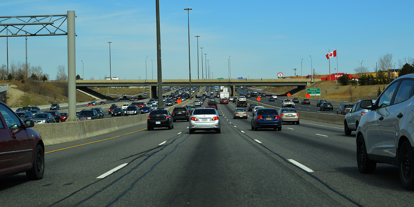
Шоссе №401 в Канаде состоит из 22 полос. Это магистраль, которая соединяет Онтарио и Квебек. Она известна также как King’s Highway 401, или Macdonald-Cartier Freeway.
Для основного движения задействовано 18 полос, и оставшиеся 4 используются как дополнительные съезды.
Кроме того, участок трассы, проходящий через Торонто, признан наиболее загруженным во всей Северной Америке: ежедневно по нему проезжает около 500 тыс. автомобилей.

Шоссе №401 в Канаде
(Фото: Craig Robertson/Globallookpress)
Лидерство Канады оспаривает Техас.
Дорога Katy Freeway, или Interstate 10, состоит из 18 полос. Но мэр города Хьюстон, через который проходит трасса, предлагает считать частью Katy Freeway еще 8 внешних по отношению к автостраде локальных дорог. Эти дороги идут параллельно основной магистрали и в сумме дают 26 полос. Однако техасское издание Poltifact, которое специализируется на проверке фактов, утверждает, что аргументы мэра необоснованны. Поэтому шоссе №401 по праву остается самой широкой в мире автодорогой.
Читайте также:
Какой была самая большая пробка?
Сколько автомобилей на планете?
До какой скорости может разогнаться автомобиль?
Шоссе в Онтарио
|
Шоссе 401 | |||
|---|---|---|---|
| Шоссе Макдональда — Картье | |||
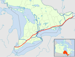 Шоссе 401 в Южном Онтарио Шоссе 401 в Южном Онтарио | |||
| Информация о маршруте | |||
| Поддерживается продавцом транспорта Онтарио | |||
| Длина | 828,0 км (514,5 миль) | ||
| История |
| ||
| Основные развязки | |||
| Уэст-Энд | Оджибвей-Паркуэй в Виндзор | ||
| |||
| Ист-энд | |||
| Местоположение | |||
| Крупные города | Виндзор, Лондон, Китченер, Кембридж, Миссиссога, Торонто, Ошава, Кингстон и Корнуолл | ||
| Система автомобильных дорог | |||
|


Королевс кое-что Шоссе 401, обычно называемое Шоссе 4 01, также известное под своим официальным названием как шоссе Макдональда — Картье или в просторечии четырехступенчатый, является управляемым доступом шоссе серии 400 в канадской провинции в Онтарио. Он простирается на 828 километров (514 миль) от Виндзора на западе до границы Онтарио и Квебека на востоке. Часть шоссе 401, проходящая через Торонто, является самой загруженной и одной из самых широких в Северной Америке. Вместе с Quebec Autoroute 20 он образует магистраль автомобильного транспорта Коридора Квебек-Сити — Виндзор, вдоль которого проживает более половины населения Канады. Это также основной маршрут в Национальной системе автомобильных дорог Канады. Маршрут обслуживает Министерство транспорта Онтарио (MTO) и патрулирует Полиция провинции Онтарио. Ограничение скорости составляет 100 км / ч (62 миль / ч) по всему его длине, за исключением исключения объявлено ограничение 80 км / ч (50 миль / ч) в западном направлении в Виндзоре и в большинстве строительных строительных.
К концу 1952 года отдельными шоссе были пронумерованы как шоссе 401: частично завершенная объездная дорога Торонто между Уэстон-роуд и шоссе 11 (Йонг-стрит); шоссе 2A между Вест-Хилл и Ньюкаслом ; и Живописное шоссе между Гананок и Броквиллем, теперь известное как Паркуй тысячи островов. Длина этих трех участков шоссе 11,8, 54,7 и 41,2 км (7,3, 34,0 и 25,6 миль) соответственно. В 1964 году маршрут стал полностью судоходным от Виндзора до границы Онтарио и Квебека. В 1965 году ему было присвоено второе название, шоссе Макдональда-Картье, в честь двух отцов Конфедерации. В конце 1968 года участок Гананок — Броквилл был объезжен, и конечный перекресток разделен по классам около Кингстон, что сделало шоссе 401 автострадой на всем его длине 817,9 км. 24 августа 2007 года участок шоссе между Глен Миллер Роуд в Трентон и Don Valley Parkway / Highway 404 Junction в Торонто был обозначен как Highway of Heroes, поскольку по дороге проходят похоронные конвои для погибших военнослужащих Канадских вооруженных сил от ЦФБ Трентон до офиса коронера в Торонто. 27 сентября 2013 года «Шоссе героев» было продано на запад до Кил-стрит в Торонто, что совпало с переездом коронера в новый комплекс судебно-медицинских служб и коронерского комплекса больницы Хамбер-Ривер.
В 2011 году началось строительство пристройки на запад, названной «Достопочтенный Херб Грей Бульвар». Этот новый маршрут следует, но не заменяет прежнее шоссе 3 между бывшим концом шоссе и E. Скоростная автомагистраль C. Row, в которой она поворачивает и ведет параллель к месту будущего Международный мост Горди Хау. 8-километровый (5 миль) бульвара к востоку от развязки EC Row был открыт 28 июня 2015 года, оставшийся участок был завершен и открыт 21 ноября. Летом 2019 года расширение шоссе между шоссе / региональной Дорога 8 в Китченере до шоссе / региональной дороги 24 в Кембридже до 12 полос движения была завершена. В настоящее время расширяются четырехполосные участки между Виндзором и Лондоном до шести полос и расширяются маршрут между Кембриджем и Милтоном, а также через Ошава. Обширная система с двенадцатью переулками «коллектор-экспресс», которая сейчас существует от Пикеринга через Торонто, частично через Миссиссога, и в настоящее время расширяется на запад через Миссиссогу до Милтона.
Содержание
- 1 Описание маршрута
- 1.1 Юго-западный Онтарио
- 1.2 Большой Торонто
- 1.3 Восточный Онтарио
- 2 Объем трафика
- 3 История
- 3.1 Предшественники
- 3.2 Допущение
- 3.3 Преимущество I-75
- 3.4 «Аллея бойни»
- 3.5 Шоссе героев
- 3.6 Проблемы безопасности и улучшения шоссе
- 3.7 Rt. Достопочтенный Herb Grey Parkway
- 4 Future
- 4.1 Юго-западный Онтарио
- 4.2 Большой Торонто
- 4.3 Восточный Онтарио
- 5 Услуги
- 6 Список выхода
- 7 См. Также
- 8 Пояснительные примечания
- 9 Ссылки
- 10 Общая библиография
- 10.1 Книги
- 10.2 Карты
- 11 Внешние ссылки
- 11.1 Официальные сайты
- 11.2 Фотографии и дополнительная информация
Описание маршрута
Шоссе 401 на Уэстон-роуд имеет объем более 500 000 автомобилей в день в течение летних месяцев, что делает его одним из самых загруженных участков шоссе в мире.
Шоссе 401 проходит через Юго-Западный, Центральный и Восточный Онтарио. В ожидании будущего расширения автомагистрали министерство транспорта приобрело полосу отчуждения шириной 91,4 метра (300 футов) по всей длине. Как правило, трасса занимает лишь часть этого участка. Это одна из самых загруженных автомагистралей в мире; анализ 2016 года показал, что среднегодовая посещаемость (AADT) между Weston Road и Highway 400 в Торонто составляла почти 420 000, в то время как второе исследование оценивает, что более В некоторые дни по этой участку проезжают 500 000 автомобилей. Это делает его самой загруженной в Северной Америке, превосходя шоссе Санта-Моника в Лос-Анджелесе и I-75 в Атланте. Своевременные системы доставки автозапчастей высокоинтегрированной автомобильной промышленности в Мичигане и Онтарио способствовали тому, что шоссе стало самым загруженным в мире маршрутом для грузовых автомобилей., на котором приходится 60 процентов автомобильной торговли между Канадой и США.
На шоссе 401 также находится загруженный многоэтажный мост в самой Северной Америке в Хоггс Холлоу в Торонто. Четыре моста, по два в каждом направлении с коллекторными и скоростными полосами, в 2006 году перевозили в среднем 373 700 автомобилей в день. Шоссе является одной из основных магистралей сети в районе Великих озер, соединяя густонаселенный Квебек — коридор Виндзор с Мичиганом, Нью-Йорком и коттеджным поселком в Онтарио. Это единое соединение между Торонто и Монреалем, становится Автострада 20 на границе Онтарио и Квебека.
Юго-западный Онтарио
Расширение шоссе 401 в Виндзор, открытый в 2015 году, представляет собой шестиполосную проезжую часть ниже уровня земли с туннелями и зелеными насаждениями. Он соединится с планируемым Международным мостом Горди Хау..
Шоссе 401 еще не простирается на последние несколько километров до Детройта; расширение до Брайтон-Бич (на границе Канады и США в Виндзоре) было завершено в ноябре 2015 года после чего Международный мост Горди Хау расширит шоссе 401 через границу Канады и США к соединению через Делрей с межштатной автомагистралью 75 в Мичигане до конца 2024 года. В настоящее время шоссе 401 начинается как автострада с шестью полосами движения в западном конце скоростной автомагистрали EC Row. На Дугалл Паркуэй шоссе поворачивает на восток и выезжает из Виндзора. Отсюда шоссе 401 в основном проходит через бывшую систему шоссе 98 от Виндзора до Тилбери.
Шоссе 401 расширяется до шести полос на шоссе 402 в Лондоне.
Юго-западный Онтарио — это равнинные земли, в основном сельскохозяйственные, которые используют плодородную глинистую почву, отложившуюся по всему региону. Главная река региона — река Темза, которая истощает второй по величине водораздел в южном Онтарио и в степени степени влияет на землепользование вокруг шоссе; Он проходит через север между Тилбери и Вудстоком.
Рядом с Тилбери шоссе 401 теряет свой высокий барьер посредине стены и сужается до четырех полос, следуя линиям участков, проложенным между концессионными дорогами в план разработан для ограничения ущерба безопасным сельскохозяйственным землям, через которые проходят автомагистраль. Здесь ровный и прямой маршрут шоссе известен тем, что ведет к невнимательности водителя. Участок от Виндзора до Лондона (особенно к западу от Тилбери ) стал известен смертоносными автомобильными авариями и скопления грузов, за что получил прозвище Carnage Alley. Когда шоссе приближается к Лондону, шоссе 402 сливается с ним, образуя шестиполосное поперечное сечение. В пределах Лондона он пересекает две муниципальные муниципальные скоростные автомагистрали, Хайбери-авеню и Бульвар Мемориала ветеранов.
. Участок между Лондоном и Вудстоком в целом параллелен бывшее шоссе 2, но пролегает на южной стороне реки Темзы. Этот район не такой ровный, но шоссе в целом прямое. Эта часть шоссе 401 часто испытывает сильные снегопады в начале зимы, иногда доходя до Торонто на востоке. К югу от Вудстока шоссе 401 поворачивает на северо-восток, а западная конечная остановка шоссе 403 сливается с ним. Отсюда шоссе направляется к Китченеру и Кембриджу, основной к северу от маршрута бывшего 2, поскольку шоссе 403 берет на себя роль параллельного бывшего шоссе 2 вплоть до Миссиссоги. В направлении Китченера шоссе пересекается с шоссе 8 и возвращается в восточную ориентацию. От шоссе / региональной дороги 8 до шоссе / региональной дороги 24 в Кембридже шоссе расширяется до 12 полос, чтобы приспособиться к большому объему движения, использует это шоссе 8, которое использует шоссе 401 и региональную дорогу 24 для передвижения между Китченером и Кембриджем. Эта 12-полосная секция открылась летом 2019 года; строительство на нем началось 8 июня 2015 года. За шоссе / региональной дорогой 24 шоссе возвращается к шестиполосному перекрестку и извивается в сторону Милтон, проходя по пути через холмы и скалы.
Район Большого Торонто
 шоссе 401 между шоссе 410 и 403 в Миссиссоге
  Камеры слежения за дорожным движением установлены на каждом выезде в Торонто и образуют одну часть система КОМПАС. «Корзинное полотно», к востоку от развязки шоссе 400, представляет собой плавный переход между коллекторной и экспресс-полосами.
По мере приближения шоссе 401 к району Большого Торонто (GTA) он спускается по экологически безопасному Ниагарскому откосу к западу от Милтона. Войдя в город, он входит в первую урбанизированную секцию GTA, проходя через две сельские территории между ней и Ошавой. Первый сельский пролом — это западная сторона Торонто Гринбелт, зона вокруг Торонто, защищенная от застройки. После этого 10 км (6,2 миль) шоссе переключается с шоссе 407 Express Toll Route. В пределах GTA шоссе проходит через несколько крупных торговых центров , включая торговый центр Yorkdale, центр города Скарборо и центр города Пикеринг.
шоссе 401 расширяется. в экспресс-систему по мере приближения к Mavis Road в Миссиссаге, концепция, вдохновленная Dan Ryan Expressway в Чикаго. Система разделяет каждое направление движения на коллекторные и скоростные полосы, давая шоссе широкий пролет и четыре проезжей части. Чтобы избежать путаницы между проезжими частями, используются синие знаки для полос коллектора и зеленые знаки для полос экспрессов. В отличие от коллекторных полос, которые обеспечивают доступ к каждой развязке, экспресс-полосы прямой доступ только к нескольким избранным развязкам. Доступ между ними обеспечивается трансферами, которые могут быть заблокированы для предотвращения сбоев, вызванных близко расположенными развязками. Общая цель коллекторно-экспресс-системы — максимизировать транспортный поток как для местных, так и для междугородних перевозок. Кроме того, в начале 1991 года шоссе 401 было оборудовано системой дорожных камер под названием COMPASS. С использованием камер видеонаблюдения, контуров обнаружения транспортных средств и светодиодных знаков с изменяемым сообщением, КОМПАС позволяет Центру управления дорожным движением получать в реальном времени оценку условий дорожного движения и предупреждать водителей о столкновениях, заторах и строительство. Система простирается от развязки шоссе 403/410 в Миссиссоге до Харвуд-авеню в Аяксе.
В GTA существует два набора систем экспресс-доставки. Первый набор имеет длину 6,6 км (4,1 мили) и соединяет шоссе 403, шоссе 410 и шоссе 427. Эта система в первую очередь служит для размещения различных транспортных потоков на шоссе 403/410 и шоссе 427 вдоль шоссе 401, заменяя более ранний план, по выбранному шоссе 403 велось бы напрямую до Эглинтон-авеню и никогда не построенные Скоростная автомагистраль Ричвью. К востоку от развязки с Renforth Drive полосы коллектора расходятся, превращаясь в съезды на шоссе 427 в северном и южном направлениях. Вторая система протяженностью 43,7 км (27,2 мили) проходит через центр Торонто и заканчивается в Пикеринге на востоке. Разрыв в 5 км (3,1 мили) между двумя системами является узким местом для движения транспорта. Тем не менее, развязка не может вместить будущее расширение шоссе 401.
шоссе 401 расширяется до 18 полос к югу от международного аэропорта Торонто Пирсон. Двигаясь на восток, восемь полос движения проходят под большим перекрестком спагетти на шоссе 427. Автострада изгибается на северо-восток и следует по коридору передачи электроэнергии до шоссе 409, которое сливается с магистралью и образует коллекторные переулки. Он возвращается на свой восточный маршрут через Торонто, в настоящее время по четырем проезжим частям проезжает 12–16 полос движения. Шоссе 401 часто перегружено на этом участке: по состоянию на 2008 год между Уэстон-роуд и шоссе 400 в день проезжало в среднем 442 900 транспортных средств. Несмотря на эту загруженность, это основной маршрут в Торонто; более 50 процентов транспортных средств, направляющих в центр Торонто, используют шоссе.
На знаках системы экспресс-доставки на шоссе 401 используются разные цвета, чтобы избежать путаницы. На скоростных переулках используются зеленые знаки, а на переулках для сборщиков — синий.
К востоку от шоссе 400 находится «Баскетвив», перекрестный транспортный узел между проезжей частью экспрессов и сборщиков, за которым находится Йоркдейл-центр. Двенадцать полос проходят под сложной развязкой с Allen Road, построенной для отмененной Скоростной автомагистрали Спадина. Дальше на восток шоссе пересекает Лощину Хогга, проходит через реку Западный Дон и улицу Йонг-стрит в центре Торонто, самый оживленный многопролетный мостовой переход в Северной Америке, превосходящий Бруклинский мост. Затем он пересекает реку Восточный Дон и поднимается в сторону Don Valley Parkway, которая обеспечивает доступ к центру Торонто, и шоссе 404, которое обеспечивает доступ к пригородам для север. Двигаясь на восток, шоссе продолжается в основном через жилые районы Скарборо, в конечном итоге достигая долины Руж на восточной окраине города и переходя в Пикеринг.
к западу от Пикеринга, снова встречается с бывшим шоссе 2, которое обычно проходит параллельно с ним. граница Онтарио и Квебека. Когда шоссе приближается к Брок-роуд в Пикеринге, коллекторная и экспресс-полосы сходятся, сужая поперечное сечение с 14 полосами до 10, разделенных только в центре. Эта ширина сохраняется, поскольку он переходит в Ajax, прежде чем сузиться до шести полос на Салем-роуд. Планируемое расширение к востоку от Салема для улучшения потока, ведущего к развязкам шоссе 412 и Лакеридж-роуд, приведет к расширению шоссе до десяти полос до Брок-стрит в Уитби, где существующая развязка будет реконфигурирована.
К востоку от Аякса шоссе проходит через второй 3,5 км (2,1 мили) сельский пролом и входит в Уитби. На участке шоссе 401 через Уитби и Ошава есть несколько построек, построенных во время первоначального строительства в 1940-х годах. Некоторые из этих построек должны быть снесены либо из-за их возраста, либо для подготовки к запланированному расширению шоссе 401 через этот район. Бывший путепровод Канадской национальной железной дороги, который был огорожен забором, но обычно использовался пешеходами во время репатриации «Шоссе героев», был снесен ночью 11 июня 2011 года. Второе строение в Боуменвилле было снесено во время двух ночных закрытий. 9 и 16 июля. На Хармони-роуд пригород быстро переходит в сельскохозяйственные угодья. Шоссе огибает южную сторону Bowmanville и ведет к Highway 35 и Highway 115.

Highway 401 в центре Торонто; Вдали виден горизонт Северного Йорка.

Пробка на шоссе 401 к востоку от Торонто.

Самый широкий сегмент автомагистрали 401 состоит из 18 сквозных полос, он расположен рядом с международным аэропортом Торонто Пирсон
Восточный Онтарио
На большей части восточного Онтарио шоссе 401 представляет собой сельскую автостраду с травой медиана.
С востока от шоссе 35 и 115 до Кобург шоссе 401 проходит через смесь сельскохозяйственных угодий и лесов, сохраняя прямой курс. К востоку от Кобурга шоссе сужается до четырех полос, а местность становится холмистой, шоссе проходит вокруг холмов и через долины вдоль берегов озера Онтарио. В Трентон шоссе пересекает Трент-канал и возвращается в сельскохозяйственные угодья. Затем он пересекает реку Мойра, проходит через Бельвиль, прежде чем отправиться на восток в Кингстон. Кингстонский участок шоссе, первоначально называвшийся Kingston-Bypass, был одним из первых участков шоссе, которые должны были быть завершены; Сейчас это в основном три полосы в каждую сторону.
К востоку от Кингстона шоссе продолжается через преимущественно сельскохозяйственный район вдоль реки реки Святого Лаврентия до Гананока, где она разделяется на Паркуй тысячи островов, одну из Первоначальные участки шоссе были обозначены в 1952 году. Текущее шоссе 401 проходит параллельно бульвару в нескольких километрах от берега реки. Канадский щит, древнее геологическоеобразование, появляется через этот густо заросший лесом участок шоссе. Шоссе 401 присоединяется к бульвару Тысячи непосредственно к юго-западу от Броквилля, теперь направляется на северо-восток.
Остальная часть шоссе проходит по течению бывшего шоссе 2 вдоль берега реки Святого Лаврентия в пределах Долина Святого Лаврентия. К северо-востоку от Броквилля находится развязка с шоссе 416, ведущим на север к Оттаве. На границе Онтарио и Квебека шоссе 401 становится автострадой 20 и продолжается до Монреаля.
Объем трафика
MTO публикует годовые данные об объеме трафика для провинциальных автомагистралей, выраженные как среднесуточное количество транспортных средств за размах в году (AADT). В таблице ниже сравнивается AADT в точках вдоль шоссе 401 с данных за 1969, 1988, 2008 и 2016 годы.
| Местоположение | Виндзор | Лондон | Вудсток | Кембридж | Миссиссога | Торонто | Ошава | Бельвиль | Кинг | Броквилл | Корнуолл | |
|---|---|---|---|---|---|---|---|---|---|---|---|---|
| Секция | Дугалл Паркуэй -. Эссекс Каунти Роуд 46 | Хайбери Авеню -. Veterans Memorial Parkway | Oxford County Road 59 -. Highway 403 | Highway 8 -. Highway 24 | Mississauga Road -. Hurontario Street | Weston Road -. Шоссе 400 | Стивенсон-роуд -. Симко-стрит | Шоссе 62 -. Шоссе 37 | Фронтенак Каунти-роуд 38 -. Сиденхэм-роуд | шоссе 29 -. Норт-Огаста-роуд | шоссе 138 -. McConnell Avenue | |
| Объем трафика (AADT ) | 1969 | 9,550 | 17,450 | 16,700 | 19,900 | 28,450 | 106,850 | 29,000 | 13,750 | 12,000 | 10,050 | 10,300 |
| 1988 | 13,200 | 33,800 | 35,100 | 50,400 | 97,100 | 319,600 | 79,000 | 22,500 | 20,700 | 15,300 | 12,900 | |
| 2008 | 16,700 | 64,500 | 67,100 | 125,600 | 177,300 | 442,900 | 120,700 | 43,500 | 45,400 | 29,100 | 18,400 | |
| 2016 | 17,500 | 64,200 | 67,500 | 137,300 | 216,500 | 416,500 | 134,200 | 45,300 | 55,000 | 33,600 | 21,400 | |
| Среднегодовое ежедневное Учет трафика на выбранных участках шоссе 401 за 47 лет |
| Местоположение | Скоростная автомагистраль EC Row до шоссе округа Эссекс 42 | Дорога округа Эссекс 42 до шоссе 402 | шоссе 402 к западу от Гуронты Рио-стрит | К западу от улицы Хуронтарио до шоссе 403/410 | шоссе 403/4 1 0 до шоссе 427 | с шоссе 427 до шоссе 27 | с шоссе 27 до Шоссе 409 | Шоссе 409 до Брок-роуд | Брок-роуд к Салем-роуд | Салем-роуд до 4,5 км к востоку от Балтимор-стрит | в 4,5 км к востоку от Балтимора От улицы до Frontenac County Road 38 | Frontenac County Road 38 до Montreal Street | Montreal Street до границы ON — QC |
|---|---|---|---|---|---|---|---|---|---|---|---|---|---|
| Количество переулков | 6 полос | 4 полосы | 6 полос | 10-полосная коллекторно-экспресс-система | 18-полосная коллекторно-экспресс-система | 8 полос | 10 полос | 12–16-полосная коллекторно-экспресс-система | 10 полос | 6 полос | 4 полосы | 6 полос | 4 полосы |
| Расстояние | 55,7 км (34,6 мили) | 127,5 км (79,2 мили) | 157,7 км (98, 0 миль) | 3,6 км (2,2 мили) | 5,8 км (3,6 мили) | 0,8 км (0,50 мили)) | 3,9 км (2,4 мили) | 43,3 км (2 6,9 мили) | 6,0 км (3,7 мили) | 74,8 км (46,5 мили) | 131,7 км ( 81,8 мили) | 8,2 км (5,1 мили) | 209,0 км (129,9 миль) |
| Количество проходных полос на шоссе 401 (исключая текущие или планируемые проекты расширения) |
История
Предшественники
Автомагистраль 401 имеет цветовую маркировку по году открытия каждого участка для движения транспорта
История шоссе 401 предшествует обозначению более чем на два десятилетия. В начале 20 века проектирование и строительство дорог значительно продвинулись вперед. После частой эрозии Лейк-Шор-роуд, затем покрытой щебнем, в январе 1914 года была предложена бетонная дорога, известная как шоссе Торонто-Гамильтон. Строительство началось 8 ноября того же года, после начала World Первая война. Шоссе было спроектировано так, чтобы оно проходило вдоль берега, а не Дандас-стрит на севере, потому что многочисленные холмы, встречающиеся вдоль Дандаса, увеличили бы расходы без улучшения доступности. Миддл-роуд, грунтовая дорога, названная так из-за ее положения между ними, не рассматривалась, поскольку Лейк-Шор и Дандас были переполнены и нуждались в серьезном ремонте. Дорога была официально открыта 24 ноября 1917 года, ширина ее 5,5 м (18 футов), длина — почти 64 км (40 миль). Это была первая бетонная дорога в Онтарио, а также один из самых отрезков бетонной дороги между длинными городами в мире.
В течение следующего десятилетия использование транспортных средств значительно увеличилось, и к 1920 году Лейкшор-роуд снова был перегружен, особенно в выходные дни. В ответ Департамент автомобильных дорог рассмотрел вопрос об улучшении другой дороги между Торонто и Гамильтоном. Дорога должна быть более чем в два раза шире Лейкшор-роуд и составлять 12 м (39 футов) и обеспечивать две полосы движения в обоих направлениях. Строительство того, что тогда называлось Расширение Куин-Стрит к западу от Торонто, началось в начале 1931 года.
Прежде чем строительство шоссе могло быть завершено, Томас МакКуэстен был назначен новым министром Департамента автомобильных дорог с Робертом Мелвиллом Смитом в качестве заместителя министра после провинциальных выборов 1934 года года. Смит, вдохновленный немецкими автобанами — новыми «двухполосными разделом шоссе » — изменил конструкцию дорог Онтарио, и МакКвестен приказал превратить Мидл-роуд в эту новую формулу.. 40-метровая (130 футов) полоса отвода была куплена вдоль Средней дороги, и началось строительство по преобразованию участков в разделенную автомагистраль. Также начались работы по строительству первой развязки в Канаде на шоссе 10.
Бывшее шоссе 2A около Хайленд-Крик, за исключением восстановленного тротуара, не менялось с момента открытия в 1947 году.
Начало с 1935 года. МакКвестен применил концепцию двухмагистральной магистрали к нескольким проектам вдоль шоссе 2, в том числе вдоль Кингстон-роуд в районе Скарборо. Когда в 1936 году расширение в Скарборо достигло ущелья Хайленд-Крик Департамент автомобильных дорог начал строительство нового моста через большую долину в обход бывшего вокруг Вест-Хилл. Отсюда шоссе было построено на новом участке дороги в Ошава, чтобы избежать строительства на перегруженном шоссе 2. Город класс и строительство моста на новом шоссе между Вест-Хиллом и Ошавой в сентябре 1939 г. приближались к завершению, Разразилась Вторая мировая война.
В то же время, с 6 по 8 сентября 1939 года конференция проходила в Bigwin Inn, около Хантсвилля, привлекая дорожных инженеров со всей Северной Америки, обсудить новую концепцию «чтобы двойных магистралей». В первый день съезда МакКестен объявил о своем видении автострады: непрерывное движение по живописным регионам Онтарио, препятствующее движению по шоссе местным предпринимателям и местному транспорту, за исключением редких точек контролируемого доступа. Через несколько дней было объявлено, что эта концепция будет применена к новой «межпровинциальной скоростной автомагистрали», идущей от Виндзора до границы Онтарио и Квебека.
Инженеры автомагист оценили такие факторы, как уклон, радиус кривой и узкая середина, использовавшаяся вдоль Средней дороги, которая была открыта 23 августа 1940 года как Уэй Королевы Елизаветы (QEW), и начала планировать курс новой двойной автомагистрали, в основном параллельной шоссе 2, с приоритетом отдается районам, наиболее подверженной перегруженности. В отличие от QEW, эта автомагистраль будет построена не вдоль существующей дороги, а скорее на новой полосе отвода, что позволит избежать необходимости обеспечения доступа к собственности.
Наряду с огромными улучшениями в технике и строительной технике. В течение шести лет дала плановикам возможность провести опрос 375 000 водителей, спросив их о предпочтительном маршруте движения к месту назначения. Используя эту информацию, был проложен курс от Виндзора до Квебека, минуя все города по пути.
Шоссе 2S (S означает Живописный) было первым завершенным участком новой дороги. Построенная для соединения с Мостом Тысячи островов на Айви-Ли и открытая в гравийной дороге в конце 1941 или начале 1942 года, дорога шла вдоль берега реки Святого Лаврентия и соединялась с западным концом сдвоенного шоссе 2 возле Броквилля. Кроме того, в мае 1942 года шоссе между Хайленд-Крик и Ошава было открыто как дорога с гравийным покрытием.
После войны строительство дорог возобновилось по всему Онтарио. Скоростная автомагистраль между Хайленд-Крик и Ошава была завершена в декабре 1947 года, в то время как другие участки зачахли. В то время шоссе Торонто-Барри было основным направлением деятельности Департамента автомобильных дорог, и начало Корейской войны в 1950 году снова остановило строительство. Несмотря на задержку, министр автомобильных дорог Джордж Дусетт официально объявил о планах строительства в этом году новой межпровинциальной скоростной автомагистрали, при этом скоростная автомагистраль Торонто — Ошава послужит образцом для проекта. Работа над самым важным звеном, объездной дорогой Торонто, началась в 1951 году, но она не открывалась с таким названием.
 Щиты автострады Макдональда — Картье когда-то были обычным явлением на всей трассе, но не были заменены, поскольку с возрастом они плохались.
Предположение
Развязка шоссе 400 в 1953 году. Сегодня бывшая клеверный лист был заменен многоуровневой развязкой. Расширение 401 с до четырех двенадцати полос в Торонто заняло девять лет, и при этом по крайней мере четыре полосы были открыты постоянно. Здесь показано шоссе 401 / Don Valley Parkway / Highway 404 развязка, строительство которой велось в 1965 году. Через годы после открытия объездной дороги Торонто с четырьмя полосами движения было перегружена, что привело к Департаменту шоссейных дорог расширит этот участок до 12 полос, начиная с 1963 года. Шоссе 401 на Медоувейл-роуд в 1989 году, прежде чем было расширено до 14-полосной системы экспресс-сборщиков.
В июле 1952 года (возможно, 1 июля, то же самое время шоссе 400 было пронумеровано), скоростная автомагистраль от Хайленд-Крик до Ошава и шоссе 2S были обозначены как шоссе с контролируемым доступом № 401, что отвергалось одним критиком из- за то, что пронумерованное название не задумывалось. Завершено строительство нескольких участков объездной дороги Торонто: между шоссе 400 и Дафферин-стрит в августе, на западе до Уэстон-роуд в сентябре, на востоке до Батерст-стрит в октябре и, наконец, до Йонг-стрит в декабре. Расширение на восток и запад началось в 1953 году; восточное продолжение Бэйвью-авеню открылось в апреле 1955 года, но западное расширение было отложено из-за ущерба, нанесенного ураганом Хейзел 15 октября 1954 года, который почти разрушил новый мост через реку Хамбер. Реконструкция продлилась до 8 июля 1955 года, и в сентябре 1955 года было открыто шоссе между Вестоном и шоссе 27.
Весь объездной путь, включая расширение шоссе 27 на скоростную автомагистраль к югу от шоссе 401, был завершен. в августе 1956 года. После открытия объездная дорога была описана одним репортером как «мечта автомобилиста», обеспечивающая «одни из самых успокаивающих пейзажей в столичном районе». Относительно восточного участка через Скарборо репортер продолжил, что он «плавно петляет по пастбищам, ручьям и рекам, а также среди зеленых зарослей. Кажется, далеко от большого города». К 1959 году объездная дорога представляла собой ряд автомобилей, так как 85 000 водителей заполнили проезжую часть, рассчитанную на то, чтобы ежедневно обслуживать не более 48 000 автомобилей. Автомобилисты сочли новую дорогу удобным способом передвижения по Торонто; это удобство помогло повлиять на смену пригородов в городе и продолжает быть движущей силой разрастания городов сегодня.
Между тем за пределами Торонто шоссе строилось лоскутным способом с упором в первую очередь на перегруженных участках. Строительство к западу от шоссе 27 началось в конце 1954 года, как и объездная дорога Кингстон в Восточном Онтарио. Работы по соединению последнего с Scenic Highway начались в 1955 году. После того, как в 1954 году New York State Thruway открылась от Buffalo до New York City, официальные лица штата Мичиган поддержали Онтарио обойти шоссе 3 как самый прямой путь из Детройта в Буффало. К 1956 году началось строительство участка между шоссе 4 в Лондоне и шоссе 2 в Вудстоке, а также на участке между Виндзором и Тилбери.
Мемориальная доска возле Броквилля знаменует официальное завершение строительства шоссе.
В В 1958 году был открыт участок в обход Моррисберга для размещения транспортных средств, перемещенных с участка шоссе 2 через Затерянные деревни морского пути Святого Лаврентия. В конечном итоге шоссе 2 будет вновь открыто на новой трассе, которая будет следовать за полосой отчуждения железной дороги CN.
К концу 1960 года участок шоссе Торонто был продлен как на восток, так и на запад: сначала 30 июня на восток между Ньюкаслом и Порт-Хоупом, а затем на запад между шоссе 25 в Милтоне и Шоссе 8 к югу от Китченера 17 ноября. К середине 1961 года участок между Брайтоном и Мэрисвиллом открылся. Разрыв на восток, от шоссе 28 в Порт-Хоупе до шоссе 30 в Брайтоне, был открыт 20 июля 1961 года.
Разрыв между Вудстоком и Китченером был завершено 9 ноября 1961 года, в то время как разрыв между Тилбери и Лондоном был завершен двумя полосами движения в то время; переулки в северном направлении — 22 октября 1963 года, южные — 20 июля 1965 года. Разрыв между Мэрисвиллом и Кингстоном был открыт к 1962 году. Последние участки, от западного Корнуолла до Ланкастера, были открыты между 1962 и 1964 годами; две полосы открылись в Ланкастер 11 сентября 1962 года, но две другие были завершены только 31 июля 1964 года. Последний отрезок, ведущий к границе Онтарио и Квебека, был открыт 10 ноября 1964 года. Наконец, 11 октября 1968 года открыт объезд Тысячи островов. Этот последний фрагмент был отмечен мемориальной доской, означающей завершение строительства шоссе 401.
В Торонто инженеры и геодезисты изучали объезд с четырьмя полосами движения, в то время как проектировщики приступили к проектированию способом управления пригородным шоссе. В 1963 году министр транспорта Чарльз Макнотон объявил о расширении шоссе 401 в Торонто с четырех до минимум 12 полос между Ислингтон-авеню и Маркхэм-роуд. Она была расширена до аналогичной конфигурации в то же время. Строительство началось немедленно. Первоначально по плану строительство предполагалось завершить в 1967 году, но оно продолжалось почти десятилетие. По крайней мере, четыре полосы движения всегда были открыты во время большого проекта реконструкции, который включал сложные новые развязки на шоссе 27, шоссе 400, планируемой скоростной автомагистрали Спадина и бульваре Дон Вэлли. Система была завершена в 1972 году вместе с объездной автомагистралью 27 (переименованной на шоссе 427) между QEW и аэропортом Пирсон. Большинство транспортных развязок в Торонто были реконструированы как частичные клеверные листья, и была установлена система постоянного освещения.
11 января 1965 года, на ужине сэра Джона А. Макдональда. исполнилось 150 лет, премьер Онтарио Джон Робартс назначил шоссе 401 автострадой Макдональда-Картье в честь Макдональда и Джорджа-Этьена Картье, двух канадских отцов. Конфедерации. В отличие от других названий, которые позже применялись к шоссе, обозначению шоссе Макдональда — Картье охватывает всю ширину шоссе 401. Были установлены знаки, обозначающие шоссе, и щиты с буквами «MC», но они были удалены к 1997 году. В 2003 году 38 спустя годы после того, как Робартс назвал шоссе, член парламента провинции попытался закрепить в законе название шоссе Макдональд-Картье; законопроект прошел только первое чтение и не был принят.
В 1970-х годах шоссе 401 было расширено до шести полос движения в Дареме, но в остальном мало улучшилось. В 1980-х годах было расширено больше участков, а также была построена новая коллекторно-экспресс-система между шоссе 403/410 и шоссе 427, завершенная в середине 1985 года. Планировалось расширить восточную систему от Нилсон-роуд до Брок-роуд в Пикеринге в конце 1980-х, но потребовалось более десяти лет, чтобы реализовать их в 2000 году. Вскоре за этим последовало расширение шоссе через Аякс и новая развязка на Пикеринг-Бич-роуд (переименованная в Салем-роуд) и Стивенсон-роуд.
В 1990-е годы также был сделан первый шаг в расширении шоссе до шести полос от Торонто до Лондона. Проект середины 1990-х годов увеличил количество полос между шоссе 8 в Китченере и шоссе 35/115 в Ньюкасле до минимум шести полос движения. Другие проекты подготовили участки для возможного расширения.
В 1993 году на участке шоссе 401 в восточном направлении возле Милтона и в западном направлении возле Уитби были нарисованы шевроны на каждой полосе, чтобы уменьшить заторможенность, концепция заимствована из Франции и Великобритании. Знаки советовали автомобилистам держать по крайней мере шеврона друг от друга, по сути предупреждая их не следовать слишком два шеврона. Были удалены некоторые из этих шевронов оставлены нетронутыми на западных полосах движения в Уитби до 2012 года, хотя знаки, указывающие их на использование, были удалены.
С 1998 года, на шоссе 401 в Торонто было начато несколько проектов. К ним добавление одной полосы через развязку на шоссе 427 в 2005 году, а также обновление покрытия тротуара в городе.
В 2018 году были завершены последние съезды на развязке на шоссе 403 и 410 в Миссиссаге, обеспечение полного доступа к ранее частичной развязке.
Advantage I-75
В период с июня 1990 по 1998 гг. шоссе 401 и Interstate 75 использовались для пилотного проекта под названием Advantage I. -75 для проверки надежности и универсальности автоматизированной системы слежения за грузовыми автомобилями. Называемая «MACS» (Автоматизированная система оформления), она позволяет грузовику перемещаться из Флориды в Онтарио без повторного осмотра. Первоначально MACS был протестирован на двух станциях техосмотра грузовиков в Кентукки, при этом транспондеры были установлены на 220 грузовиках. Точное время, дата, местоположение, вес и данные по осям регистрировались при приближении грузовика к установке станции. После первоначальных испытаний система MACS развернута на каждой инспекционной станции на трассе I-75 от Майами до Детройта и вдоль шоссе 401 от Виндзора до Бельвилля в 1994 году. Проект эффективности электронных систем в условиях ограничения грузовых перевозок без задержки транспортных средств при одновременном снижении безопасности опасается, что такие системы могут быть скомпрометированы. С тех пор эта концепция была применена во многих частях Канады, в том числе в электронной плате за плату за проезд на шоссе 407.
«Переулок бойни»
3 сентября 1999 года скопилось 87 автомобилей.
Участок шоссе 401 между Виндзором и Лондоном часто называют Аллеей резни в связи с многочисленными авариями, которые произошли на протяжении всей его истории. Этот стал более распространенным после нескольких смертоносных скоплений в течение 1990-х годов. Узкая и открытая середина травы была неэффективным препятствием для предотвращения столкновений между ними. мягкие обочины состояли из гравия с крутыми склонами, которые считались, способствовали опрокидыванию транспортных средств. Характер этого участка шоссе, описываемого как в основном прямая дорога с невыразительным сельскохозяйственным ландшафтом, заставляет водителей чувствовать себя менее вовлеченными и терять внимание к. Зимой в районе между Вудстоком и Чатемом также случаются внезапные снежные шквалы из-за снежного эффекта озера. Несколько столкновений произошли в результате того, что автомобилисты отклонились от своей полосы движения и потеряли контроль над своими автомобилями.
Некоторое время использовались различные другие названия, в том числе The Killer Highway, но Carnage Alley стала преобладающей после скопления 87 -up 3 сентября 1999 года (начало выходных Дня труда ), худшего в истории Канады, в результате которого восемь человек погибли и 45 получили травмы.
Только несколько За несколько дней до этого тогдашний министр транспорта Дэвид Тернбулл счел шоссе «приятным» для вождения. Утром 3 сентября местная метеостанция сообщила о ясных погодных условиях из-за неисправности, когда на шоссе накатился толстый слой тумана. Десятки автомобилей, в том числе несколько полуприцепов, быстро в друге вскоре после 8 часов утра, один за другим в густом тумане, скопившиеся обломки застряли в потоке машин, движущихся в противоположном направлении. Сразу после аварии МТО установило мощеные обочины с грохотом и профинансировало дополнительные полицейские для патрулирования шоссе, что критиковали как недостаточное.
Начиная с 2004 года., 46 км (29 миль) шоссе было расширено с четырех асформированных полос до шести бетонных полос, были добавлены мощеные обочины, установлена бетонная медиана высокой стены Онфальтарио, что было решением, продвигаемым Канадской автомобильной ассоциацией в 1999. Были улучшены развязки и модернизированы вывески в рамках пятиэтапного проекта по улучшению шоссе 401 от шоссе 3 в Виндзоре до дороги округа Эссекс 42 (ранее шоссе 2) на западной окраине Тилбери.
Шоссе Героев
Линия канадцев пересекает Шоссе Героев, чтобы отдать дань уважения павшим солдатам. Маркер маршрута Шоссе Героев
24 августа 2007 г. объявил об участке шоссе 401 между Глен Миллер Роуд в Трентоне и перекрестком е. Трасса Дон Вэлли и шоссе 404 в Торонто будут носить дополнительное название «Шоссе героев» (французский: Autoroute des héros) в честь погибших канадских солдат, хотя шоссе 401 в целом остается обозначенным как шоссе Макдональда-Картье. По этой длине шоссе часто проезжает конвой транспортных средств, перевозящих тело упавшего солдата с его семьей, от ЦФБ Трентон до офиса коронера в Центре судебной медицины. в Торонто. С 2002 года, когда первые павшие канадские солдаты были репатриированы из Афганистана, толпы выстроились вдоль переходов с до в знак уважения по мере прохождения конвоев.
Происхождение названия можно проследить до статьи в Toronto Sun от 23 июня 2007 года обозревателя Джо Уормингтона, в котором он брал интервью у фотографа Нортумберленда Пита Фишера. Житель Кобурга Рон Флиндалл отвечал за организацию первых салютов на мосту после гибели четырех солдат 18 апреля 2002 года.
Уормингтон описал скопление толпы на эстакадах, чтобы приветствовать павших солдат, как «явление шоссе героев».. Это привело к тому, что пожарный-волонтер Крамах Тауншип 10 июля связался с Фишером по поводу подачи петиции, что побудило Фишера опубликовать статью, которая была размещена на веб-сайте Northumberland Today. Интернет-статья в конечном итоге привлекла внимание жителя Лондона Джея Форбса. Forbes начал петицию, которая собрала более 20 000 подписей, прежде чем была доставлена министру транспорта 22 августа. После объявления от 24 августа правительство провинции и MTO приступили к разработке новых знаков. Знаки были установлены и открыты 7 сентября и включает меньший маркер подтверждения (щит), а также увеличенный рекламный щит.
Проблемы безопасности и улучшения шоссе
Шоссе 401 был расширен в 2008 году между шоссе 402 и Веллингтон-роуд в Лондоне. Планируется дополнительное расширение к западу от шоссе 402. Шоссе 401 было закрыто во время серии взрывов пропана в Торонто в 2008 году, что позволяет сделать эту редкую 14-полосное шоссе, занятого одним транспортным средством.
10 августа 2008 г. после взрывов на предприятии по производству пропана в Торонто в качестве меры предосторожности было перекрыто шоссе 401 между шоссе 400 и 404, крупнейшее закрытие шоссе в его история. Шоссе осталось закрытым до 8 часов вечера, хотя несколько съездов возле места взрыва оставались закрытыми после этого.
В период с 2006 по 2008 год шоссе 401 было расширено с четырех до шести полос между шоссе 402 и Веллингтон-роуд В Лондоне. Это включало замену оригинального путепровода Веллингтон-Роуд. В Ошаве выезд 416 (Park Road) был заменен новой развязкой на выходе 415 (Stevenson Road). Контракт, который начался 7 сентября 2005 г., включал в себя замену и ремонт 23,4 км (14,5 миль) шоссе между Ошава и шоссе 35 / шоссе 115. Пандусы в западном направлении были открыты в середине сентября 2007 г., а пандусы в восточном направлении — в середина 2009 г. Ремонт был завершен в середине 2010 года.
В ноябре 2010 года после многих лет планирования и строительства было завершено расширение шоссе 401 с четырех до шести полос между полосами Вудстоком и Китченером. Проект включал установку срединного барьера с высокими стенами, выпрямление кривых и добавление дополнительных развязок на автостраде, что позволяет бы легко освободить ее в случае аварии.
Рт. Достопочтенный Herb Gray Parkway
В 2004 году совместное заявление федерального правительства Соединенных Штатов и правительства Канады подтвердило, что новый пограничный переход будет построен между Детройтом и Виндзором. Международный переход через реку Детройт (DRIC) был сформирован как двухнациональный комитет для управления проектом. MTO воспользовалось этой возможностью, чтобы продлить шоссе 401 до границы между Канадой и США, и в конце 2005 г. начало оценка воздействия на всю среду для всего проекта. Город Виндзор также нанял консультанта по вопросам дорожного движения в Нью-Йорке Сэм Шварц спроектировал бульвар к границе. Предложение Шварца в конечном итоге привлекло DRIC на создание собственной конструкции, но его маршрут не был выбран, и вместо этого DRIC выбрал северный маршрут. 8 февраля 2008 г. MTO объявило о начале покупки недвижимости к югу от скоростной автомагистрали EC Row Expressway, что расстроило многие жители района, которые приобрели недвижимость в предыдущие годы.
3 марта 2008 г. Министерство транспорта штата Мичиган и MTO (в партнерстве с Министерство транспорта Канады, Федеральным управлением шоссейных дорог США и группой Detroit River International Crossing) завершили совместную оценку почвы вдоль реки Детройт и определили, что они действительно могут выдержать вес нового моста; стабильность подстилающего грунта и глины, а также воздействие близлежащих Виндзорской соляной шахты вызвали обеспокоенность всех сторон, участвующих в проекте.
Несмотря на протесты жителей, а также отклонил иск от Амбассадор Бридж, владелец Мэтти Моруна, 1 мая 2008 г. было объявлено, что выбран предпочтительный маршрут, и новый маршрут будет называться Windsor-Essex Parkway. Новый бульвар ниже уровня земли с шестью полосами движения. Он следует (но не заменяет) Талбот-роуд и Гурон-Черч-роуд от новой развязки на бывшем конце шоссе 401 до скоростной автомагистрали EC Row, где он проходит одновременно в западном направлении на 2 км (1,2 мили). Оттуда он поворачивает на северо-запад и следует новой трассе к границе. Внутри новый бульвар получил номер Шоссе 7901.
Первоначальное строительство шумового барьера от North Talbot Road до Howard Avenue началось в марте 2010 года; полное строительство началось 19 августа 2011 года.
28 ноября 2012 года Министерство транспорта объявило Федеральный приказ в Совете об изменении названия бульвара на «Rt Достопочтенный Херб Грей Бульвар» в честь Достопочтенного Херба Грея, члена парламента автомагистрали из Виндзора. В начале 2015 года было объявлено, что бульвар будет открыт для улицы 3 и улицейелль (около скоростной автомагистрали EC Row) весной; 8-километровый участок (5 миль) 21 ноября был открыт для движения 28 июня, расширяя шоссе 401 на запад до скоростной автомагистрали EC Row, и он был открыт после объезда Тысячи островов в 1968 году, 21 ноября был открыт участок до Оджибвей Паркуэй, завершивший бульвар до запланированного подхода. Консорциум «Соединяя Северную Америку» был выбран для строительства моста, началось в 2015 году с первоначальной датой завершения в 2019–2020 годах. в июле 2018 года. Незначительное строительство началось немедленно, а основное строительство началось осенью 2018 года. Ожидается, что международный мост Горди Хау будет завершен к концу 2024 года.
Будущее
Участок автомагистрали 401 в Большом Торонто в последние годы сильно застраивался.
Юго-Западный Онтарио
В Юго-Западном Онтарио проводит ряд улучшений, чтобы обеспечить шесть переулков на шоссе 401 из Виндзора в Торонто, в ответ на аварию на шоссе 401 в 1999 году в Carnage Alley. К западу от дороги округа Эссекс 42 на западе Тилбери, шоссе было расширено до шести полос с бетонным разделителем в ожидании Рт. Достопочтенный Herb Grey Parkway.
Ожидается, что в районе Лондона интенсивность движения значительно увеличится, что приведет к ухудшению состояния шоссе. Провинция разработала обширный план по расширению и реконструкции лондонского коридора в период с 2006 по 2021 год. Это включало строительство новой развязки с Wonderland Road, которая открылась в ноябре 2015 года для улучшения доступа к шоссе 401 в западном направлении от юго-западной оконечности города и включил замену эстакады Вестминстер-Драйв, чтобы расширить шоссе. Также предлагается реконструкция устаревшей развязки клеверного листа на Colonel Talbot Road и расширение шоссе 401 с четырех до шести полос между 4 и расширением шоссе 402. 401 с шести до восьми полос через часть лондонского коридора.
В районе Китченера / Кембриджа расширение шоссе от шоссе / региональной дороги 8 до шоссе / региональной дороги 24 был завершен летом 2019 года. Затем необходимо затем реконструировать развязку между шоссе 401 и шоссе 8, чтобы он стал полностью разветвленной развязкой, позволяющей движение по шоссе 401 в восточном направлении пересекать шоссе 8 (в направлении Китченера) и шоссе в южном направлении. 8 движение по шоссе 401 в западном направлении (в сторону Лондона). В какой-то момент в будущем планируется расширить шоссе к востоку от шоссе / региональной дороги 24.
Район Большого Торонто
шоссе 401 в Гринбелте. Участок шоссе 401 между шоссе 8 и шоссе 407 ETR планируется расширить с шести до десяти полос, включая две полосы движения HOV.
В плане 2007 года для южного Онтарио., MTO объявило о долгосрочных планах по созданию возможностей движения для автомобилей с высокой вместимостью (HOV) от Миссиссауга-роуд на запад до Милтона; к 2011 году масштабы этих планов были расширены до западного района Хеспелер-роуд в Кембридже.
Шоссе. Работы по расширению 401 в Миссиссауге, если смотреть со стороны Миссиссауга-роуд в 2020 году
К 2014 году строительство было завершено по расширению шоссе 401 до коллекторно-экспресс-системы от 403 и шоссе 410 к западу от улицы Хуронтарио, на расстоянии 2,8 км (1,7 мили). Близится к завершению строительство по расширению автомагистрали до системы коллекторно-экспресс-доставки с запада от Hurontario Street до Credit River. В 2019 году было объявлено об успешном строительстве консорциума для дальнейшего расширения от Кредит-Ривер до Региональной дороги 25 в Милтоне. Этот проект включает в себя коллекторно-экспресс-систему между Кредит-Ривер и Милтоном, за исключением участка к западу от бульвара Уинстона Черчилля через развязку шоссе 407, который — вместе с участком от Джеймса Сноу-Парквей до Региональной дороги 25 — будет расширилась до 10 полос движения. Все части этого расширения будут включать переулок для HOV, и в настоящее время ведутся строительные работы.
В Торонто некоторые проекты были завершены во время ночных строительных проектов, включая расширение и реконструкцию моста Хоггс Холлоу, замену первоначальных порталов по всей системе коллекторно-экспресс-доставки и реконструкция развязки шоссе 401/400.
Расширение в Дареме включает расширение шоссе до 12 полос движения, расширение существующей системы коллекторно-экспресс от ее конца на Брок-роуд в Пикеринге до Брок-стрит в Уитби. Отчет об экологическом исследовании транспорта был завершен по расширению шоссе 401, расширяющему систему коллектор-экспресс на восток до развязки на шоссе 412 в Уитби, а затем на десять полос движения к востоку до улицы Либерти в муниципалитете Кларингтон. Оценка была завершена в марте 2015 года. От Либерти-стрит в Кларингтоне до шоссе 35/115 шоссе 401 будет расширено с шести до восьми полос.
Чтобы поддержать это расширение, все оригинальные путепроводы, построенные в 1940-х и 1950-х годах через Уитби и Ошава, будут заменены новыми путепроводами в рамках современных стандартов безопасности дорожного движения и с учетом будущего расширения шоссе.
Восточный Онтарио
К востоку от Дарема MTO планирует расширить участки шоссе 401 до шести полос. Два моста были расширены перед возможным расширением до шести полос шоссе, включая мосты через реку Трент в Трентоне, а также мост через реку Салмон между Бельвилем и Напани. К 2020 году шоссе было расширено до шести полос на 9 км (5,6 миль) через Кингстон между съездами 611 и 623. Строительство началось в 2014 году, чтобы расширить шоссе до шести полос примерно в пяти километрах (3,1 мили) к востоку от съезда 474 в Кобурге. С 2020 года проводятся дальнейшие исследования по расширению шоссе до шести полос движения к востоку от Кобурга до Колборна и через Бельвиль, включая замену нынешних развязок более современными проектами.
Услуги
Станция обслуживания ONroute Cambridge South
На шоссе 401 имеется 19 центров обслуживания, контролируемых MTO. Об этих сервисных центрах было объявлено в 1961 году после общественного протеста по поводу отсутствия остановок для отдыха. Они предоставляют место для парковки, отдыха, еды и дозаправки 24 часа в сутки.
Изначально центры были сданы в аренду и эксплуатировались несколькими крупными дистрибьюторами бензина; однако эти компании решили не продлевать договоры аренды по истечении срока их действия. В ответ MTO выставило на тендер работу всей сети сервисных центров, в результате чего в 2010 году было подписано 50-летнее соглашение об аренде с Host Kilmer Service Center, совместным предприятием гостиничной компании HMSHost (a дочерняя компания Autogrill ) и инвестиционной компании Ларри Таненбаума, которая управляет остальными территориями под брендом ONroute.
Семнадцать центров вдоль трассы 401 полностью реконструированы. Два центра, перестроенных в конце 1990-х годов, в частности Ньюкасл и Ингерсолл, в то время не подвергались реконструкции. Работы по восстановлению 15 из 17 сервисных центров начались в конце 2009 или начале 2010 года. Новые сервисные центры, открывшиеся поэтапно с июля 2010 года, включают заправочную станцию Canadian Tire, известный магазин под управлением HMSHost. как «The Market», а также фаст-фуд, такие как Tim Hortons, AW, Pizza Pizza, Extreme Pita, KFC, Taco Bell, Big Smoke Burger и Burger King.
| Расположение | Направление (я) | Ближайшие выходы | Статус |
|---|---|---|---|
| Северный Тилбери. Южный Тилбери | Западное направление. Восточное направление | 56, 63 | Открыт с 1 октября 2010 г. |
| West Lorne. Dutton | Westbound. Eastbound | 137, 149 | Открыт с 1 октября 2010 г. |
| Ingersoll | Westbound | 222, 230 | В настоящее время реконструкция не подлежит. Арендовано Imperial Oil. |
| Woodstock | Eastbound | 222, 230 | Закрыто на реконструкцию 31 марта 2010 г.; открыт в июле 2011 г. |
| Кембридж Север. Кембридж Юг | Западный. Восточный | 286, 295 | Закрыт на реконструкцию 7 сентября 2011 г.; Кембридж Норт вновь открылся 25 июня 2013 г.; Южный Кембридж вновь открылся 23 июля 2013 года. |
| Миссиссога | Восток | 333, 336 | Окончательно закрыт с 30 сентября 2006 года. Здание снесено в декабре 2010 года. |
| Ньюкасл | Westbound | 440, 448 | В настоящее время реконструкция не подлежит. Арендовано Imperial Oil. |
| Port Hope | Eastbound | 448, 456 | Открыт к июню 2011 года |
| Trenton North | Westbound | 509, 522 | Открыт с 1 октября 2010 г. |
| Южный Трентон | Восток | Открыт снова в марте 2011 г. | |
| Напани | Westbound | 582, 593 | Закрыт на реконструкцию 31 марта 2010 г.; открыт в июне 2011 г. |
| Одесса | В восточном направлении | 599, 611 | Открыт во время реконструкции 2010–11 гг. (в то время как новое здание было построено непосредственно к западу от снесенного оригинала объект на том же участке). Открытие нового предприятия в июне 2011 г. |
| Мэллоритаун Север | Западное направление | 675 | Открытие вновь 1 февраля 2011 г. |
| Мэллоритаун Юг | Восточное направление | 685 | Открыт 28 июня 2012 г. |
| Моррисбург | Eastbound | 750, 758 | Открыт с 1 октября 2010 г. |
| Ingleside | Westbound | 758, 770 | Открыт в апреле 2011 года |
| Bainsville | Westbound | 825 | Открыт с 1 октября 2010 г. |
| Закрыт |
Выездной список
В следующей таблице перечислены основные перекрестки на шоссе 401, как было отмечено Министерством транспорта Онтарио.
См. Также
- Heavy Rescue: 401 — документальный / реалити-сериал на Discovery Channel, демонстрирующий операции тяжелых спасательных и эвакуационных предприятий вдоль шоссе и близлежащих дорог.
- Транспорт Южного Онтарио
Пояснительные примечания
Цитаты
Общая библиография
Книги
Карты
Внешние
Карта маршрута :
Шаблон: прикреплен KML / шоссе 401 Онтарио KML из Викиданных взятых
Официальный веб-сайты
- Министерство транспорта Онтарио
- The Rt. Веб-сайт Honorable Herb Grey Parkway (Windsor-Essex Parkway)
- Камеры движения Live COMPASS
Фотографии и дополнительная информация
- Шоссе 401 на OntHighways
- Шоссе 401 на vintagekingshighways.com
Шоссе Онтарио 401
Шоссе Кинга 401, обычно называемое шоссе 401, а также известное под своим официальным названием «автострада Макдональд — Картиер» или в просторечии называемое «четыре-о-один«, является шоссе с контролируемым доступом серии 400 в канадской провинции Онтарио. Протянулся на 828 км от Виндсора на западе до границы Онтарио — Квебек на востоке. Часть шоссе 401, которая проходит по самой оживленной трассе Северной Америки, и одна из широт. Вместе с Quebec oute 20, она образует автомобильную транспортную магистраль Квебек-Сити — Виндсор-Корридор, по которой проживает более половины населения Канады. Он также является основным маршрутом в Национальной системе автомобильных дорог Канада. Маршрут поддерживается Министерством транспорта Онтарио (МТО) и патрулируется полицией Онтарио. Ограничение скорости составляет 100 км/ч по всей его длине, с единственными исключениями, размещенными 80 км/ч ограничение westbound в Виндсоре и в большинстве строительных зон.
К концу 1952 года три отдельные автомагистрали были названы «Шоссе 401»: частично завершённое шоссе Бипасс между Уэстон-роуд и шоссе 11 (Йонж-стрит); шоссе 2А между Уэст-Хиллом и Ньюкаслом; и живописное шоссе между Гананоком и Бройвиллом, известное в настоящее время как Тысяча Островов Паркуэй. Эти три участка магистрали составляли 11,8, 54,7 и 41,2 км, (7,3, 34,0 и 25,6 ми) соответственно. В 1964 году маршрут стал полностью судоходным от Виндсора до границы Онтарио — Квебек. В 1965 году она получила второе обозначение — автострада Макдональд — Карьер в честь двух отцов Конфейшн. В конце 1968 года участок Гананоке — Бройвиль был разбит на две части, а заключительное пересечение отделено от Кингстона, что сделало шоссе 401 автострадой на всю длину 817,9 км. 24 августа 2007 года участок шоссе между улицей Роуд в Трентоне и дорогой 404 Jun in был обозначен как Шоссе Героев, так как дорога проходит с помощью погребальных конвоев для павших военнослужащих Канадских вооруженных сил из ЦФБ Трентон в офис коронера в г. 27 сентября 2013 года название Шоссе Героев было продлено на запад до Кил-стрит в г. Хамбер-Ривер с переездом офиса коронера в новый комплекс Forensic Services и Coroner’s Hospital.
В 2011 году началось строительство западной пристройки под названием «Rt. Достопочтенный. Трава Грэй Паркуэй «. Этот новый маршрут следует, но не заменяет, бывшее Шоссе 3 между бывшим концом автострады и E.C. Row Expressway, в этот момент он поворачивает и параллелен этому маршруту к месту будущего Международного моста Горди Хау. Участок в 8 км пути, к востоку от развязки E.C. Row, открыт 28 июня 2015 года, а оставшийся участок достроен и открыт 21 ноября. Летом 2019 года было завершено расширение автомагистрали между шоссе/региональной дорогой 8 в Китченере и шоссе/региональной дорогой 24 в Г. до 12 лэнов. В настоящее время ведутся планы по подключению оставшихся четырехлунных участков между Виндсором и Лондоном к шести лэнам и по подключению маршрута между Г. и Милтоном, а также через Ошаву. Экспансивный twelve-plus-lane коллекционер — экспресс-система, существующая в настоящее время от Пиккеринга через Pickering через Partway через Mississauga, и в настоящее время расширяется на запад через Mississauga до Milton.
Описание маршрута
Шоссе 401 на Weston Road имеет объем более 500 000 автомобилей в день в летние месяцы, что делает его одним из самых загруженных участков шоссе в D. Шоссе 401 распространяется по Юго-Западному, Центральному и Восточному Онтарио. В противовес будущему расширению магистрали министерство транспорта закупило 91,4 м справа по всей длине. Как правило, шоссе занимает лишь часть этого выделения. это одна из самых загруженных магистралей в мире; анализ 2016 года показал, что годовой среднесуточный трафик (AEC) между Weston Road и Highway 400 в Р составил почти 420 000, в то время как второе исследование оценивает, что более 500 000 автомобилей ездят в этом участке в некоторые дни. Это делает его самым загруженным дорожным полотном Северной Америки, превосходящим автостраду Санта-Моника в Лос-Анджелесе и I-75 в Атланте. Системы доставки автозапчастей высокой интеграции автомобильной промышленности США и Онтарио внесли свой вклад в статус автомагистрали как самого загруженного в мире маршрута грузовых автомобилей, на который приходится 60% торговли транспортными средствами между Канадой и США.
Шоссе 401 также имеет самый оживленный мультиструктурный мост Северной Америки в Холлоу Хогга в Торонто. Четыре моста, по два для каждого направления с коллектором и экспресс-лэнами, перевозили в среднем 373,700 транспортных средств ежедневно в 2006 году. Шоссе является одним из основных магистралей сети в регионе Great Lakes, соединяя густонаселенный Квебек City — Windonsor.
Юго-Западный Онтарио
Шоссе 401 ещё не простирается на последние несколько метров до Детройта, расширение до Брайтон-Бич (на границе Канада — США в Виндсоре) было завершено в ноябре 2015 года, после чего Международный мост Горди-Хоу продлит шоссе 401 через Канаду — Соединённые Штаты до соединения через Делрэй-Интерстейт 75 в к концу 2024 года начинается шоссе Уэ-Уэ. У Dougall Parkway шоссе поворачивает на восток и выходит из Виндсора. Отсюда шоссе 401 в основном параллельно бывшему маршруту шоссе 98 из Виндсора в Тилбери.
Шоссе 401 расширяется до шести лэнов на шоссе 402 в Лондоне. Southwestern Ontario является плоским, в первую очередь сельскохозяйственные земли, которые используют преимущества плодородных клей почвы, отложенных на всей территории области. Главная река через регион является Thewestern река, которая является второй по величине воды в южной части Онтарио и в значительной степени влияет на землепользование вокруг шоссе.
Рядом с Тилбери шоссе 401 теряет свою высокую стену медиан барьера и сужается до четырех лан, следуя линии лотов, проложенных между концессионными дорогами в плане, призванном ограничить повреждения чувствительных сельскохозяйственных земель, через которые рулит шоссе. Здесь равнинный и прямой маршрут шоссе печально известен тем, что ведет к непривлечению водителя. Участок от Виндсора до Лондона (особенно к западу от Тилбери) шоссе Слистал известен как смертельный автомобиль.
Участок между Лондоном и Вудстоком в целом параллелен бывшему Шоссе 2, но лежит на южной стороне реки Тхёйшок. Этот район не такой ровный, но шоссе, как правило, прямое. Эта часть шоссе 401 часто испытывает сильные снегопады в начале зимы, иногда простираясь так далеко на восток, как А. К югу от Вудстока шоссе 401 кривится на северо-восток и в него сливается западная оконечность шоссе 403. Отсюда шоссе направляется в направлении Китченер и А., по существу к северу от маршрута бывшего шоссе 2, как шоссе 403 берет на себя роль параллельного бывшего шоссе 2 весь путь к Mississaug. направляясь в направлении Китченер шоссе пересекается с шоссе 8 и возвращается к своей ориентации в восточном направлении. От шоссе/региональной дороги 8 до шоссе/региональной дороги 24 в порядке Kitchener шоссе, что большой размер до 12 дорог, а затем Camwidens
Большая площадь
Смотри также: Местные трассы 401 на развязке с шоссе 410 и шоссе 403 в Mississauga Движение камеры монтируются на каждом выходе в пределах А и составляют одну часть системы COMPASS. «Баскетбольный», к востоку от шоссе 400 развязки, является свободно перетекающий переход между коллектором и экспресс-lanes.
По мере того, как шоссе 401 приближается к Большой Area (GTA), оно спускается через экологически защищенный Ниагара Эскар к западу от Милтон. войдя в город, оно входит в первый урбанизированный участок GTA, проходя через два сельских района между там и Ошавой. Первым сельским разрывом является западная сторона Гра , зона вокруг З, защищенная от застройки. После этого пробела в 10 км шоссе пересечется с шоссе 407 Экспресс-маршрут. В пределах GTA шоссе проходит несколько крупных торговых центров, в том числе торговый центр кдейл, центр города Скарборо и центр города Пиккеринг.
Шоссе 401 расширяется в коллекционную экспресс-систему по мере приближения к Mavis Road в Mississauga, концепция вдохновлена | Expressway в Чикаго. Система распределяет каждое направление движения в коллекторные и экспресс-полосы, давая шоссе широкий пролет и четыре проезжие части. Чтобы избежать путаницы между проезжими частями, синие знаки используются для коллекторных лап и зеленые знаки для экспресс лап. В отличие от коллекторных линий, которые обеспечивают доступ к каждой развязке, экспресс-линии обеспечивают прямой доступ только к нескольким выборным развязкам. Доступ между ними обеспечивается транзисторами, которые стратегически расположены для предотвращения сбоев, вызванных тесно расположенными взаимозаменями.Общая цель системы «коллектор-экспресс» — максимизировать поток трафика как для местного, так и для междугороднего трафика. Кроме того, в начале 1991 года магистраль 401 была оборудована системой дорожных камер под названием COMPASS. Используя камеры с замкнутым телевидением, контуры обнаружения транспортных средств и светодиодные указатели с изменяющимися сообщениями, COMPASS позволяет Центру управления движением МТО получать оценку в реальном времени условий движения и предупреждать водителей о сговорах, сговорах и . Система протягивается от шоссе 403/410 Missiauwood в Harswood.
Два комплекта коллекционно-экспресс-систем существуют в GTA. Первый набор имеет длину 6,6 км и соединяет шоссе 403, шоссе 410 и шоссе 427, первоначально заканчиваясь к западу от шоссе 410 в начале 1990-х годов, но с 2010-х годов простирается на запад поэтапно, чтобы включить развязки с улицей Хуронтарио и Mavis Road, с окончательным продлением к востоку от Winston HosPositues. Вторая 43,7 км система начинается от шоссе 409 и проходит через центр Р, заканчиваясь на Bro Road в Пиккеринге к востоку. 5 км разрыв между двумя системами является узким местом для движения. Однако развязка с шоссе 427 не может вместить будущее расширение шоссе 401.
Шоссе 401 расширяется до 18 лэнов к югу от международного аэропорта Пирсон. Продвигаясь в восточном направлении, восемь лан проносятся через большую спагетти-хунъат шоссе 427. Шоссе искривляется на северо-восток и следует за коридором электропередачи к шоссе 409, который сливается с магистралью и образует коллекторные полосы. Он возвращается на свой восточный маршрут через Р, в настоящее время перевозя 12-16 полос движения на четырех проезжих частях. Шоссе 401 часто сужается на этом участке, в среднем 442 900 транспортных средств, проходящих между Вестон-роуд и шоссе 400 в день по состоянию на 2008 год. В отличие от этого, это основной маршрут пригородного сообщения в Г.; более 50 процентов транспортных средств, которые будут использоваться для города Г., используют автомагистраль. На знаках на коллекционно-экспресс-системе шоссе 401 используются различные цвета, чтобы избежать путаницы. Экспресс lanes используют зеленые знаки, а коллекционные lanes используют blue. К востоку от шоссе 400 находится The Basketweave, так как каждое направление имеет крестообразный переход между экспрессной и коллекционной проезжими частями. Рядом с торговым центром Мекдейл, twelve lanes проходит через развязку с Road, построенную для обслуживания отмененного Spadina Expressway. Далее на восток, шоссе пересекает Холлоу Хогга, через реку Западный Дон и улицу Йонге в центре города, самый загруженный многопролетный мост, пересекающий Северную Америку, превосходя мост Еклин. Затем он пересекает реку Ист-Дон и мб. в сторону развязки с Don Valley Parkway и шоссе 404, которое обеспечивает доступ к даунтауну А и пригородам к северу, соответственно. Шоссе 401 к западу от Лесли-стрит прогрессирует в восточном направлении в Скарборо, шоссе 401 продолжается через в основном резиденционные районы и Scarborough city city City Centre, где в том, включая торговую дорогу Migrate, в торговую дорогу Mall.
К западу от Пиккеринга шоссе 401 снова соответствует бывшей трассе 2, которая после этого параллельна границе Онтарио — Квебек. Когда шоссе приближается к Бройтроуд в Пиккеринге, коллекторы и экспресс-ланы сходятся, сужая сечение 14-лана до 10, разделенных только в центре. Она остается этой шириной, так как она проходит в Аякс, прежде чем сузиться до шести лэнов на Salem Road. Запланированные расширения к востоку от Салема, чтобы улучшить поток, ведущий в развязки шоссе 412 и Lakeridge Road, увидят шоссе расширены до десяти лэнов до Бройт-стрит в Уитби, где существующая развязка будет восстановлена.
Восточнее Аякса шоссе проходит через второй 3,5 км (1 ми) сельский разрыв, и заходит в Уитби. Участок шоссе 401 через Уитби и Ошаву имеет несколько сооружений, завершённых во время первоначального строительства шоссе в 1940-х годах. Некоторые из этих сооружений должны быть демаршированы либо в силу их возраста, либо для подготовки к запланированному расширению шоссе 401 через эту область. Бывший путепровод Канадской национальной железной дороги, который был отгорожен, но обычно используется постаментами во время репатриаций Шоссе Героев, был демаршен в ночь на 11 июня 2011 года. Вторая структура в Боуманвилле была демонирована во время двух закрытий 9 июля и На Harmony Road, подокружение быстро переходит на сельскохозяйственные земли. Шоссе кривится вокруг южной стороны Боуманвилля и проходит в направлении шоссе 35 и шоссе 115.
Восточный Онтарио
Через большую часть восточной части Онтарио, шоссе 401 является сельской автострады с grass median. с востока от шоссе 35 и шоссе 115 до Co, шоссе 401 проходит через смесь сельскохозяйственных земель и forests, сопровождая прямой курс. Просто к востоку от Co, шоссе сужается до четырех лан, и в становится волнообразной, с шоссе проходит вокруг и через долины вдоль Sharial Traires на берегу озера. Затем он пересекает реку Мойра, когда идет через Бельвиль, прежде чем отправиться в восточном направлении к Кингстону. Кингстонская часть шоссе, первоначально носившая название Кингстон-Байпасс, была одним из первых участков шоссе, которое должно быть завершено; теперь в основном это три лана в каждую сторону.
К востоку от Кингстона шоссе продолжается через преимущественно сельскохозяйственный район рядом с рекой Сен-Лоуренс в Гананоке, где оно с Тысяча островов Parkway, одним из первоначальных участков шоссе, обозначенных в 1950 году. Канадский Шилд, древнее геологическое образование, появляется через этот тяжеловесный участок шоссе. Шоссе 401 возвращается на Тысячу островов Parkway непосредственно к юго-западу от Бройвилла, теперь направляясь на север.
Остаток шоссе проходит параллельно бывшему шоссе № 2 вдоль берега реки Сен-Лоуренс в пределах долины Сент-Лоуренс. К северу от Бройвиля находится развязка с шоссе 416, которое направляется на север в Оттаву. На границе Онтарио — Квебек шоссе 401 становится Роуте 20 и продолжается до Монтреала.
Объем трафика
МТО публикует данные об объемах движения на ранних этапах для автомагистралей, выраженные в виде среднесуточного количества транспортных средств в течение года (АОИ). В таблице ниже сравниваются данные АОИ в нескольких местах вдоль автомагистрали 401 с использованием данных 1969, 1988, 2008 и 2016 годов.
История
Предекцессоры
Шоссе 401 с цветовым кодированием в год открытия каждого участка для движения шоссе 401 история предшествует его обозначению более чем на два десятилетия. По мере роста использования автомобилей на юге Онтарио в начале XX века значительно продвинулись в проектировании и строительстве дорог. После частой эрозии озера Шор-роуд, затем макадаминированной, в январе 1914 года была предложена бетонная дорога, известная как шоссе Р — А. Строительство началось 8 ноября того же года, вслед за началом Первой мировой войны Шоссе было рассчитано на прохождение вдоль берега озера, вместо улицы Дандаса на север, потому что многочисленные, встреченные вдоль Дандаса, увеличили бы расходы без улучшения доступности. Средняя дорога, названная из-за своего положения между двумя, не рассматривалась, так как озера Шоре и Дандас были как переполнены, так и нуждались в серьёзном ремонте. Дорога была официально открыта 24 ноября 1911 года, шириной 5,5 м и длиной почти 64 км. Это была первая бетонная дорога в Онтарио, а также один из самых протяженных отрезков бетонной дороги между двумя городами мира.
В течение следующего десятилетия использование транспортных средств существенно возросло, и к 1920 году Лейкшор-роуд был вновь нарушен, особенно в выходные дни. Дорога должна была быть более чем в два раза больше ширины Лейкшор-роуд на 12 м и будет нести две полосы движения в любом направлении. Строительство на то, что тогда было известно как расширение Queen Street к западу от началось в начале 1930 года.
До того, как магистраль могла быть закончена, новым министром Департамента шоссейных дорог был назначен Томас МакКу , с Робертом Мелвиллом Смитом в качестве заместителя министра, после выборов 1934 г. Смит, вдохновлённый немецкими | Также начались работы по первой в Канаде развязке на шоссе 10.
Бывшая автомагистраль 2А недалеко от Хайленд-А, вдали от оживлённой дороги, с момента её открытия в 1947 году не была заброшена.
Начиная с 1935 года, Маккворо применил концепцию дуальной магистрали к нескольким проектам вдоль Шоссе 2, в том числе вдоль Кингстон-роуд в Скарборо Тауншип. Когда расширение в Скарборо достигло Хайленд-Рао в 1936 году, Департамент шоссейных дорог начал строительство нового моста через большую долину, избрав бывший Алио вокруг Западного Шали. Отсюда было построено шоссе ГраДойдинг.
В то же время, в период с 6 по 8 сентября 1939 года, в Бигвин-Инн, недалеко от Хантсвилла, была проведена конференция Ассоциации хороших дорог Онтарио, в ходе которой инженеры шоссейных дорог со всей Северной Америки обсудили новую концепцию «Dual Highways». В первый день съезда МакКуин объявил о своем видении автострады: беспрепятственный проезд через окрестные районы Онтюрьев, кроме местного доступа, был объявлен на местном участке, после того, и Discouring.
Инженеры шоссейных дорог такие факторы, как градинг, радиус кривизны и узкий медиан, используемый вдоль Средней дороги которая была ненаучна 23 августа 1940 года как Queen Elizabeth Way (QEW) и начали планировать курс новой дуальной магистрали, в основном параллельной шоссе 2, с предисловием к районам, наиболее по условию. В отличие от QEW, эта магистраль будет построена не вдоль существующей дороги, а на новом правом пути, что необходимость обеспечения доступа к недвижимости.
Наряду с огромным улучшением техники и строительных технологий в течение шестилетнего периода, война предоставила плановикам возможность провести обследование 375 000 водителей, спросив их о своем предварительном маршруте для поездки к месту назначения. Используя эту информацию, был запланирован курс из Виндсора в Квебек, разделяющий все города по пути.
Шоссе 2S (S for Scenic) стало первым завершённым участком нового дорожного полотна. Построенная для соединения с мостом Тысяча Островов в Айви-Леа и открытая в качестве графичной дороги в конце 1941 или начале 1942 года, дорога следовала по берегу реки Сен-Лоуренс и соединялась с западным концом твинтированного Шоссе 2 близ Бройвилле. Кроме того, шоссе между Хайленд-и-Ошава было открыто как Граусовая дорога в мае 1942 года.
После войны строительство началось по всей территории Онтарио. Экспрессная дорога между Хайленд и Ошава была завершена в декабре 1947 года, в то время как другие участки томились. Шоссе Р — Барри в то время было главным направлением деятельности Департамента шоссейных дорог, и начало Корейской войны в 1950 году снова затормозило строительство. Несмотря на задержки, министр шоссейных дорог Джордж Доукетт официально объявил о планах строительства нового транс-экспрессуэя в том году, при этом экспрессуэй «От до Ошава» послужил образцом для проектирования. Работа над самым важным звеном, «Бипасс«, началась в 1951 году, но она не открылась бы с таким названием.
Щели Макдональд — Cartier Freeway когда-то были распространены вдоль всего шоссе, но не были заменены, так как с возрастом они ухудшались.
Ассо ́
Развязка Шоссе 400 в 1953 году. На сегодняшний день бывший верлиф был заменен на многолючевую развязку. Расширение шоссе 401 с четырех до твелвовых лан в Р заняло девять лет и сопровождалось по крайней мере четырьмя ланами, открытыми в любое время. Здесь показана дорожная развязка 401/Don Valley Parkway/Highway 404, строящаяся в 1960 году. alt = черно-белая фотография показывает четырехлановую автостраду, разделенную grass median. Во встречных лунах движение конизировано на расстояние. За небольшим исключением, 401 окружен Фармландом. Шоссе 401 на Медовейл Роуд в 1989 году, прежде чем он был расширен до 14-ланной коллекционной экспресс-системы
В июле 1952 года (возможно, 1 июля, в тот же день, когда было пронумеровано шоссе 400), экспрессная дорога Highland to Oshawa и магистраль 2S были обозначены как шоссе контролируемого доступа № 401, шаг, который был опорочен одним критиком из-за отсутствия мысли, данной численному имени. Реконструкция продолжалась до 8 июля 1955 года, и шоссе было открыто между Вестоном и шоссе 27 в сентябре 1955 года.
Весь байпас, включая расширение шоссе 27 в экспрессуэй к югу от шоссе 401, был закончен в августе 1950 г. После его открытия, байпас был описан одним как «мечта автомобилиста», обеспечивающая «некоторые из самых успокаивающих пейзажей в районе «. Что касается восточного участка через Скарборо, то продолжал говорить о том, что он «плавно наматывается струями через потоки и рии и рядом с зелеными кусками. К 1959 году, однако, байпас был линейкой автомобилей, так как 85 000 водителей переполняли проезжую часть, предназначенную для обработки максимум 48 000 автомобилей, на ежедневной основе.
Между тем, за Т трасса строилась лоскутным способом, сосредоточившись сначала на конектированных участках. Строительство на запад от шоссе 27 началось в конце 1954 года, как и Кингстон-Байпасс в Восточном Онтари Работа начала соединять последнее с Живописным шоссе в 1950 году. После того, как в 1954 году Нью-Йорк-Стейт-Трауэй открылся из Буффало в Нью-Йорк, чиновники Онтарио поощряли байпасское шоссе 3 как самый прямой путь из Детройта в Буффалон, и Буффалон.
В 1958 году был открыт участок на Моррие, чтобы разместить движение, развеянное с части шоссе 2 через Потерянные деревни Сен-Лоуренс.
К концу 1960 года участок шоссе «М» был продлён как на восток, так и на запад: сначала на восток между Ньюкаслом и Порт-Хоупом 30 июня, затем позже на запад между шоссе 25 в Милтоне и шоссе 8 к югу от Китченера 30 ноября К середине 1961 года участок между Брайтоном и Мэрисвиллом открылся. Разрыв на восток, от шоссе 28 в Порт-Хоуп до шоссе 30 в Брайтоне был открыт 20 июля 1961 года.
Разрыв между Woodstock и Kitchener был завершен 9 ноября 1961 года, в то время как разрыв между Tilbury и London был завершен два lanes одновременно, westbound lanes 22 октября 1963 года, eastbound 20 июля 1965 года. Разрыв между Мэрисвиллом и Кингстоном был открыт к 1962 году. Заключительные участки, от запада Корнвалла до Ланкастера, были открыты между 1962 и 1964 годами, два лана открылись в Ланкастере 11 сентября 1962 года, но два других не были завершены до 31 июля 1964 года. Последний отрезок, до границы Онтарио — Квебек, был открыт 10 ноября 1964 г. Наконец, 11 октября 1968 г. открылся «Тысяча островов Байпасс». Эта заключительная часть была отмечена que, чтобы обозначить компанию шоссе 401.
Расширение
В Г. инженеры и сюрвейеры исследовали четырехлановый байпас, в то время как планировщики приступили к, чтобы найти способ справиться с коммуналкой. В 1963 году министр транспорта Чарльз Макнаутон объявил о расширении шоссе 401 в Р с четырёх до минимум 12 лэнов между Излингтон-авеню и Маркем-роуд. Дизайн был взят из Chicago Expressway, который был расширен в аналогичную конфигурацию примерно в то же время. Строительство началось немедленно. Хотя первоначально план предусматривал завершение строительства в 1967 году, он продолжался почти десять лет. По крайней мере четыре лана всегда были открыты во время большого проекта реконструкции, который включал в себя сложные новые развязки на шоссе 27, шоссе 400, запланированный экспрессвей Спадина и Parkway долины Дона. Система была завершена в 1972 году, вместе с байпасом Шоссе 27 (переименованным в Шоссе 427) между QEW и Аэропортом Пирсон. Большинство развязок в Т были восстановлены в виде частичных верлистов и установлена система непрерывного освещения.
11 января 1965 года, на ужине, посвящённом 150-летию со дня рождения сэра Джона А. Макдональда, премьер Онтарио Джон Робартс назначил шоссе 401 автостраду Макдональд — Карьер, чтобы почтить Макдональд и Джордж-Этисен Картир, два канадских Отца Конфации. Знаки, обозначающие автостраду и шилды с буквами «M-C», были установлены, но они были удалены к 1997 году. В 2003 году, через 38 лет после присвоения Робартсу названия магистрали, один из членов Парламента США попытался получить название автомагистрали Макдональд-Cartier Freeway в законе; законопроект только прошел первое чтение и не был принят.
В 1970-х годах шоссе 401 было расширено до шести лэнов в Дареме. В период с 1977 по 1982 год шоссе 401 было расширено с четырёх до шести полос между улицей Уронтарио (шоссе 10) и шоссе 25, при этом заградитель Мидиан дебютировал в Онтарио в этом сегменте.
Наиболее значимой была новая система коллекционного экспресса между шоссе 403/410 и шоссе 427, в том числе новый набор эстакад от экспресс-лэнов до шоссе 403, которая открылась в 1984 году, в то время как баскетбольный трансфер между коллектором eastbound и экспресс-лэнами возле аэропорта Pearson был завершен в середине 1985 года.
В конце 1980-х годов строились планы по расширению восточной системы от Нёсон-роуд до Бройкеринг-роуд в Пиккеринге, но они заняли более десяти лет, чтобы достичь успеха к 2000 году. За этим вскоре последовало расширение шоссе через Аякс и новая развязка на Пиккеринг-бич-роуд (переименованная в Салем-роуд) и Стивенсон-роуд.
В 1990-х годах также был сделан первый шаг в расширении шоссе от до Лондона, Grass Median с дополнительной полосой движения в каждом направлении (для трех полос в каждом направлении), разделенной высоким бетонным барьером. Сегмент от Лондона до Woodstock получил это обновление первым, с расширением, заканчивающимся около конечной точки недавно построенного западного сегмента шоссе 403. Проект в середине 1990-х годов довел шоссе до минимум шести полос между шоссе 8 в Китченере и шоссе 35/115 в Ньюкаслее. Другие проекты подготовили участки для возможного расширения.
В 1993 году на участке шоссе 401 eastbound недалеко от Милтона и westbound недалеко от Уитби в каждом лане были нарисованы шевроны в попытке уменьшить tailgating, концепция, заимствованная из Франции и Великобритании. Знаки советовали автомобилистам держать по крайней мере два шеврона отдельно, по сути предупреждая их не следовать слишком близко. Некоторые из этих шевронов оставались целыми в westbound lanes в Уитби до 2012 года, хотя знаки, указывающие на их использование, были удалены.
Преимущество I-75
В период с июня 1990 по 1998 год шоссе 401 и межштатное 75 использовались для пилотного проекта под названием Advantage I-75 для проверки надёжности и универсальности автоматизированной системы трасс для транспортных трасс. Termed «MACS» (Mainline Automated Clearance System), он позволяет грузовику путешествовать из Флориды в Онтарио без второй инспекции. Точное время, дата, местоположение, вес и данные оси были зарегистрированы как грузовик приблизился к оборудованной станции. После первоначальных испытаний, MACS был депонирован на каждой станции инспекции вдоль I-75 из Г в Детройт и вдоль шоссе 401 из Виндсора в Бельвиль в 1994 году. Проект продемонстрировал эффективность электронных систем с точки зрения обеспечения соблюдения ограничений в отношении транспортных средств без задержки, в то время как обеспечение безопасности таких систем может быть поставлено под угрозу. С тех пор эта концепция применяется во многих частях Канады, включая электронную систему взимания платы за проезд по шоссе 407.
«Карнажная аллея»
Участок шоссе 401 между Виндсором и Лондоном часто называют Карнаж-аллеей (Carnage Alley), ссылаясь на многочисленные события, происходившие на протяжении всей его истории. Термин стал более обычным после нескольких смертельных скоплений в течение 1990-х годов. Узкий и открытый грасс-медиан был неэффективным препятствием в предотвращении перекрестных медианных сговоров. Мягкие обочины гра, с острыми уклонами, которые были обвинены в содействии rollovers. характер этого участка шоссе, описываемого как в основном прямая дорога с характерным сельскохозяйственным ландшафтом, как было сказано, заставляют водителей чувствовать себя менее вовлеченными и теряют фокус на дороге. Зимой район между Вудстоуком и Чатемом также подвержен воздействию снежных шквалов от снежного покрова озера.
Различные другие названия, включая Киллеровское шоссе, циркулировали некоторое время, но Карнаж-Алли стала преобладающей после 87-транспортного сваи 3 сентября 1999 года (начало выходных Дня труда), худшего в истории Канады, которая привела к восьми смертям и 45 раненным лицам.
Всего за несколько дней до этого тогдашний министр транспорта Дэвид Тернбулл считал шоссе «приятным» для водителя. Утром 3 сентября местная метеостанция сообщила о ясных условиях из-за неисправности, в то время как тонкий слой тумана накатился на шоссе. Пользователи транспортных средств, в том числе несколько полутрайлеров, быстро влезли друг в друга вскоре после 8 а.м., один за другим в тумане, и аккумулирующий возраст поймал движение в противоположном направлении.
Шоссе 401, выходящее на юго-запад в 1958 году, на развязке с тогдашним шоссе 98 (ныне роуд) на переднем плане, и раскол на Dougall Parkway на заднем плане. Этот сегмент будет возобновлен в 2008-2010 годах.
Начиная с 2004 года, 46 км шоссе было расширено с четырех асполан до шести бетонных лан, были добавлены ножные обочины, и был установлен бетонный медиан Ontario Tall Wall, который был решением Канадской автомобильной ассоциации, продвигаемой в 1999 году. Развязки были улучшены и вывески были в рамках пятиэтапного проекта по улучшению шоссе 401 от шоссе 3 в Виндсоре до дороги округа Эссекс 42 (ранее шоссе 2) на западном краю Тилбуры. С 2008 по 2010 год при совместном финансировании со стороны и федеральных правительств участок шоссе 401 от Dougall Parkway (бывшее шоссе 3B) дорога Walker до бывшей дороги WalitWays. В рамках этого проекта был перепрофилирован раскол Dougall Parkway с шоссе 401, одноледный подземный тоннель 1950-х годов с современным скоростным эстакадным краном. Старая развязка сократила трафик eastbound Highway 401 до одной полосы, когда она слилась с Dougall Parkway, в то время как новая развязка позволяет проходить через три полосы в направлении шоссе 401.
Шоссе Героев
Линия Ойанс путепроводов вдоль Шоссе Героев, чтобы заплатить свои уважения к падшим солдатам. alt = Шоссе Героев reassurance маркер с красным цветком мака вместо числа. 24 августа 2007 года МТО объявила о перегоне шоссе 401 между улицей Тронт-роуд в Трентоне и пересечением Дона-Вэлли Parkway и шоссе 404 в МТО носило бы дополнительное название шоссе Героев (фр. «Оут де Хе»);, однако во Френтидейском шоссе, обозначенном как «Оуньо», умер «канадский» воин. С 2002 года, когда первые павшие канадские солдаты были возвращены из Афганистана, толпы людей выстраивали эстакады, чтобы оплатить их уважение по мере прохождения автоколонн.
Происхождение названия можно проследить по статье обозревателя Джо Уормингтона, опубликованной 23 июня 2007 года в газете The SpeedSun. Коре Рон Флиндалл отвечал за организацию первых салютов на мосту после потери четырёх солдат 18 апреля 2002 года.
Уормингтон описал сбор толпы людей на эстакадах, чтобы приветствовать павших солдат, как «шоссе heroes phenomena». Это привело к тому, что добровольный пожарный Cramahe Township связался с Хер 10 июля о начале петиции, приведя Хер к sh статью, которая была размещена на сайте Northumberland Today. Форбс начал петицию, которая получила более 20 000 подписей, прежде чем была передана министру транспорта в августе После объявления 24 августа, правительство и МТО намеревались разработать новые знаки. Знаки были возведены и не установлены 7 сентября, и включают меньший маркер перестрахования (shield), а также большую версию рекламного щита.
Вопросы благоустройства и безопасности на дорогах
Шоссе 401 было расширено в 2008 году между шоссе 402 и Веллингтон-роуд в Лондоне. Планируется дополнительное расширение к западу от шоссе 402. Шоссе 401 было закрыто во время серии взрывов пропана в Р в 2008 году, что позволило сделать эту редкую фотографию 14-ланной трассы, занятой одним транспортным средством.
Начиная с 1998 года было начато осуществление нескольких проектов на автомагистрали 401 в черте С. Проезд по автостраде через город был восстановлен. Наиболее значимыми строительными работами было расширение трассы с шести до восьми трасс через пересадку шоссе 427 в 2005 году, что потребовало замены подхода шоссе 27, хотя остальные эстакады Юньо могли бы вместить расширение.
В период с 2006 по 2008 год шоссе 401 было расширено с четырёх до шести полос между шоссе 402 и Веллингтон-роуд в Лондоне. Это включало в себя переоборудование развязки Веллингтон-роуд с верлифа на Parclo A4 при оригинального путепровода 1956 года с более длинной и широкой структурой.
10 августа 2008 года, после серии взрывов на пропановом объекте в Г., шоссе 401 было закрыто между шоссе 400 и шоссе 404 в качестве меры предосторожности, крупнейшего закрытия шоссе в его истории. Шоссе оставалось закрытым до 8 п.м., хотя несколько выходов около взрыва оставались закрытыми после этого.
В Ошаве выход 416 (Park Road) был заменён новой развязкой на выходе 415 (Stevenson Road). Контракт, начавшийся 7 сентября 2005 года, включал развязку и реверсирование 23,4 км шоссе между Ошавой и. Вестбунд рампы были открыты в середине сентября 2007 года, а эстбунд рампы — в середине 2009 года. Восстановление было завершено в середине 2010 года.
В ноябре 2010 года было завершено расширение шоссе 401 с четырех до шести полос между Вудстоуком и Китченером после многих лет планирования и . Проект включал в себя установку междугородного барьера с высокой стеной, выпрямление кривизны и добавление дополнительных развязок на автостраде, что позволило легко освободить ее в случае чрезвычайной ситуации.
В конце 1990-х годов было несколько предварительных проектов для будущего расширения автомагистрали 401 на всей территории Мисиссауги, в том числе новая подземная структура для размещения Дерри-роуд, которая была расширена с двух до шести лэнов (1996-97), добавление развязки с расширением Мавис-роуд в 1999 году, путепровод которой был рассчитан на удлинение с двумя лучами за пределами города, и объездной дороги 2002 года) В рамках подготовки к расширению автомагистрали 401 два более недавних проекта включали закрытие в 2006 году станции обслуживания Центра путешествий в Миссиссауге (в 2010 году — дем.-0-) и замену путепровода на дороге Мак-Лауглин в 2007-2008 годах. Начиная с 2009 года, коллекционно-экспресс-линии шоссе 401 в Миссауге были расширены на запад за его первоначальную конечную точку на шоссе 410. Расширение этого сегмента в 7 км к реке Кредит потребовало замены нескольких существующих эстакад, в том числе на улице Уронтарио (2013) и второй линии Запад (2016), с второй линии Западный Ребуас в качестве постамента. Привязавшись к этому расширению коллекционно-экспресс-системы шоссе 401, пропавшие рампы от шоссе 401 eastbound до шоссе 403 westbound и противоположное движение были завершены в 2018 году, что также обеспечило прямой доступ к Cawthra Road, сделав шоссе 401-403-410 jun полная четырехсторонняя развязка. Первый этап этого расширения к западу от улицы Hurontario, расстояние до 8 в 2014 году был открыт на втором этапе.
Р.Хон. Херба-Грай-Паркуэй
Смотри также: Gordie Howe International Bridge. Расширение шоссе 401 в Виндсоре, открытое в 2015 году, представляет собой шестилунное нижележащее проезжую часть с туннелями и зеленью. В 2004 году федеральное правительство Соединенных Штатов и правительство Канады объявили, что между Детройтом и Виндсором будет построен новый пограничный переход. Международный переход Детройт-Ривер (DRIC) был образован в качестве bi-национального комитета для управления проектом. МТО воспользовался этой возможностью, чтобы продлить шоссе 401 до границы Канада — США и начал оценку воздействия на окружающую среду на весь проект в конце 2005 года. Город Виндсор также нанес помощь консультанту по дорожному движению в Нью-Йорке Сэму Арцу, чтобы спроектировать путь к границе. Предложение Зартца в конечном итоге воодушевит собственный дизайн ДРИК, но его маршрут не был выбран, и вместо этого ДРИК выбрал северный маршрут. 8 февраля 2008 года МТО объявило, что оно начало приобретать недвижимость к югу от E.C. Row Expressway, огорчив многих жителей района, которые приобрели недвижимость в предыдущие годы.
3 марта 2008 года министерство транспорта США и МТО (в партнерстве с Transport Canada, Федеральным управлением автомобильных дорог США и Детройтской речной международной группой) завершили совместную оценку грунтов вдоль реки Детройт и определили, что они действительно могут поддержать вес нового моста; устойчивость подстилающего грунта и клея и воздействие близлежащих ветровых сторон вызвало беспокойство всех участников проекта.
Несмотря на протест со стороны местных жителей, а также отклоненный судебный иск от владельца Ambassador Bridge Мэтти Мороуна, 1 мая 2008 года было объявлено, что предварительный маршрут был выбран, и новый маршрут будет назван Виндсор — Эссекс-Парк. Новый путь ниже класса и имеет шесть сквозных трасс. Он следует (но не заменяет) Talbot Road и Huron Church Road от новой развязки на прежнем конце шоссе 401 до E.C. Row Expressway, где проходит одновременно на запад в течение 2 км. Оттуда он поворачивает на северо-запад и следует за новым псевдонимом к границе.
Первоначальное строительство шумового барьера от Северной Талбот-роуд до Говард-авеню началось в марте 2010 года, полное строительство началось 19 августа 2011 года.
28 ноября 2012 года Министерство транспорта объявило о принятии Федерального приказа в Совете об изменении названия пути на «Rt. Достопочтенный. Herb Gray Parkway «, в честь достопочтенного Херба Грая, члена парламента от Виндсора. В начале 2015 года было объявлено, что трасса откроется для движения между шоссе 3 и улицей Лабелль (рядом с E.C. Row Expressway) весной; участок в 8 км был открыт для движения 28 июня, расширяясь шоссе 401 на запад. Это был первый новый сегмент шоссе, который был открыт со времен тысячи островов Байпасс в 1968 году. Перегон на Ojibway Parkway был открыт 21 ноября, завершив путь до планируемого моста и границы z. Строительство по проектам, связанным с международным мостом Горди Хау, началось в 2015 году с начальной даты строительства в 2019 году — 20. «Мост Северной Америки» был выбран для строительства моста в июле 2018 года. Сразу же началось незначительное строительство и осенью 2018 года началось крупное строительство. Международный мост Горди-Хау, как ожидается, будет завершен к концу 2024 года.
Будущее
Шоссе 401 смотрит на запад от путепровода Don Mills Road, с развитием Condo Park Place и North York General Hospital на заднем плане.
Юго-Западный Онтарио
В Юго-Западном Онтарио в настоящее время ведется несколько работ по строительству шести лонов на шоссе 401 от Виндсора до В, в ответ на аварию шоссе 401 в Карнаге Аллеи в 1999 году. Западнее дороги округа Эссекс 42 на западе от Тилбери, шоссе было расширено до шести лэнов с бетонным в антиадгезии Рта. Достопочтенный. Трава Грэй Паркуэй.
Ожидается, что в районе Лондона объемы перевозок значительно возрастут, что приведет к плохим условиям на автомагистралях. Провинция разработала обширный план по обустройству и реконструкции Лондонского корридора в период с 2006 по год. Это включало в себя строительство новой развязки с WoneyLand Road, которая открылась в ноябре 2015 года, чтобы помочь улучшить доступ к шоссе 401 Westbound с юго-западного конца города и эстакаду Westminster Drive, чтобы позволить расширить шоссе. Предлагается также восстановить устаревшую развязку на улице Колонель Талбот-роуд и расширить шоссе 401 с четырех до шести полос между шоссе 4 и шоссе 402. МТО также планирует расширить шоссе 401 с шести до восьми полос через часть Лондонского корридора.
В районе Китченер/В летом 2019 года было завершено расширение шоссе 401 с шести до twelve lanes от шоссе 8 (King Street) до шоссе/региональной дороги 24 (HespingRoad). На втором этапе расширения, запланированном на 2019-21 гг., шоссе 401 будет расширено с шести до десяти lanes между шоссе/региональной дороги 24 и Townline Roadsway будет расширена с полностью exe.
Большая площадь
Шоссе 401 в Гре , на развязке с линией Гвельфа. Участок шоссе 401 между шоссе 8 и шоссе 407 ETR планируется расширить с шести до десяти лэнов, включая два лана HOV.
В своем плане 2007 года для южной части Онтарио, МТО объявил о долгосрочных планах по созданию транспортных средств с высокой заполняемостью (HOV) lanes от Missussauga Road к западу до Мильтона; к 2011 году эти планы были расширены на запад до HespedRoad в Кембридже. Hwy. 401 расширение работы в Misssaugauga, как видно из Missauga road в 2020
Об успешном строительстве было объявлено в 2019 году, для дальнейшего расширения от Credit River до Regional Road 25 в Милтоне до минимум 10 лан включает лан HOV. Этот проект включает в себя расширение существующей системы сбора 12-ланов — экспресс-система от реки Кредит к востоку от Уинстон Чилл Boulevard, в то время как другая система сбора 12-ланов — экспресс-система будет работать только к западу от развязки шоссе 407 к востоку от Джеймса Сноу Parkway. Строительство началось с замены CreiduView эстакады летом 2019 года, в рамках, в том числе были завершены проекты HHHHHи некоторые проекты по Строительству Wwidoging.
Расширение в Дареме включает в себя расширение шоссе до 12 лэнов, расширение текущей коллекционной экспресс-системы от ее конца на Bro Road в Пиккеринг-стрит в Уитби. Транспортный экологический отчет был завершен на расширение шоссе 401, расширение коллекционной экспресс-системы на восток до шоссе 412 развязки в Уайтби, затем десять лэнов на восток до Либерти-стрит в Кларингтон-стрит. Оценка была завершена в марте 2015 г. От улицы Либерти в Кларингтоне до шоссе 35/115 шоссе 401 будет расширено с шести до восьми лэнов.
Чтобы поддержать это расширение, все первоначальные путепроводы, построенные в 1940-е и 1950-е годы через Уитби и Ошаву, будут заменены новыми путепроводами в рамках современных стандартов безопасности шоссе и для будущего расширения шоссе.
Восточный Онтарио
К востоку от Дарема, МТО планирует перепланировать части шоссе 401 до шести лэнов. Два моста были расширены до возможного расширения до шести полос шоссе, включая мосты через реку Трент в Трентоне, а также мост реки Салмон между Бельвилем и Напани. К 2020 году шоссе было расширено до шести полос на 9 км через Кингстон между выходами 611 и 623. Строительство началось в 2014 году, чтобы расширить шоссе до шести лэнов приблизительно в 5 км к востоку от выхода 474 в Кобуре. По состоянию на 2020 год, есть дальнейшие исследования, чтобы проложить шоссе до шести лэнов к востоку от Коа до Колборна, и через Бельвиль, в том числе нынешних развязок с более современными конструкциями.
Услуги
Сервисная станция ONroute South
Автомагистраль 401 располагает 19 сервисными центрами ONroute, функционирующими по контракту министерства транспорта. Они предоставляют место для стоянки, отдыха, питания и заправки 24 часа в сутки. Центры обслуживания вдоль шоссе 401 были впервые объявлены в 1961 году после общественного резонанса по поводу отсутствия остановок отдыха. Первоначально эти центры были сданы в аренду и управлялись несколькими крупными дистрибьюторами бензина, однако эти компании решили не возобновлять аренду по истечении сроков.
В ответ на это МТО ввело в эксплуатацию полную сеть сервисных центров для тендеров, в результате чего в 2010 году было заключено 50-летнее соглашение об аренде с Host Kilmer Service Centers, совместным предприятием компании HMSHost (дочерняя компания Autogrill) и инвестиционной компанией Kilmer van Nostrand.
Семнадцать центров вдоль шоссе 401 были полностью восстановлены. Два центра упреков в конце 1990-х годов, в частности Ньюкасл и Ингерсё, в то время не были пересмотрены. Работа по опровержению 15 из 17 центров обслуживания началась в конце 2009 года или в начале 2010 года. Новые сервисные центры, открытые поэтапно, начиная с июля 2010 года, оснащены канадской автозаправочной станцией Tire, удобным магазином HMSHost, известным как «Рынок», а также брендами быстрого питания, такими как Tim Hortons, A & W, za za, Extreme Pita, KFC, Taco Bell, Big Smoke Burger и Burger.
Выйти из списка
См. также
- документальный/реалити-сериал на Discovery Channel, демонстрирующий операции тяжелых спасательных и восстановительных буксировочных предприятий вдоль шоссе и близлежащих дорог.
- Транспорт Южного Онтарио
Пояснительные записки
Цитации
Общая фотография
Книги
Карты
Внешние связи
Официальные веб-сайты
- Министерство транспорта Онтарио
- The Rt. Почетный Трава Грай Parkway (Виндсор-Эссекс Parkway) веб-сайт
- Камеры реального трафика COMPASS
Фотографии и дополнительная информация
- Шоссе 401 в OntHighways
- Шоссе 401 на vintagekingshighways.com
01